Oder
The Oder (/ˈoʊdər/, German: [ˈʔoːdɐ] (![]()
| Oder | |
|---|---|
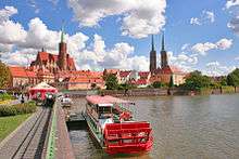
 Oder near the city of Wrocław, Poland | |
 Polen = Poland, Deutschland = Germany, and Tschechien = Czech Republic | |
| Native name | Odra Wódra |
| Location | |
| Countries | |
| Physical characteristics | |
| Source | |
| ⁃ location | Fidlův kopec, Oderské vrchy, Nízký Jeseník, Olomouc District, Olomouc Region, Moravia, Czech Republic |
| ⁃ coordinates | 49°36′47″N 017°31′15″E |
| ⁃ elevation | 634 m (2,080 ft) |
| Mouth | Szczecin Lagoon |
⁃ location | Baltic Sea, Poland |
⁃ coordinates | 53°40′19″N 14°31′25″E |
| Length | 840 km (520 mi) |
| Basin size | 119,074 km2 (45,975 sq mi) |
| Discharge | |
| ⁃ location | Mouth |
| ⁃ average | 567 m3/s (20,000 cu ft/s) |
Names
The Oder is known by several names in different languages, but the modern ones are very similar: English and German: Oder; Czech, Polish, and Lower Sorbian: Odra, Upper Sorbian: Wódra; Kashubian: Òdra (pronounced [ˈwɛdra]); Medieval Latin: Od(d)era; Renaissance Latin: Viadrus (invented in 1534).
Ptolemy knew the modern Oder as the Συήβος (Suebos; Latin Suevus), a name apparently derived from the Suebi, a Germanic people. While he also refers to an outlet in the area as the Οὐιαδούα Ouiadoua (or Οὐιλδούα Ouildoua; Latin Viadua or Vildua), this was apparently the modern Wieprza, as it was said to be a third of the distance between the Suebos and Vistula.[3][4] The name Suebos may be preserved in the modern name of the Świna river (German Swine), an outlet from the Szczecin Lagoon to the Baltic.
In the Old Church Slavonic language, the name of the river is Vjodr.[5]
Geography
The Oder is 840 kilometres (522 miles) long: 112 km (70 miles) in the Czech Republic, 726 km (451 miles) in Poland (including 187 km (116 miles) on the border between Germany and Poland) and is the third longest river located within Poland (after the Vistula and Warta), however, second longest river overall taking into account its total length, including parts in neighbouring countries.[2] It drains a basin of 119,074 square kilometres (45,975 sq mi), 106,043 km2 (40,943 sq mi) of which are in Poland (89%),[2] 7,246 km2 (2,798 sq mi) in the Czech Republic (6%), and 5,587 km2 (2,157 sq mi) in Germany (5%). Channels connect it to the Havel, Spree, Vistula system and Kłodnica. It flows through Silesian, Opole, Lower Silesian, Lubusz, and West Pomeranian voivodeships of Poland and the states of Brandenburg and Mecklenburg-Vorpommern in Germany.
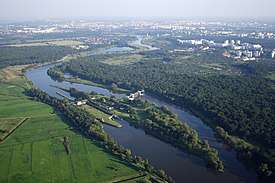
The main branch empties into the Szczecin Lagoon near Police, Poland. The Szczecin Lagoon is bordered on the north by the islands of Usedom (west) and Wolin (east). Between these two islands, there is only a narrow channel (Świna) going to the Bay of Pomerania, which forms a part of the Baltic Sea.
The largest city on the Oder is Wrocław, in Lower Silesia.
Navigation

The Oder is navigable over a large part of its total length, as far upstream as the town of Koźle, where the river connects to the Gliwice Canal. The upstream part of the river is canalized and permits larger barges (up to CEMT Class IV) to navigate between the industrial sites around the Wrocław area.
Further downstream the river is free flowing, passing the towns of Eisenhüttenstadt (where the Oder–Spree Canal connects the river to the Spree in Berlin) and Frankfurt upon Oder. Downstream of Frankfurt the river Warta forms a navigable connection with Poznań and Bydgoszcz for smaller vessels. At Hohensaaten the Oder–Havel Canal connects with the Berlin waterways again.
Near its mouth the Oder reaches the city of Szczecin, a major maritime port. The river finally reaches the Baltic Sea through the Szczecin Lagoon and the river mouth at Świnoujście.[6]
History
Under Germania Magna the river was known to the Romans as the Viadrus or Viadua in Classical Latin, as it was a branch of the Amber Road from the Baltic Sea to the Roman Empire. In Germanic languages, including English, it was and still is called the Oder, written in medieval Latin documents as Odera or Oddera. Most notably, it was mentioned in the Dagome iudex, which described territory of the Duchy of Poland under Duke Mieszko I in A.D. 990, as a part of duchy's western frontier.
Before Slavs settled along its banks, the Oder was an important trade route and towns in Germania were documented along with many tribes living between the rivers Albis (Elbe), Oder, and Vistula. Centuries later, after Germanic tribes, the Bavarian Geographer (ca. 845) specified the following West Slavic peoples: Sleenzane, Dadosesani, Opolanie, Lupiglaa, and Golensizi in Silesia and Wolinians with Pyrzycans in Western Pomerania. A document of the Bishopric of Prague (1086) mentions Zlasane, Trebovyane, Poborane, and Dedositze in Silesia.
From the 13th century on, the Oder valley was central to German Ostsiedlung, making the towns on its banks German-speaking over the following centuries.[7]
The Finow Canal, first built in 1605, connects the Oder and Havel. After completion of the more straight Oder–Havel Canal in 1914, its economic relevance decreased.
The earliest important undertaking with a view to improving the waterway was initiated by Frederick the Great, who recommended diverting the river into a new and straight channel in the swampy tract known as Oderbruch near Küstrin. The work was carried out in the years 1746–53, a large tract of marshland being brought under cultivation, a considerable detour cut off and the main stream successfully confined to a canal.
In the late 19th century, three additional alterations were made to the waterway:
- The canalization of the main stream at Breslau, and from the confluence of the Glatzer Neisse to the mouth of the Klodnitz Canal, a distance of over 50 miles (80 km). These engineering works were completed in 1896.
- During 1887–91 the Oder–Spree Canal was made to connect the two rivers.
- The deepening and regulation of the mouth and lower course of the stream.
By the Treaty of Versailles, navigation on the Oder became subject to International Commission of the Oder.[8] Following the articles 363 and 364 of the Treaty Czechoslovakia was entitled to lease in Stettin (now Szczecin) its own section in the harbour, then called Tschechoslowakische Zone im Hafen Stettin.[9] The contract of lease between Czechoslovakia and Germany, and supervised by the United Kingdom, was signed on February 16, 1929, and would end in 2028, however, after 1945 Czechoslovakia did not regain this legal position, de facto abolished in 1938–39.
At the 1943 Tehran Conference the allies decided that the new eastern border of Germany would run along the Oder.[10] However, after World War II, the German areas east of the Oder and the Lusatian Neisse were put under Polish administration by the victorious allies at the Potsdam Conference (at the insistence of the Soviets). As a result, the so-called Oder–Neisse line formed the border between the Soviet occupation zone (from 1949 East Germany) and the areas of Germany under Polish administration. The final border between Germany and Poland was to be determined at a future peace conference. A part of the German population east of these two rivers was evacuated by the Nazis during the war or fled from the approaching Red Army. After the war, the remaining 8 million Germans were forcibly expelled from these territories by the Polish and Soviet administrations.[11] East Germany confirmed the border with Poland under Soviet pressure in the Treaty of Zgorzelec in 1950. West Germany, after a period of refusal, confirmed the inviolability of the border in 1970 in the Treaty of Warsaw. In 1990 newly reunified Germany and the Republic of Poland signed a treaty recognizing the Oder–Neisse line as their border.
Cities
Main section:
- Ostrava – Bohumín – Racibórz – Kędzierzyn-Koźle – Krapkowice – Opole – Brzeg – Oława – Jelcz-Laskowice – Wrocław – Brzeg Dolny – Ścinawa – Szlichtyngowa – Głogów – Bytom Odrzański – Nowa Sól – Zielona Góra – Krosno Odrzańskie – Eisenhüttenstadt – Frankfurt (Oder) – Słubice – Kostrzyn – Cedynia – Schwedt – Vierraden – Gartz – Gryfino – Szczecin – Police
Dziwna branch (between Wolin Island and mainland Poland):
- Wolin – Kamień Pomorski – Dziwnów
Świna branch (between Wolin and the Usedom islands):
- Świnoujście
Szczecin Lagoon:
- Nowe Warpno – Ueckermünde
Peene branch (between Usedom Island and the German mainland):
- Usedom – Lassan – Wolgast
Eastern tributaries
- Ostravice – Olza – Ruda – Bierawka – Kłodnica – Czarnka – Mała Panew – Stobrawa – Widawa – Jezierzyca – Barycz – Krzycki Rów – Obrzyca – Jabłonna – Pliszka – Ołobok – Gryżynka – Warta with the Noteć – Myśla – Kurzyca – Stubia – Rurzyca – Tywa – Płonia – Ina – Gowienica - Śmieszka
Western tributaries
- Opava – Psina (Cyna) – Cisek – Olszówka – Stradunia – Osobłoga – Prószkowski Potok – Nysa Kłodzka – Oława – Ślęza – Bystrzyca – Średzka Woda – Cicha Woda – Kaczawa – Ślepca – Zimnica – Dębniak – Biała Woda – Czarna Struga – Śląska Ochla – Zimny Potok – Bóbr – Olcha – Racza – Lusatian Neisse – Finow – Gunica
See also
| Wikimedia Commons has media related to Oder River. |
- List of rivers of Germany
- List of rivers of Poland
- Lower Oder Valley National Park
- Oder–Neisse line
- Odra Wodzisław
- Ostrów Grabowski, a river island in Szczecin
References
- kontakt@naukowiec.org, naukowiec.org. "Największe rzeki w Polsce". Naukowiec.org. Retrieved 13 August 2018.
- Statistical Yearbook of the Republic of Poland 2017, Statistics Poland, p. 85-86
- Claudius Ptolemaios: Geographike Hyphegesis, Kap. 11: Germania Magna. (altgriech./lat./engl.)
- Ralf Loock: Mündungen der Flüsse bestimmt. In: Märkische Oderzeitung, Frankfurt 2008,3 (März); Ralf Loock: Namenskrimi um Viadrus in: Märkische Oderzeitung – Journal. Frankfurt 25./26. Nov. 2006, S. 2; siehe auch Alfred Stückelberger, Gerd Graßhoff (Hrsg.): Ptolemaios – Handbuch der Geographie. Schwabe, Basel 2006, S. 223, ISBN 3-7965-2148-7
- "Encyclopædia Britannica's 9th edition 1870–1890: Oder&". Archived from the original on 2013-05-06. Retrieved 2011-01-18.
- NoorderSoft Waterways Database Archived November 9, 2005, at the Wayback Machine
- e.g. Charles Higounet. Die deutsche Ostsiedlung im Mittelalter (in German). p. 175.
- The commission was staffed with one representative of Czechoslovakia, Denmark, France, Poland, Sweden, and the United Kingdom each and three representatives of Prussia, being the German state competent for the navigable section of the Oder, comprised within the latter's borders. Cf. Der Große Brockhaus: Handbuch des Wissens in zwanzig Bänden: 21 Bde., completely revised ed., Leipzig: F. A. Brockhaus, 151928-1935, vol 13 (1932): Dreizehnter Band Mue–Ost, article: 'Oder', pp. 600seq., here p. 601. No ISBN.
- Cf. Archiwum Państwowe w Szczecinie (State Archive of Szczecin), Rep. 126, Krajowy Urząd Skarbowy w Szczecinie
- Allen DJ (2003) The Oder-Neisse line: the United States, Poland, and Germany in the Cold War Praeger P13
- Gregor Thum (2011). Uprooted: How Breslau Became Wroclaw during the Century of Expulsions. Princeton University Press. p. 56.
External links
- multilingual information site on the Oder
- Odra electronic shipping guide
- Bibliography on Water Resources and International Law Peace Palace Library
Tributaries of the Oder / Odra | ||
|---|---|---|
| Main tributaries of the left bank |
| |
| Main tributaries of the right bank |
| |
| Distributary |
| |
| Cities | ||
Silesia topics | |||||||||||||||||||||||||||||
|---|---|---|---|---|---|---|---|---|---|---|---|---|---|---|---|---|---|---|---|---|---|---|---|---|---|---|---|---|---|
| |||||||||||||||||||||||||||||
| |||||||||||||||||||||||||||||
| |||||||||||||||||||||||||||||
| |||||||||||||||||||||||||||||
| |||||||||||||||||||||||||||||
| |||||||||||||||||||||||||||||

![]()
| Authority control |
|
|---|