Brandenburg
Brandenburg (/ˈbrændənbɜːrɡ/, also US: /ˈbrɑːndənbʊərk/,[5][6][7] German: [ˈbʁandn̩bʊʁk] (![]()
Brandenburg | |
|---|---|
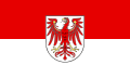 Flag  Coat of arms | |
| |
| Coordinates: 52°21′43″N 13°0′29″E | |
| Country | Germany |
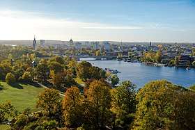
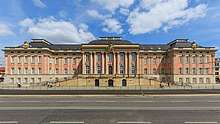
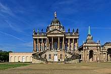
| Capital | Potsdam |
| Government | |
| • Body | Landtag of Brandenburg |
| • Minister-President | Dietmar Woidke (SPD) |
| • Governing parties | SPD / CDU / Greens |
| • Bundesrat votes | 4 (of 69) |
| Area | |
| • Total | 29,478.63 km2 (11,381.76 sq mi) |
| Population (2017-12-31)[1] | |
| • Total | 2,504,040 |
| • Density | 85/km2 (220/sq mi) |
| Time zone | UTC+1 (CET) |
| • Summer (DST) | UTC+2 (CEST) |
| ISO 3166 code | DE-BB |
| Vehicle registration | formerly: BP (1945–1947), SB (1948–1953)[2] |
| GDP (nominal) | €73 / $87 billion (2018)[3] |
| GDP per capita | €29,411 / $34,700 (2018) |
| NUTS Region | DE4 |
| HDI (2017) | 0.911[4] very high · 14th of 16 |
| Website | brandenburg.de |
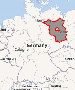
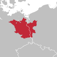
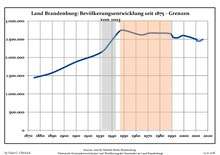
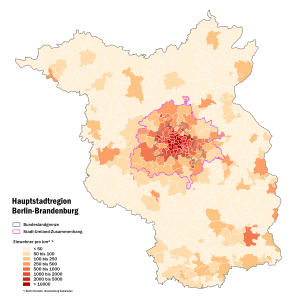
Brandenburg is located in the northeast of Germany covering an area of 29,478 square kilometres (11,382 sq mi) and has a population of 2.5 million residents, the fifth-largest German state by area and tenth-most populous. Potsdam is the state capital and largest city, while other major cities include Brandenburg an der Havel, Cottbus, and Frankfurt (Oder). Brandenburg surrounds the national capital and city-state of Berlin, which together form the Berlin/Brandenburg Metropolitan Region, the third-largest metropolitan area in Germany. Brandenburg borders the states of Mecklenburg-Vorpommern, Lower Saxony, Saxony-Anhalt, and Saxony, and the country of Poland.
Brandenburg originated in the Northern March in the 900s AD from areas conquered from the Wends, and later became the Margraviate of Brandenburg, a major principality of the Holy Roman Empire, with Albert the Bear as prince-elector. In the 15th century Brandenburg came under the rule of the House of Hohenzollern, who later also became the rulers of the Duchy of Prussia, who established Brandenburg-Prussia which eventually became the core of the later Kingdom of Prussia. Brandenburg became the Province of Brandenburg in 1815, a province within the kingdom and later within the Free State of Prussia. Brandenburg was established as a state in 1945 after World War II by the Soviet army administration in Allied-occupied Germany, and became part of the German Democratic Republic in 1947. Brandenburg was dissolved in 1952 during administrative reforms and its territory divided into the districts of Potsdam, Cottbus, Frankfurt, Neubrandenburg, and Schwerin, but was re-established in 1990 following German reunification, and became one of the Federal Republic of Germany's new states.
History
  History of Brandenburg and Prussia | ||||
| Northern March 965–983 |
Old Prussians pre-13th century | |||
| Lutician federation 983–12th century | ||||
| Margraviate of Brandenburg 1157–1618 (1806) {HRE) (Bohemia 1373–1415) |
Teutonic Order 1224–1525 (Polish fief 1466-1525) | |||
| Duchy of Prussia 1525–1618 (1701) (Polish fief 1525-1657) |
Royal (Polish) Prussia (Poland) 1454/1466–1772 | |||
| Brandenburg-Prussia 1618–1701 | ||||
| Kingdom in Prussia 1701–1772 | ||||
| Kingdom of Prussia 1772–1918 | ||||
| Free State of Prussia (Germany) 1918–1947 |
Klaipėda Region (Lithuania) 1920–1939 / 1945–present |
Recovered Territories (Poland) 1918/1945–present | ||
| Brandenburg (Germany) 1947–1952 / 1990–present |
Kaliningrad Oblast (Russia) 1945–present | |||
In late medieval and early modern times, Brandenburg was one of seven electoral states of the Holy Roman Empire, and, along with Prussia, formed the original core of the German Empire, the first unified German state. Governed by the Hohenzollern dynasty from 1415, it contained the future German capital Berlin. After 1618 the Margraviate of Brandenburg and the Duchy of Prussia were combined to form Brandenburg-Prussia, which was ruled by the same branch of the House of Hohenzollern. In 1701 the state was elevated as the Kingdom of Prussia. Franconian Nuremberg and Ansbach, Swabian Hohenzollern, the eastern European connections of Berlin, and the status of Brandenburg's ruler as prince-elector together were instrumental in the rise of that state.
Early Middle Ages
Brandenburg is situated in territory known in antiquity as Magna Germania, which reached to the Vistula river. By the 7th century, Slavic peoples are believed to have settled in the Brandenburg area. The Slavs expanded from the east, possibly driven from their homelands in present-day Ukraine and perhaps Belarus by the invasions of the Huns and Avars. They relied heavily on river transport. The two principal Slavic groups in the present-day area of Brandenburg were the Hevelli in the west and the Sprevane in the east.
Beginning in the early 10th century, Henry the Fowler and his successors conquered territory up to the Oder River. Slavic settlements such as Brenna[8] (Brandenburg an der Havel), Budusin[9] (Bautzen), and Chośebuz[10] (Cottbus) came under imperial control through the installation of margraves. Their main function was to defend and protect the eastern marches. In 948 Emperor Otto I established margraves to exert imperial control over the pagan Slavs west of the Oder River. Otto founded the Bishoprics of Brandenburg and Havelberg. The Northern March was founded as a northeastern border territory of the Holy Roman Empire. However, a great uprising of Wends drove imperial forces from the territory of present-day Brandenburg in 983. The region returned to the control of Slavic leaders.
Late Middle Ages
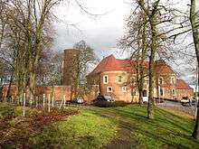
During the 12th century, the German kings and emperors re-established control over the mixed Slav-inhabited lands of present-day Brandenburg, although some Slavs like the Sorbs in Lusatia adapted to Germanization while retaining their distinctiveness. The Roman Catholic Church brought bishoprics which, with their walled towns, afforded protection from attacks for the townspeople. With the monks and bishops, the history of the town of Brandenburg an der Havel, which was the first center of the state of Brandenburg, began.
In 1134, in the wake of a German crusade against the Wends, the German magnate, Albert the Bear, was granted the Northern March by the Emperor Lothar III. He formally inherited the town of Brandenburg and the lands of the Hevelli from their last Wendish ruler, Pribislav, in 1150. After crushing a force of Sprevane who occupied the town of Brandenburg in the 1150s, Albert proclaimed himself ruler of the new Margraviate of Brandenburg. Albert, and his descendants the Ascanians, then made considerable progress in conquering, colonizing, Christianizing, and cultivating lands as far east as the Oder. Within this region, Slavic and German residents intermarried. During the 13th century, the Ascanians began acquiring territory east of the Oder, later known as the Neumark (see also Altmark).
In 1320, the Brandenburg Ascanian line came to an end, and from 1323 up until 1415 Brandenburg was under the control of the Wittelsbachs of Bavaria, followed by the Luxembourg Dynasties. Under the Luxembourgs, the Margrave of Brandenburg gained the status of a prince-elector of the Holy Roman Empire. In the period 1373–1415, Brandenburg was a part of the Bohemian Crown. In 1415, the Electorate of Brandenburg was granted by Emperor Sigismund to the House of Hohenzollern, which would rule until the end of World War I. The Hohenzollerns established their capital in Berlin, by then the economic center of Brandenburg.
16th and 17th centuries
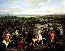
Brandenburg converted to Protestantism in 1539 in the wake of the Protestant Reformation, and generally did quite well in the 16th century, with the expansion of trade along the Elbe, Havel, and Spree Rivers. The Hohenzollerns expanded their territory by co-rulership since 1577 and acquiring the Duchy of Prussia in 1618, the Duchy of Cleves (1614) in the Rhineland, and territories in Westphalia. The result was a sprawling, disconnected country known as Brandenburg-Prussia that was in poor shape to defend itself during the Thirty Years' War.
Beginning near the end of that devastating conflict, however, Brandenburg enjoyed a string of talented rulers who expanded their territory and power in Europe. The first of these was Frederick William, the so-called "Great Elector", who worked tirelessly to rebuild and consolidate the nation. He moved the royal residence to Potsdam. At the Treaty of Westphalia, his envoy Joachim Friedrich von Blumenthal negotiated the acquisition of several important territories such as Halberstadt. Under the Treaty of Oliva Christoph Caspar von Blumenthal(son of the above) negotiated the incorporation of the Duchy of Prussia into the Hohenzollern inheritance.
Kingdom of Prussia and German Empire
When Frederick William died in 1688, he was followed by his son Frederick, third of that name in Brandenburg. As the lands that had been acquired in Prussia were outside the boundaries of the Holy Roman Empire, Frederick assumed (as Frederick I) the title of "King in Prussia" (1701). Although his self-promotion from margrave to king relied on his title to the Duchy of Prussia, Brandenburg was still the most important portion of the kingdom. However, this combined state is known as the Kingdom of Prussia.
Brandenburg remained the core of the Kingdom of Prussia, and it was the site of the kingdom's capitals, Berlin and Potsdam. When Prussia was subdivided into provinces in 1815, the territory of the Margraviate of Brandenburg became the Province of Brandenburg, again subdivided into the government regions of Frankfurt and Potsdam. In 1881, the City of Berlin was separated from the Province of Brandenburg.[11] However, industrial towns ringing Berlin lay within Brandenburg, and the growth of the region's industrial economy brought an increase in the population of the province. The Province of Brandenburg had an area of 39,039 km2 (15,073 sq mi) and a population of 2.6 million (1925). After Germany's defeat in World War II, the Neumark, the part of Brandenburg east of the Oder–Neisse line, even absent any Polish-speaking population in this area, became part of Poland. The entire population of former East Brandenburg was expelled en masse. The remainder of the province became a state in the Soviet Zone of occupation in Germany.
East Germany
After the foundation of East Germany in 1949, Brandenburg formed one of its component states. The State of Brandenburg was completely dissolved in 1952 by the Socialist government of East Germany, doing away with all component states. The East German government then divided Brandenburg among several Bezirke or districts. (See Administrative division of the German Democratic Republic). Most of Brandenburg lay within the Bezirke of Cottbus, Frankfurt, or Potsdam, but parts of the former province passed to the Schwerin, Neubrandenburg and Magdeburg districts (town Havelberg). East Germany relied heavily on lignite (the lowest grade of coal) as an energy source, and lignite strip mines marred areas of south-eastern Brandenburg. The industrial towns surrounding Berlin were important to the East German economy, while rural Brandenburg remained mainly agricultural.
Federal Republic of Germany
The present State of Brandenburg was re-established on 3 October 1990 upon German reunification.[12] The newly elected Landtag of Brandenburg first met on 26 October 1990.[13] As in other former parts of East Germany, the lack of modern infrastructure and exposure to West Germany's competitive market economy brought widespread unemployment and economic difficulty. In the recent years, however, Brandenburg's infrastructure has been modernized and unemployment has slowly declined.
In 1995, the governments of Berlin and Brandenburg proposed to merge the states in order to form a new state with the name of "Berlin-Brandenburg", though some suggested calling the proposed new state "Prussia". The merger was rejected in a plebiscite in 1996 – while West Berliners voted for a merger, East Berliners and Brandenburgers voted against it.
Geography
Brandenburg is bordered by Mecklenburg-Vorpommern in the north, Poland in the east, the Freistaat Sachsen in the south, Saxony-Anhalt in the west, and Lower Saxony in the northwest.
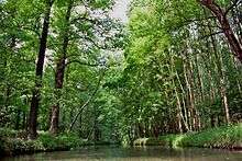
The Oder River forms a part of the eastern border, the Elbe River a portion of the western border. The main rivers in the state itself are the Spree and the Havel. In the southeast, there is a wetlands region called the Spreewald; it is the northernmost part of Lusatia, where the Sorbs, a Slavic people, still live. These areas are bilingual, i.e., German and Sorbian are both used.
Protected areas
Brandenburg is known for its well-preserved natural environment and its ambitious natural protection policies which began in the 1990s. 15 large protected areas were designated following Germany's reunification. Each of them is provided with state-financed administration and a park ranger staff, who guide visitors and work to ensure nature conservation. Most protected areas have visitor centers.
National parks
- Lower Oder Valley National Park (106 km²)
Biosphere reserves
- Spreewald Biosphere Reserve (474 km2 or 183 sq mi)
- Schorfheide-Chorin Biosphere Reserve (1,291 km2 or 498.46 sq mi)
- River Landscape Elbe-Brandenburg Biosphere Reserve (533 km2 or 206 sq mi)
Nature parks
- Barnim Nature Park (750 km2 or 290 sq mi)
- Dahme-Heideseen Nature Park (594 km2 or 229 sq mi)
- High Fläming Nature Park (827 km2 or 319 sq mi)
- Märkische Schweiz Nature Park (204 km2 or 79 sq mi)
- Niederlausitzer Heidelandschaft Nature Park (490 km2 or 189 sq mi)
- Niederlausitzer Landrücken Nature Park (580 km2 or 224 sq mi)
- Nuthe-Nieplitz Nature Park (623 km2 or 241 sq mi)
- Schlaube Valley Nature Parke (225 km2 or 87 sq mi)
- Uckermark Lakes Nature Park (895 km2 or 346 sq mi)
- Westhavelland Nature Park (1,315 km2 or 507.72 sq mi)
- Stechlin-Ruppiner Land Nature Park (1,080 km2 or 416.99 sq mi)
Cities
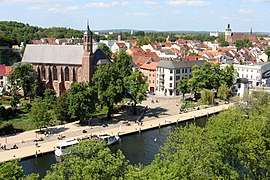 Brandenburg an der Havel
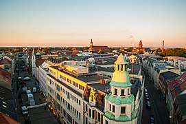 Cottbus
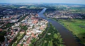 Frankfurt (Oder)
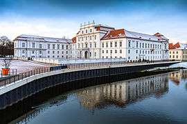 Oranienburg
Demography
| Significant foreign born populations[14] | |
| Nationality | Population (2014) |
|---|---|
| 14,802 | |
| 10,832 | |
| 7,556 | |
| 3,578 | |
| 3,344 | |
| 2,868 | |
| 2,764 | |
Religion
17.1% of the Brandenburgers are registered members of the local Evangelical Church in Germany (mostly the Evangelical Church in Berlin, Brandenburg and Silesian Upper Lusatia), while 3.1% are registered with the Roman Catholic Church (mostly the Archdiocese of Berlin, and a minority in the Diocese of Görlitz).[15] The majority (79.8%)[15] of Brandenburgers, whether of Christian or other beliefs, choose not to register with the government as members of these churches, and therefore do not pay the church tax.
Politics
Subdivisions
Brandenburg is divided into 14 rural districts (Landkreise) and four urban districts (kreisfreie Städte), shown with their population in 2011:[16]

| District | Population |
|---|---|
| 176,953 | |
| 161,556 | |
| 110,291 | |
| 155,226 | |
| 189,673 | |
| 203,508 | |
| 120,023 | |
| 182,798 | |
| 102,108 | |
| 205,678 | |
| 80,872 | |
| 124,662 | |
| 161,546 | |
| 128,174 | |
| 71,534 | |
| 102,129 | |
| 60,002 | |
| 158,902 |
Government

The most recent election took place on 14 September 2014. The coalition government formed by the Social Democrats and the Left Party led by Dietmar Woidke (SPD) was re-elected. The next ordinary state election is scheduled for 2019.
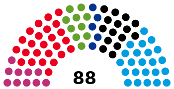 | ||||||||
| Party | Votes | % | +/- | Seats | +/- | Seats % | ||
|---|---|---|---|---|---|---|---|---|
| Social Democratic Party (SPD) | 331,238 | 26.2 | 25 | 28.4 | ||||
| Alternative for Germany (AfD) | 297,484 | 23.5 | 23 | 26.1 | ||||
| Christian Democratic Union (CDU) | 196,988 | 15.6 | 15 | 26.1 | ||||
| Alliance 90/The Greens (Grüne) | 136,364 | 10.8 | 10 | 11.4 | ||||
| The Left (Linke) | 135,558 | 10.7 | 10 | 11.4 | ||||
| Brandenburg United Civic Movements/Free Voters (BVB/FW) | 63,851 | 5.0 | 5 | 5.7 | ||||
| Free Democratic Party (FDP) | 51,660 | 4.1 | 0 | ±0 | 0 | |||
| Human Environment Animal Protection | 32,959 | 2.6 | 0 | ±0 | 0 | |||
| Pirate Party Germany (Piraten) | 8,712 | 0.7 | 0 | ±0 | 0 | |||
| Others | 10,292 | 0.8 | 0 | ±0 | 0 | |||
| Total | 1,265,106 | 100.0 | 88 | ±0 | ||||
| Voter turnout | 61.3 | |||||||
Economy
The Gross domestic product (GDP) of the state was 72.9 billion euros in 2018, accounting for 2.2% of German economic output. GDP per capita adjusted for purchasing power was 26,700 euros or 88% of the EU27 average in the same year. The GDP per employee was 91% of the EU average. The GDP per capita was the third lowest of all states in Germany.[17]
The unemployment rate stood at 5.8% in October 2018 and was higher than the German average but lower than the average of Eastern Germany.[18]
| Year[19] | 2000 | 2001 | 2002 | 2003 | 2004 | 2005 | 2006 | 2007 | 2008 | 2009 | 2010 | 2011 | 2012 | 2013 | 2014 | 2015 | 2016 | 2017 | 2018 |
|---|---|---|---|---|---|---|---|---|---|---|---|---|---|---|---|---|---|---|---|
| Unemployment rate in % | 17.0 | 17.5 | 17.5 | 18.8 | 18.7 | 18.2 | 17.0 | 14.7 | 13.0 | 12.3 | 11.1 | 10.7 | 10.2 | 9.9 | 9.4 | 8.7 | 8.0 | 7.0 | 6.3 |
Transport
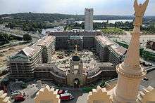
Berlin Schönefeld Airport (IATA code: SXF) is the largest airport in Brandenburg. It is the second largest international airport of the Berlin-Brandenburg metropolitan region and is located 18 km (11 mi) southeast of central Berlin in Schönefeld. The airport is a base for Condor, easyJet and Ryanair. In 2016, Schönefeld handled 11,652,922 passengers (an increase of 36.7%).
It is planned to incorporate Schönefeld's existing infrastructure and terminals into the new Berlin Brandenburg Airport (BER),[20] which is not scheduled to open before the end of 2020.[21] The new BER will have an initial capacity of 35-40 million passengers a year. Due to increasing air traffic in Berlin and Brandenburg, plans for airport expansions are in the making (as of 2017).
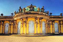
Culture
Education
In 2016, around 49,000 students were enrolled in Brandenburg universities and higher education facilities. The largest institution is the University of Potsdam, located southwest of Berlin.[22] In 2019 the state of Brandenburg adopted an Open Access strategy calling on universities to develop transformation strategies to make knowledge from Brandenburg freely accessible to all.[23]
Music
The Brandenburg concerti by Johann Sebastian Bach (original title: Six Concerts à plusieurs instruments)[24] are a collection of six instrumental works presented by Bach to Christian Ludwig, Margrave of Brandenburg-Schwedt,[25] in 1721 (though probably composed earlier). They are widely regarded as among the finest musical compositions of the Baroque era and are among the composer's best known works.
Notable people
- Theodor Fontane
- Karl Friedrich Schinkel
- Peter Joseph Lenné
See also
- Outline of Germany
- Former countries in Europe after 1815
References
- "Bevölkerung im Land Brandenburg nach amtsfreien Gemeinden, Ämtern und Gemeinden 31. Dezember 2017 (Fortgeschriebene amtliche Einwohnerzahlen auf Grundlage des Zensus 2011)". Amt für Statistik Berlin-Brandenburg (in German). 2018.
- BP = Brandenburg Province, SB = Soviet Zone, Brandenburg. With the abolition of states in East Germany in 1952 vehicle registration followed the new Bezirk subdivisions. Since 1991 distinct prefixes are specified for each district.
- "Bruttoinlandsprodukt – in jeweiligen Preisen – 1991 bis 2018". statistik-bw.de.
- "Sub-national HDI - Area Database - Global Data Lab". hdi.globaldatalab.org. Retrieved 13 September 2018.
- "Brandenburg". The American Heritage Dictionary of the English Language (5th ed.). Boston: Houghton Mifflin Harcourt. Retrieved 12 May 2019.
- "Brandenburg" (US) and "Brandenburg". Oxford Dictionaries UK Dictionary. Oxford University Press. Retrieved 12 May 2019.
- "Brandenburg". Merriam-Webster Dictionary. Retrieved 12 May 2019.
- Barford, Paul M. (2001). The Early Slavs: Culture and Society in Early Medieval Eastern Europe. Ithaca: Cornell University Press. p. 421. ISBN 0-8014-3977-9.
- Institut für Sorbische Volksforschung in Bautzen (1962). Lětopis Instituta za serbski ludospyt. Bautzen: Domowina.
- Room, Adrian (2006). Placenames of the World. Jefferson: McFarland & Company. p. 433. ISBN 0-7864-2248-3.
-

- "Ländereinführungsgesetz (1990)".
- "Archived copy". Archived from the original on 11 April 2010. Retrieved 2010-10-26.CS1 maint: archived copy as title (link)
- 31 Dec. 2014 German Statistical Office. Zensus 2014: Bevölkerung am 31. Dezember 2014
- Die kleine Brandenburg–Statistik 2011. Amt für Statistik Berlin-Brandenburg. Archived 24 August 2012 at the Wayback Machine
- "Amt für Statistik Berlin Brandenburg - Statistiken". www.statistik-berlin-brandenburg.de. Retrieved 24 April 2015.
- "Regional GDP per capita ranged from 30% to 263% of the EU average in 2018". Eurostat.
- "Arbeitslosenquote nach Bundesländern in Deutschland 2018 | Statista". Statista (in German). Retrieved 13 November 2018.
- (Destatis), © Statistisches Bundesamt (13 November 2018). "Federal Statistical Office Germany - GENESIS-Online". www-genesis.destatis.de. Retrieved 13 November 2018.
- "The future lies in Schoenefeld". Berlin-airport.de. Archived from the original on 2 May 2011.
- "The BER will remain ghost-airport until 2020", welt.de, 15. December 2017
- Brandenburg auf dem Sprung zu 2,5 Millionen-Einwohner-Marke
- Euler, Ellen (2019). "Open-Access-Strategie des Landes Brandenburg". doi:10.5281/zenodo.2581783. Cite journal requires
|journal=(help) - Johann Sebastian Bach's Werke, vol.19: Kammermusik, dritter band, Bach-Gesellschaft, Leipzig; ed. Wilhelm Rust, 1871
- MacDonogh, Giles. Frederick the Great: A Life in Deed and Letters. St. Martin's Griffin. New York. 2001. ISBN 0-312-27266-9
External links
| Wikimedia Commons has media related to Brandenburg. |
| Wikivoyage has a travel guide for Brandenburg. |
| Wikisource has the text of the 1921 Collier's Encyclopedia article Brandenburg. |
- Official website (in German)
- Brandenburg Tourist Board

| States |
|  |
|---|---|---|
| City-states | ||
| Former states |
| |
| Urban districts |
|
|---|---|
| Rural districts |
|
| Authority control |
|
|---|