Manukau City
Manukau City was a territorial authority district in Auckland, New Zealand, that was governed by the Manukau City Council. The area is sometimes referred to as "South Auckland", although this term never possessed official recognition and does not encompass areas such as East Auckland, which was within the city boundary. It was a relatively young city, both in terms of legal status and large-scale settlement – though in June 2010, it was the third largest in New Zealand, and the fastest growing.[1] In 2010, the entire Auckland Region was amalgamated under a single city authority, Auckland Council.
Manukau City | |
|---|---|
Territorial authority of New Zealand | |
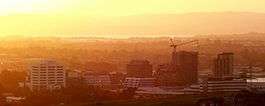 The Manukau skyline looking northwest. | |
| Nickname(s): South Auckland | |
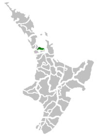 Manukau City within New Zealand | |
 Manukau City (in orange) within the Auckland metropolitan area. The darker orange indicates the urban area. | |
| Coordinates: 36°59′S 174°53′E | |
| Country | |
| Island | North Island |
| Region | Auckland |
| Wards | Botany-Clevedon, Howick, Mangere, Manurewa, Otara, Pakuranga, Papatoetoe |
| Government | |
| • Mayor | Barry Curtis (1989–2007) Len Brown (2007–2010) Phil Goff (2016–) |
| Area | |
| • Total | 683 km2 (264 sq mi) |
| Time zone | UTC+12 (NZST) |
| • Summer (DST) | UTC+13 (NZDT) |
| Area code(s) | 09 |
| Website | manukau.govt.nz |
The name Manukau, originating from the Manukau Harbour west of the city, is of Māori origin, and means "wading birds",[2] although it has been suggested that the original name of the harbour was Mānuka, meaning a marker post with which an early chief is said to have claimed the area.[3]
History
Manukau City was formed by the amalgamation of Manukau County and Manurewa Borough in 1965. The city expanded in a 1989 New Zealand-wide re-organisation of local government, absorbing Papatoetoe City and Howick Borough, but losing some land to the newly formed Papakura District. On 1 November 2010, Manukau City Council was abolished, and the governed area was amalgamated into the Manukau, Howick, Manurewa-Papakura, and Franklin wards of the new Auckland "super city".
Geography
The Manukau City area is concentrated immediately to the south of the Otahuhu isthmus, the narrowest connection between Auckland City and the Northland region and the rest of the North Island. At its narrowest, between the Otahuhu Creek arm of the Tamaki River (itself an estuarial arm of the Hauraki Gulf) in the east and the Mangere Inlet (an arm of the Manukau Harbour) to the west, the isthmus is only some 1500 metres across.
The area to the south of the isthmus contains the heart of Manukau, sprawled on either side of state highways 1 and 20, the latter of which approaches from the west after crossing Mangere Bridge. The area known as Manukau Central is located close to the junction of these two highways, some 20 kilometres southeast of the centre of Auckland city.
Considerable rural and semi-rural land to the east of Manukau Central was within the city council district. This extended towards the Hunua Ranges close to the Firth of Thames, and took in such communities as Clevedon and Maraetai.
Beyond Manukau City to the south is Papakura and the Franklin District, which are less urban, but still part of the Auckland Region, and to some extent regarded as an integral part of Auckland's urban area.
Auckland Airport is located in Mangere, in the west of Manukau, close to the waters of the Manukau Harbour. Manukau City includes the theme park Rainbow's End, and one of the oldest shopping malls in the country, now called Westfield Manukau City.
Transport
In 2009, work started on the Manukau Branch passenger railway line from the North Island Main Trunk at Puhinui.[4] The branch line opened on 15 April 2012[5] with Manukau railway station as the terminus for Eastern Line services. The Manukau Institute of Technology university campus building is built over the top of the station, which serves the Manukau city centre. On 7 April 2018, a 23-bay bus station was opened on a lot adjacent to the train station to create a transport hub serving most of the southern Auckland Region.[6]
Population
For some years before the 1989 re-organisation of local government, Manukau City had the highest population of any city or district in the country.
Like most of the rest of the region, Manukau is ethnically diverse, and is home to many peoples, especially Māori and members of Polynesian ethnicities, with a recent concentration of Asians in and near Howick. It is densely populated by New Zealand standards, despite having very few apartments.
As of the late 2000s, slightly less than 50% of the city's population identifies as European, with 17% as Māori, 27% as Pacific, and 15% as Asian, with the balance made up of other groups.[1]
Schools
Wards and populated places
Manukau City was divided into seven wards; each of them consisting of the following suburbs, towns, localities, settlements and communities:
|
Botany-Clevedon Ward
|
Howick Ward
Mangere Ward
|
Manurewa Ward
|
Otara Ward
Pakuranga Ward
Papatoetoe Ward
|
* - otherwise known as Manukau Central or Manukau CBD
Prominent people
- Len Brown, former Mayor, and former Mayor of Auckland
- Jim Anderton, former city councillor, who rose to be the country's Deputy Prime Minister
- Sir Barry Curtis, former long-serving Mayor, from 1983 to 2007
- David Lange, former Prime Minister of New Zealand and Member of Parliament for Mangere
- Award-winning rapper and former member of The Deceptikonz, Savage
Local government
The Manukau City Council was the elected local authority of the city from 1965 until November 2010 when the Auckland Council was created.
Manukau City had an elected Youth Council which primarily acted as an advisory committee and advocate for youth in the city.
Sister cities
References
- About Manukau (from the Manukau City Council website. Accessed 21 June 2008.) Archived 25 April 2008 at the Wayback Machine
- "Naming the Manukau (Manuka) Harbour". www.aucklandlibraries.govt.nz. Archived from the original on 12 July 2016. Retrieved 6 January 2016.
- Manukau – Naming the harbour (from Te Ara: The Encyclopedia of New Zealand. Accessed 22 June 2008.)
- Dearnaley, Mathew (18 September 2009). "Work starts on $90m rail link". The New Zealand Herald. Retrieved 19 October 2011.
- "New Auckland rail line opens". Radio New Zealand. 15 April 2012.
- "$49m bus station opens in Manukau". RNZ News. 7 April 2018. Retrieved 24 February 2019.
External links
| Wikivoyage has a travel guide for South Auckland. |