List of West Virginia state parks
There are 37 state parks in the U.S. state of West Virginia as of 2017.[lower-alpha 1] The West Virginia Division of Natural Resources (WVDNR) Parks and Recreation Section is the governing body for all 37 state parks and directly operates all but one of them.[lower-alpha 2] In addition to state parks, the WVDNR Parks and Recreation Section governs eight state forests.[5][6]

The first West Virginia state park, Droop Mountain Battlefield, was acquired in 1928 and dedicated in 1929; and the newest state parks, Stonewall Jackson Lake and North Bend Rail Trail, were opened in 1990 and 1991, respectively. Four parks that later joined the state park system were established prior to Droop Mountain, the earliest being the Point Pleasant Monument (now Tu-Endie-Wei) in 1901. There are seven former West Virginia state parks: one state park was transferred to the National Park Service (NPS), one to the West Virginia Division of Culture and History, one to the West Virginia Division of Highways, and one to a municipality, and three have ceased to exist entirely.
This list provides an overview of West Virginia state parks and a brief history of their development and governance since the first state park was dedicated in 1929. State parks range in size from 4 acres (2 ha) to 10,100 acres (4,087 ha). Of the 37 state parks governed by the WVDNR Parks and Recreation Section, 10 are lodge/resort state parks, 25 are cabin, camping, and day-use state parks, and 2 are rail trails.
Overview
West Virginia's state parks are governed by the West Virginia Division of Natural Resources (WVDNR) Parks and Recreation Section, which is under the jurisdiction of the West Virginia Department of Commerce.[7][8][9] The WVDNR Parks and Recreation Section manages a system of 37 state parks (including two rail trails) and eight state forests totaling around 164,000 acres (66,368 ha) of land, which consists of nearly 12,000 acres (4,856 ha) of developed lands with recreational facilities and nearly 152,000 acres (61,512 ha) of undeveloped land.[10][lower-alpha 3] In total, West Virginia has over 1.6 million acres (6,475 km2) of state and federal protected lands.[11] State parks and forests also feature more than 1,400 miles (2,253 km) of hiking trails across 45 areas.[10]
There are state parks in 30 of West Virginia's 55 counties with Pocahontas County having the most at five.[1][2] WVDNR divides the state into six regional districts to administer its state parks, forests, and wildlife management areas.[12] The largest state park by area is Watoga at 10,100 acres (4,087 ha), and Fairfax Stone and Tu-Endie-Wei are the smallest at four acres (1.6 ha).[13] Four state parks have U.S. Army Corps of Engineers (USACE) dams or reservoirs: Beech Fork, Bluestone, Stonewall Jackson Lake, and Tygart Lake.[14][15] Nine state parks feature New Deal-era buildings and structures completed between 1933 and 1942; Lost River has the most with 78.[lower-alpha 4] Cathedral is the only state park designated a National Natural Landmark,[17] and Grave Creek Mound is the only state park to have ever been designated a National Historic Landmark.[18] Stonewall Jackson Lake is the first and only West Virginia state park to be developed, constructed, financed, and operated through a public–private partnership.[4]
As of 2016, the WVDNR Parks and Recreation Section directly employed more than 400 full-time and around 1,000 seasonal and summer employees who serviced approximately 7.1 million visitors (65% state residents and 35% out-of-state).[10][19] WVDNR Parks and Recreation Section personnel maintain over 2.5 million square feet (232,258 m2) of indoor space in more than 1,500 buildings in West Virginia state parks and forests, which have an inventory of 818 lodge rooms, 369 cabins, 1,522 campsites, 144 picnic shelters, and 549 playground units.[10] The total economic impact of West Virginia state parks and forests annually is between US$160.5 million and $189.5 million and for every $1 of general tax revenue provided to state parks and forests in 2016, $13.15 on average was generated in fresh revenue for the state.[19] In 2016, visitors to state parks and forests spent $226.5 million throughout the state, of which 46% ($103.6 million) was spent by out-of-state visitors.[19] The total economic activity attributed to visitors of state parks and forests in 2016 totaled between $213.4 million and $248.7 million.[19]
Fork
Island
Creek
Creek
Logan
River
Trail
Bend
Bend
Rail
Trail
Jackson
Lake
History
West Virginia's lumber and mineral exploitation had caused tremendous damage to much of its natural environment by the early 20th century.[16] The state recognized the need to designate and protect lands worthy of conservation, and in 1925 the West Virginia Legislature established the West Virginia State Forest, Park and Conservation Commission to assess the state's opportunities and needs for forests, parks, game preserves, and recreational areas.[16][20] West Virginia's state park system began to take shape in January of that year, when the Commission purchased land in Pocahontas County for a wildlife and timber preserve that later developed into Watoga.[21]
In their report to the Legislature in 1927, the Commission recommended that scenic natural areas be acquired and administered by a State Park System under the State Game and Fish Commission and that historical monuments be administered by a State Monuments System.[20] They also identified a list of potential scenic and historic state park sites.[lower-alpha 5] One of these recommended sites became West Virginia's first state park, Droop Mountain Battlefield, also in Pocahontas County.[20] The park was acquired in 1928 and dedicated on July 4, 1929, to commemorate one of the largest battles in West Virginia during the American Civil War.[22] Four other historic locations recommended by the Commission had already been established and would later become state parks; the earliest of these was the Point Pleasant Monument (now Tu-Endie-Wei), which had been acquired by the state in 1901 and dedicated in 1909.[lower-alpha 6]
The Legislature established the West Virginia Conservation Commission Division of State Parks in 1933 to manage the state's growing park system, and to leverage the resources and expertise of the National Park Service (NPS), Civilian Conservation Corps (CCC), Works Progress Administration (WPA), and other New Deal-era programs for further park development.[27] By 1945, the Division of State Parks had expanded to 13 state parks with the addition of its first USACE reservoir park at Tygart Lake.[28] Because African Americans were denied access to West Virginia's state parks and forests, the Division of State Parks created the only state park on the basis of racial segregation, Booker T. Washington State Park, in 1949.[29] African Americans were restricted from the remainder of the state park and forest systems until the park and forest systems' integration following the Brown v. Board of Education decision by the United States Supreme Court in May 1954.[30][31][32]
By 1950, the Division of State Parks was operating 16 state parks totaling 35,973 acres (14,558 ha)[33] and by 1954, the state had expanded to 20 state parks totaling 40,355 acres (16,331 ha).[34][35] That year, the NPS noted that West Virginia had made "large percentage gains" in adding refreshments facilities to its park system, which totaled 11.[34][36] Revenue bonds allowed the park system to expand and upgrade recreational facilities and lodging throughout the 1950s,[37] and by 1960, the Division of State Parks was operating 24 state parks consisting of 40,987 acres (16,587 ha).[38] During the 1960s, the Economic Development Administration (EDA) federal loan program allowed the state to add three new parks to its system: Canaan Valley Resort, Pipestem Resort, and Twin Falls Resort.[39] Visitors to West Virginia state parks and forests totaled 4.3 million by 1968 and almost 5 million in 1971.[40][41] Following the Legislature's passing of the Economic Development Act of 1985, the West Virginia Division of Parks and Recreation was transferred from the West Virginia Conservation Commission to the West Virginia Department of Commerce, where it remains today.[8][9][42] The most recent additions to the West Virginia state park system, Stonewall Jackson Lake and North Bend Rail Trail, were added in 1990 and 1991, respectively.[4][43]
Current state parks
| Park name | Image | County and location |
Area in acres (ha)[13] |
Date of establishment |
Streams and/or lakes |
Remarks |
|---|---|---|---|---|---|---|
| Audra |  Category:Audra State Park on Wikimedia Commons | Barbour and Upshur 39°02′25″N 80°03′55″W[44] | 355 acres (144 ha) | 1950[45] | Middle Fork River[46] | Former site of the commercial logging town of Audra and of Barbour County's first 4-H camp. The park's Alum Cave is formed at the base of a sandstone formation, where it makes contact with pyritiferous shale.[45] |
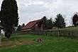
| Babcock |  Category:Babcock State Park on Wikimedia Commons | Fayette 37°59′38″N 80°58′16″W[47] | 4,127 acres (1,670 ha) | 1934[48] | Glade Creek Manns Creek[48][49] | Named for previous owner Edward V. Babcock, the park contains two architectural landmarks: its administration building, one of the major Civilian Conservation Corps (CCC) accomplishments in West Virginia, and Glade Creek Grist Mill, one of the most photographed structures in West Virginia. Completed in 1976, the mill is a working monument to the more than 500 mills formerly located in the state.[48][50][51][52] |
| Beartown |  Category:Beartown State Park on Wikimedia Commons | Greenbrier and Pocahontas 38°03′08″N 80°16′35″W[53] | 110 acres (45 ha) | 1970[54] | None[55] | Trails wind through a network of crevices between massive fragmented boulders, which are a part of the "Droop Sandstone" formation. Large elephant ear lichens (Lobaria pulmonaria) in the "Big Beartown" section of the park are more than 500 years old.[50][54] |
| Beech Fork |  Category:Beech Fork State Park on Wikimedia Commons | Cabell and Wayne 38°18′05″N 82°19′50″W[56] | 3,860 acres (1,562 ha) | 1978[57] | Beech Fork Lake[58] | Includes the 720-acre (290 ha) Beech Fork Lake, a reservoir created by a U.S. Army Corps of Engineers (USACE) dam.[57] |
| Berkeley Springs |  Category:Berkeley Springs State Park on Wikimedia Commons | Morgan 39°37′35″N 78°13′45″W[59] | 7 acres (3 ha) | 1970[60] | Warm Spring Run[61] | Listed on the National Register of Historic Places (NRHP).The park's springs, held in trust for the public since 1776, were known by European settlers as early as 1736 and were frequented by Lord Fairfax and George Washington. The temperature of the spring water remains at a constant 74.3 degrees Fahrenheit (23.5 degrees Celsius).[60][62][63][64] |
| Blackwater Falls |  Category:Blackwater Falls State Park on Wikimedia Commons | Tucker 39°06′43″N 79°29′43″W[65] | 2,358 acres (954 ha) | 1937[66] | Blackwater River North Fork Blackwater River Pendleton Lake[67] | Major attractions include 63-foot (19 m) Blackwater Falls, 8-mile (13 km) Blackwater Canyon, Elakala Falls on Shays Run, and Pendleton Falls on Pendleton Run. The park's original forests were completely lumbered by 1924, and the current secondary forests were spurred by a CCC reforestation program in the 1930s.[66][68][69] |
| Blennerhassett Island Historical |
 Category:Blennerhassett Island Historical State Park on Wikimedia Commons | Wood 39°16′16″N 81°37′34″W[70] | 511 acres (207 ha) | 1989[71] | Ohio River[72] | The park is divided between two facilities: a museum in Parkersburg and 511-acre (207 ha) Blennerhassett Island, which contains the reconstructed (1984–1991) Palladian-style Blennerhassett Mansion, originally completed in 1800. The island is accessible by paddle steamers May through October and is listed on the NRHP.[63][73][74] |
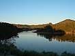
| Bluestone | 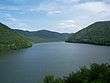 Category:Bluestone State Park on Wikimedia Commons | Summers 37°37′05″N 80°56′09″W[75] | 2,155 acres (872 ha) | 1950[76] | Bluestone River Bluestone Lake New River[77] | Named for the bluish-gray shale between sandstone deposits. Adjoins Bluestone Lake, the state's second largest body of water, which was formed as a result of Bluestone Dam, completed by the USACE in 1948.[76][78] |
| Cacapon Resort |  Category:Cacapon Resort State Park on Wikimedia Commons | Morgan 39°31′06″N 78°18′34″W[79] | 6,115 acres (2,475 ha) | 1937[80] | Cacapon Lake[81][82] | Initially constructed by the CCC beginning in 1937, with facility expansions in the 1950s and the addition of a Robert Trent Jones golf course in 1973, the park is considered a showcase of the state park system due its proximity to the Baltimore–Washington metropolitan area. The state park system’s first wobble clay shooting range was opened here in 2007.[80][83][84] |
| Camp Creek[lower-alpha 7] |  Category:Camp Creek State Park on Wikimedia Commons | Mercer 37°30′29″N 81°07′58″W[86] | 500 acres (202 ha) | 1987[87] | Camp Creek[88] | Formed from Camp Creek State Forest in 1987, when a tract of 500 acres (202 ha) was set aside to create this recreation area. It is administered with Camp Creek State Forest.[85][87] |
| Canaan Valley Resort |
 Category:Canaan Valley Resort State Park on Wikimedia Commons | Tucker 39°01′38″N 79°27′43″W[89] | 6,120 acres (2,477 ha) | 1957[90] | Blackwater River[91] | One of three state parks, along with Pipestem Resort and Twin Falls Resort, planned in the 1960s with funds from the Economic Development Administration (EDA). Contains the first ski facility in West Virginia, opened in 1971.[83][90][92] |
| Carnifex Ferry Battlefield |
 Category:Carnifex Ferry Battlefield State Park on Wikimedia Commons | Nicholas 38°12′32″N 80°56′22″W[93] | 165 acres (67 ha) | 1931[94] | Gauley River[95] | Site of 1861 American Civil War Battle of Carnifex Ferry, which secured Union control of western Virginia and eventually led to the formation of West Virginia. The park, which includes Patteson House, a restored mid-19th-century farmhouse, is listed on the NRHP.[63][94][96] |
| Cass Scenic Railroad |
 Category:Cass Scenic Railroad State Park on Wikimedia Commons | Pocahontas 38°26′55″N 79°55′38″W[97] | 940 acres (380 ha) | 1961[98] | Greenbrier River Leatherbark Run[99][100] | A former logging spur, the park's scenic railroad climbs West Virginia's second-tallest peak, Bald Knob. In addition to the railroad, the state acquired the town of Cass and restored 13 of its former company houses as rental units for park visitors, creating West Virginia's only restored company town complete with the Cass Country Store. The park is listed on the NRHP.[63][98][100][101] |
| Cathedral |  Category:Cathedral State Park on Wikimedia Commons | Preston 39°19′35″N 79°32′19″W[102] | 133 acres (54 ha) | 1942[103] | Rhine Creek[104] | Formerly known as Brookside Woods, the park is a 133-acre (54 ha) stand of uncut old-growth forest and contains the only remaining stand of virgin Eastern hemlock (Tsuga canadensis) in West Virginia. The park is entirely contained within the Brookside Historic District, which is listed on the NRHP. It was also designated a National Natural Landmark by the National Park Service.[63][105][106] |
| Cedar Creek |  Category:Cedar Creek State Park on Wikimedia Commons | Gilmer 38°52′54″N 80°51′44″W[107] | 2,588 acres (1,047 ha) | 1953[108] | Cedar Creek[109] | Contains two relocated structures of historic significance: the Log Cabin Service Station (1928), which now serves as the park office and nature center, and Pine Run School (1909), a one-room country schoolhouse with period furnishings.[108][110] |
| Chief Logan[lower-alpha 8] | 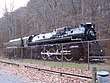 Category:Chief Logan State Park on Wikimedia Commons | Logan 37°53′57″N 82°00′46″W[112] | 3,303 acres (1,337 ha) | 1961[113] | Buffalo Creek[114] | Formerly a part of the Merrill Coal Company camp, now minus the camp's houses, mining equipment, and tipple. Performed at the park is The Aracoma Story, a historical drama about Aracoma, the daughter of Cornstalk, and the Shawnee tribespeople who lived at the present-day location.[105][113] |
| Droop Mountain Battlefield |
 Category:Droop Mountain Battlefield State Park on Wikimedia Commons | Pocahontas 38°06′43″N 80°16′17″W[115] | 287 acres (116 ha) | 1928[22][116] | None[117] | Site of the one of West Virginia's largest engagements during the American Civil War, and listed on the NRHP. Dedicated on July 4, 1929, it was the first state park established in West Virginia. In 1935, the CCC built the park's iconic wooden observation tower and a rental cabin that now serves as a museum.[63][116][118] |
| Fairfax Stone Historical Monument |
 Category:Fairfax Stone Historical Monument State Park on Wikimedia Commons | Grant, Preston, and Tucker 39°11′42″N 79°29′14″W[119] | 4 acres (2 ha) | 1957[120] | North Branch Potomac River headwaters[121][122] | The park contains the Fairfax Stone historic marker, which traditionally marked the western boundary of Lord Fairfax's Northern Neck Proprietary and is responsible for the present-day boundary between Maryland and West Virginia. The park is listed on the NRHP.[63][120][123] |
| Greenbrier River Trail |
 Category:Greenbrier River Trail on Wikimedia Commons | Greenbrier and Pocahontas 37°59′42″N 80°17′55″W[124] | 936 acres (379 ha)[123] | 1980[125] | Greenbrier River[126] | The trail is a 78-mile (126 km) section of a former Chesapeake and Ohio Railway line between North Caldwell and Cass.[13][123] |
| Hawks Nest | 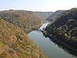 Category:Hawks Nest State Park on Wikimedia Commons | Fayette 38°07′26″N 81°07′08″W[127] | 370 acres (150 ha) | 1935[128] | Hawks Nest Lake Mill Creek New River Turkey Creek[129] | Planned by the NPS and built by the CCC, the park features an aerial tramway to a marina on the New River, and its overlook allows for panoramic views of New River Gorge. Its lodge was designed by The Architects Collaborative (TAC). A 71-acre (29 ha) historic district containing the park's CCC resources is listed on the NRHP.[63][116][130][131] |
| Holly River | 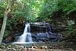 Category:Holly River State Park on Wikimedia Commons | Webster 38°39′53″N 80°20′04″W[132] | 8,294 acres (3,357 ha) | 1938[133] | Laurel Fork of Holly River[134] | The park's land was salvaged in 1937 following its purchase by the Farm Security Administration (FSA) for the purposes of reforestation and stream reclamation following extensive logging operations in the area. The park's historic district containing 93 Works Progress Administration (WPA) resources was listed on the NRHP.[63][133][135] |
| Little Beaver | 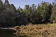 Category:Little Beaver State Park on Wikimedia Commons | Raleigh 37°44′42″N 81°05′02″W[136] | 562 acres (227 ha) | 1971[137] | Little Beaver Creek Little Beaver Lake[138] | Originally developed as a Raleigh County recreation area by the CCC in the late 1930s. Used as a county 4-H camp from 1941 to 1965. The park's lake was created in 1941 when the CCC and WPA constructed the 400-foot (122 m) Little Beaver Dam on Little Beaver Creek.[63][116][137][139] |
| Lost River |  Category:Lost River State Park on Wikimedia Commons | Hardy 38°55′22″N 78°53′22″W[140] | 3,712 acres (1,502 ha) | 1934[141] | Howards Lick Run[142] | Henry Lee III received this land in 1796 for his American Revolutionary War service. His son Charles Carter Lee founded Hardy White Sulphur Springs resort here in 1852. Later renamed Lee White Sulphur Springs, it burned down in 1910. The state acquired the land in 1934, and the NPS and CCC developed the park and its recreational facilities. The park's 142 CCC resources and its Lighthorse Harry Lee Cabin (c. 1800) are listed on the NRHP.[63][116][141][143] |
| Moncove Lake |  Category:Moncove Lake State Park on Wikimedia Commons | Monroe 37°37′19″N 80°21′04″W[144] | 896 acres (363 ha) | 1991[145] | Devil Creek Moncove Lake[146] | The park's 144-acre (58 ha) Moncove Lake was created in 1960 by the 1959 impoundment of Devil Creek. Formerly a wildlife management area, the park is located under an autumn flyway for migrating raptors, including broad-winged hawks (Buteo platypterus).[145][147][148] |
| North Bend |  Category:North Bend State Park on Wikimedia Commons | Ritchie 39°13′23″N 81°06′37″W[149] | 2,492 acres (1,009 ha) | 1951[150] | North Bend Lake North Fork Hughes River[151] | Named through a contest sponsored by the Ritchie Gazette in the 1950s, the park features the "Extra Mile Trail" for the disabled and hosts the annual International Sports Jamboree for physically or visually challenged athletes. The park's 305-acre (123 ha) North Bend Lake was created by an impoundment on the North Fork Hughes River in 2002.[150][152][153] |
| North Bend Rail Trail |
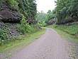 Category:North Bend Rail Trail State Park on Wikimedia Commons | Doddridge, Harrison, Ritchie, and Wood 39°17′06″N 80°58′14″W | Not applicable | 1991[43] | Goose Creek Hushers Run Little Kanawha River Middle Island Creek North Fork Hughes River Walker Creek[154] | Consists of a 72-mile (116 km) section of an abandoned spur of the CSX Transportation system between Parkersburg and Wolf Summit. Passes through 13 tunnels and over 36 bridges, and is part of the 5,500-mile (8,851 km) American Discovery Trail. The longest tunnel is the 2,207-foot (673 m) Tunnel No. 6 between West Union and Central Station.[155][156] |
| Pinnacle Rock | 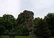 Category:Pinnacle Rock State Park on Wikimedia Commons | Mercer 37°18′43″N 81°17′32″W[157] | 374 acres (151 ha) | 1938[158][159] | Jimmy Lewis Lake[160] | Named for the 3,100-foot (945 m) tall Pinnacle Rock sandstone formation. Its rustic park facilities were built by the CCC in 1938 and the 15-acre (6 ha) Jimmy Lewis Lake was built between 1965 and 1968.[158][159][161] |
| Pipestem Resort |  Category:Pipestem Resort State Park on Wikimedia Commons | Mercer and Summers 37°32′23″N 80°59′39″W[162] | 4,050 acres (1,640 ha) | 1963[163] | Bluestone River Long Branch Creek Long Branch Lake Mountain Creek[164] | Named for the pipestem bush (Spiraea alba). Considered the "crown jewel" of the state park system upon its completion in 1971, it is one of three state parks, along with Twin Falls Resort and Canaan Valley Resort, to receive funding from the EDA. The park has a seasonal aerial tramway between the rim and floor of Bluestone Canyon, which features a vertical drop of approximately 1,200 feet (366 m).[147][163][165] |
| Prickett's Fort |  Category:Prickett's Fort State Park on Wikimedia Commons | Marion 39°31′01″N 80°05′40″W[166] | 188 acres (76 ha) | 1975[167] | Monongahela River Pricketts Creek[168][169] | Features a reconstruction of Prickett's Fort, an 18th-century fortification built to defend settlers against Native American attacks. Includes the Prickett cemetery (1772), the area's oldest burial ground. The park's Prickett's Fort and Jacob Prickett Jr. Log House are listed on the NRHP.[63][147][167][170] |
| Stonewall Jackson Lake |
 Category:Stonewall Jackson Lake State Park on Wikimedia Commons | Lewis 38°56′57″N 80°29′44″W[171] | 1,736 acres (703 ha) | 1990[4] | Stonewall Jackson Lake West Fork River[172] | Located along the 2,650-acre (1,072 ha) USACE Stonewall Jackson Lake, the park was developed, constructed, financed, and operated through a public–private partnership between McCabe-Henley LP and WVDNR.[4][173][174] |
| Tomlinson Run | 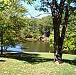 Category:Tomlinson Run State Park on Wikimedia Commons | Hancock 40°32′49″N 80°35′32″W[175] | 1,396 acres (565 ha) | 1935[176] | Tomlinson Run Tomlinson Run Lake[177] | Developed by the West Virginia Conservation Commission with support from the NPS, the park features the 30-acre (12 ha) Tomlinson Run Lake, completed by the WPA in 1942.[173][176] |
| Tu-Endie-Wei | 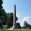 Category:Tu-Endie-Wei State Park on Wikimedia Commons | Mason 38°50′21″N 82°08′28″W[178] | 4 acres (2 ha) | 1956[23] | Kanawha River Ohio River[179][180] | Located at the confluence of the Ohio and Kanawha rivers. Site of the only major action during Lord Dunmore's War, the Battle of Point Pleasant. Acquired by the state in 1901. The granite obelisk monument commemorating the battle was dedicated in 1909, and they were added to the state park system in 1956. The park features the Mansion House Museum (c. 1796) and a monument to Cornstalk who is buried there. The park is listed on the NRHP.[23][63][173][181] |
| Twin Falls Resort |  Category:Twin Falls Resort State Park on Wikimedia Commons | Wyoming 37°38′00″N 81°26′12″W[182] | 3,776 acres (1,528 ha) | 1964[183] | Black Fork Marsh Fork[184] | Named for two waterfalls about zero point five miles (0.80 km) apart: one on the Marsh Fork and one on the Black Fork of Cabin Creek. One of three resort state parks funded by the EDA along with Canaan Valley Resort and Pipestem Resort. Contains a golf course, a reconstructed pioneer homestead serving as a living museum, and a lodge designed by TAC. Its diverse species of flora reflect an overlap of northern and southern ecosystems.[173][183][185] |
| Tygart Lake | 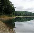 Category:Tygart Lake State Park on Wikimedia Commons | Barbour and Taylor 39°16′24″N 80°00′26″W[186] | 2,134 acres (864 ha) | 1945[187] | Tygart Lake Tygart Valley River[188] | Contains the 1,750-acre (708 ha) USACE Tygart Lake, created as a result of the Public Works Administration's Tygart Dam in 1938. The dam, designed by Charles M. Wellons and Paul Philippe Cret, is listed on the NRHP.[173][187][189][190] |
| Valley Falls | .jpg) Category:Valley Falls State Park on Wikimedia Commons | Marion and Taylor 39°23′25″N 80°05′14″W[191] | 1,145 acres (463 ha) | 1964[192] | Tygart Valley River[193] | Named for two fast-moving waterfalls of 12 feet (4 m) and 18 feet (5 m) in height on the Tygart Valley River. During the 19th century, a milling and industrial town flourished at this site.[192] |
| Watoga |  Category:Watoga State Park on Wikimedia Commons | Pocahontas 38°06′13″N 80°09′00″W[194] | 10,100 acres (4,087 ha) | 1934[195] | Greenbrier River Island Lick Run Watoga Lake[196] | Initially developed as a state forest in 1926. One of West Virginia's first CCC camps was established here in 1933. The largest of West Virginia's state parks, it contains the 11-acre (4 ha) Watoga Lake. A historic district containing the park's 103 CCC resources is listed on the NRHP.[123][195][197][198] |
| Watters Smith Memorial |
 Category:Watters Smith Memorial State Park on Wikimedia Commons | Harrison 39°10′10″N 80°24′40″W[199] | 532 acres (215 ha) | 1949[200][201] | Duck Creek[202] | Consists of the pioneer homestead of Watters Smith who moved here with his wife Elizabeth in 1796. A log cabin similar to the original was reconstructed at the park along with period farm buildings. The Smith family home (c. 1876) has also been restored as a museum. The park is listed on the NRHP.[63][200][201][203] |
Former state parks
Oak
| Park name | Image | County and location |
Area in acres (ha) |
Date of establishment |
Date of disestablishment |
Streams and/or lakes |
Remarks |
|---|---|---|---|---|---|---|---|
| Booker T. Washington | 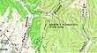 Category:Booker T. Washington State Park (West Virginia) on Wikimedia Commons | Kanawha 38°22′55″N 81°44′53″W[204] | 7.43 acres (3 ha)[205] | 1949[29] | By 1959[lower-alpha 9] | Near Finney Branch[209] | It was the only state park that allowed admission to African Americans until the park system were integrated in 1954. The park consisted of day-use picnicking facilities, but lacked a pool, hiking trails, campsites, and other amenities. Prior to the park's opening in 1949, African Americans were denied access to the state park system and were limited to the African American 4-H Camp at Camp Washington-Carver which was funded by the West Virginia State College extension service.[29][30][35][205] |
| Grandview |  Category:Grandview State Park on Wikimedia Commons | Raleigh 37°50′29″N 81°03′56″W[210] | 877 acres (355 ha)[211] | 1939[212] | 1990[211] | New River[213] | Initially constructed by the CCC, the park was named for its views of New River Gorge and the river's Horseshoe Bend. It was transferred to the NPS in 1990, and is managed as part of the New River Gorge National River. Grandview remains the home of Theatre West Virginia, which performs Hatfields and McCoys and Kermit Hunter's Honey in the Rock at Cliffside Amphitheater.[211][212][214] |
| Grave Creek Mound | 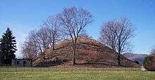 Category:Grave Creek Mound on Wikimedia Commons | Marshall 39°55′01″N 80°44′40″W[215] | 7 acres (2.83 ha)[216] | 1970[24] | 1996[217] | None[218] | The Grave Creek Mound measures 69 feet (21 m) tall and 295 feet (90 m) in diameter. Built c. 250–150 BCE, it is the largest Adena culture mound. It was purchased by the state in 1909 and maintained by the West Virginia State Penitentiary warden until 1970, when it became a state park. It was declared a National Historic Landmark in 1966. In 1996, the mound was transferred to the West Virginia Division of Culture and History, which maintains the mound and the Delf Norona Museum as the Grave Creek Mound Archaeological Complex.[24][217][219] |
| James Rumsey Monument |  Category:James Rumsey Monument on Wikimedia Commons | Jefferson 39°25′58.20″N 77°47′56.81″W[220] | 4.09 acres (1.66 ha)[25] | 1956[25] | 1978[25] | Potomac River[221] | The Rumseyan Society built the 75-foot (23 m) tall granite column as a memorial to local inventor James Rumsey in 1914 and dedicated it in 1915. The state park system operated the monument from 1956 until 1978, when operation of the monument was returned to the society and the adjoining park transferred to the Corporation of Shepherdstown. The monument provides a panoramic view of the Potomac River valley and is a contributing property to the NRHP Shepherdstown Historic District.[25][222][223] |
| Mingo Oak |  Category:Mingo Oak on Wikimedia Commons | Mingo 37°47′37″N 82°06′46″W[224] | 1.5 acres (0.61 ha)[225][226] | 1931[227] | 1938[225] | Near Trace Fork[224] | The park was leased to the state of West Virginia for the maintenance and conservation of the Mingo Oak, the oldest and largest living white oak (Quercus alba), until its felling in 1938.[225][226] |
| Mont Chateau | .jpg) Category:Mont Chateau State Park on Wikimedia Commons | Monongalia 39°39′33″N 79°50′52″W[228] | 42.16 acres (17.1 ha)[229] | 1955[229] | 1977[229] | Cheat Lake[229][230] | Located along Cheat Lake, the park and its 54-room lodge (1958) failed to develop as a tourist attraction. The lodge and 13 acres (5 ha) were leased to the West Virginia Geological and Economic Survey in 1977. The remainder of the park went to a private owner in 1985 as part of a land swap for an added tract to Holly River State Park.[229] |
| Morgan Morgan Monument | 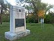 Category:Morgan Morgan Monument on Wikimedia Commons | Berkeley 39°20′07″N 78°03′11″W[231] | 1.05 acres (0.42 ha) [232][233][234] | 1956[26] | 1970[26] | Mill Creek[235] | Erected in 1924, the monument honors Morgan Morgan who is credited as the first permanent European settler in present-day West Virginia. Morgan settled in the Bunker Hill area around 1731 and is interred in a nearby cemetery. The monument and its roadside park were added to the park system in 1956 and transferred to the West Virginia Road Commission (present-day West Virginia Division of Highways) in 1970. The park is a contributing property of the NRHP Mill Creek Historic District.[26][236] |
See also
- List of West Virginia state forests
- List of West Virginia wildlife management areas
- West Virginia Division of Natural Resources
- West Virginia State Wildlife Center
Explanatory notes
- The WVDNR Parks and Recreation Section governs 37 state parks (including two rail trails), according to the West Virginia Blue Book (2016) and the West Virginia State Parks website (2017).[1][2][3]
- Stonewall Jackson Lake is operated through a public–private partnership between the WVDNR Parks and Recreation Section and McCabe-Henley LP.[4]
- The WVDNR Parks and Recreation Section refers to all its lands (state parks, rail trails, and state forests) as "state parks", and all data released by the section is inclusive of state parks, rail trails, and state forests as "state parks".[10]
- The following nine West Virginia state parks contain New Deal-era buildings and structures: Babcock (46), Cacapon Resort (50), Droop Mountain Battlefield (19), Hawks Nest (10), Holly River (26), Lost River (78), Pinnacle Rock (18), Tomlinson Run (19), and Watoga (72).[16]
- In its report to the West Virginia Legislature in 1927, the West Virginia State Forest, Park and Conservation Commission recommended the following locations for scenic state parks: Blennerhassett Island in Wood County, Coopers Rock in Monongalia and Preston counties, Cranberry Glades and its surrounding area in Pocahontas County, Hawks Nest in Fayette County, Pinnacle Rock in Mercer County, and the intersection of the Seneca and Midland trails in Greenbrier County. Seneca Rocks and Smoke Hole Caverns were also recommended; however, the Commission acknowledged that both were slated to join the new Monongahela National Forest. The Commission also recommended the following locations for historic state parks: the Battle of Philippi battlefield in Barbour County, Berkeley Springs in Morgan County, the Caddell Rifle Range near Kingwood in Preston County, Droop Mountain in Pocahontas County, Fort Ashby in Mineral County, the Grave Creek Mound in Marshall County, the James Rumsey Monument in Jefferson County, the Morgan Morgan Monument in Berkeley County, and the Point Pleasant Monument in Mason County. The Commission also deferred to the West Virginia Historical Society for further recommended historic sites for preservation as state parks.[20]
- Four parks established prior to Droop Mountain would later join the park system: the Point Pleasant Monument (now Tu-Endie-Wei) in Mason County was established in 1901 and became a state park in 1956;[23] the Grave Creek Mound in Marshall County was acquired by the state in 1909 and administered by the West Virginia State Penitentiary warden until becoming a state park in 1970;[24] the James Rumsey Monument in Jefferson County was dedicated in 1915 and made a state park in 1956;[25] and the Morgan Morgan Monument in Berkeley County was erected in 1924 and became a state park in 1956.[26]
- The WVDNR Parks and Recreation Section administers Camp Creek State Forest and Camp Creek State Park together under a single superintendent.[85]
- The WVDNR Parks and Recreation Section operates Chief Logan Lodge and Conference Center and Chief Logan State Park under separate management teams. While they are occasionally listed and counted separately in Parks and Recreation Section media, they are included together in this list as Chief Logan State Park.[111]
- Booker T. Washington State Park was not listed among a list of West Virginia state parks in the 1959 West Virginia Blue Book[206] and in the 1960 NPS tabulation of U.S. state parks.[207] The 1958 West Virginia Blue Book did not include a listing of West Virginia state parks.[208]
References
- West Virginia Legislature 2016a, pp. 75–83.
- West Virginia Legislature 2016b, pp. 1081–1088.
- "West Virginia State Parks". West Virginia State Parks website. West Virginia State Parks, West Virginia Division of Natural Resources. Archived from the original on December 3, 2017. Retrieved December 3, 2017.
- "History & Facts". Stonewall Jackson Lake State Park website. West Virginia State Parks, West Virginia Division of Natural Resources, West Virginia Department of Commerce. Archived from the original on December 1, 2017. Retrieved November 30, 2017.
- West Virginia Legislature 2016a, p. 83.
- West Virginia Legislature 2016b, pp. 1089–1090.
- "West Virginia Code". legis.state.wv.us. Archived from the original on December 4, 2017. Retrieved December 5, 2017.
- "West Virginia Code". legis.state.wv.us. Archived from the original on December 4, 2017. Retrieved December 5, 2017.
- West Virginia Legislature 2016a, p. 56.
- West Virginia Division of Natural Resources 2016, p. 42.
- West Virginia Legislature 2016b, p. 1081.
- West Virginia Division of Natural Resources 2016, p. v.
- West Virginia State Parks, West Virginia Division of Natural Resources (August 5, 2014). "West Virginia State Parks Facilities Grid" (PDF). West Virginia State Parks, West Virginia Division of Natural Resources. Archived from the original (PDF) on December 8, 2015. Retrieved August 20, 2015.
- "U.S. Army Corps of Engineers Huntington District: West Virginia Lakes and Reservoirs". U.S. Army Corps of Engineers website. U.S. Army Corps of Engineers. Archived from the original on December 2, 2017. Retrieved December 2, 2017.
- "U.S. Army Corps of Engineers Pittsburgh District: Pittsburgh District Lakes and Dams". U.S. Army Corps of Engineers website. U.S. Army Corps of Engineers. Archived from the original on December 2, 2017. Retrieved December 2, 2017.
- Sweeten, Lena L. (May 11, 2010). National Register of Historic Places Multiple Property Documentation Form: New Deal Resources in West Virginia State Parks and State Forests (PDF). United States Department of the Interior, National Park Service. p. 4 of the PDF file. Archived from the original (PDF) on December 2, 2017. Retrieved December 1, 2017.CS1 maint: ref=harv (link)
- "National Natural Landmarks by state: West Virginia". National Natural Landmarks website. National Park Service. Archived from the original on December 2, 2017. Retrieved December 1, 2017.
- "Listing of National Historic Landmarks by State: West Virginia" (PDF). National Historic Landmarks website. National Park Service. Archived from the original (PDF) on December 2, 2017. Retrieved December 2, 2017.
- West Virginia Division of Natural Resources 2016, p. 44.
- West Virginia State Park History Committee 1988, p. 8.
- Sweeten, Lena L. (May 11, 2010). National Register of Historic Places Multiple Property Documentation Form: New Deal Resources in West Virginia State Parks and State Forests (PDF). United States Department of the Interior, National Park Service. p. 5 of the PDF file. Archived from the original (PDF) on December 2, 2017. Retrieved December 1, 2017.CS1 maint: ref=harv (link)
- West Virginia State Park History Committee 1988, pp. 89–94.
- West Virginia State Park History Committee 1988, pp. 131–133.
- West Virginia State Park History Committee 1988, pp. 99–102.
- West Virginia State Park History Committee 1988, pp. 165–166.
- West Virginia State Park History Committee 1988, p. 163.
- Sweeten, Lena L. (May 11, 2010). National Register of Historic Places Multiple Property Documentation Form: New Deal Resources in West Virginia State Parks and State Forests (PDF). United States Department of the Interior, National Park Service. p. 6 of the PDF file. Archived from the original (PDF) on December 2, 2017. Retrieved December 1, 2017.CS1 maint: ref=harv (link)
- West Virginia State Park History Committee 1988, p. 6.
- O'Brien 2016, pp. 105–106.
- Johnson Publishing Company (June 10, 1954). "Negro W. Va. State Park Opened To Whites". Jet. 6 (5): 8. ISSN 0021-5996. Archived from the original on May 4, 2016. Retrieved November 30, 2017 – via Google Books.
- "Booker T. Washington Park, Opened To Whites". Delta Democrat Times. Greenville, Mississippi. May 26, 1954. p. 8. Archived from the original on December 16, 2017. Retrieved December 9, 2017 – via Newspapers.com.
- "Public-Owned Negro Park In Charleston Opened To Whites". New York Age. New York. June 12, 1954. p. 22. Archived from the original on December 16, 2017. Retrieved December 10, 2017 – via Newspapers.com.
- National Park Service Division of Recreation Planning 1950, p. 8.
- National Park Service Division of Cooperative Activities 1955, p. 7.
- National Park Service Division of Cooperative Activities 1955, p. 47.
- National Park Service Division of Cooperative Activities 1955, p. 5.
- West Virginia State Park History Committee 1988, p. 9.
- National Park Service 1960, p. 8.
- West Virginia State Park History Committee 1988, p. 10.
- "Park, Forest Visitors Rise To All-Time High". Beckley Post-Herald. Beckley, West Virginia. March 3, 1969. p. 7. Archived from the original on December 4, 2017. Retrieved December 3, 2017 – via Newspapers.com.
- "Plans Made For Tomlinson, Raccoon Park Opening". The Weirton Daily Times. Weirton, West Virginia. April 18, 1972. p. 10. Archived from the original on December 4, 2017. Retrieved December 3, 2017 – via Newspapers.com.
- West Virginia State Park History Committee 1988, p. 12.
- "North Bend Rail Trail Main Page". North Bend Rail Trail website. West Virginia State Parks, West Virginia Division of Natural Resources. Archived from the original on December 1, 2017. Retrieved November 30, 2017.
- Geographic Names Information System; United States Geological Survey. "Geographic Names Information System: Feature Detail Report for Audra State Park (Feature ID: 1535080)". Retrieved August 20, 2015.
- West Virginia State Park History Committee 1988, pp. 17–19.
- "Map of Audra State Park" (PDF). Audra State Park website. West Virginia State Parks, West Virginia Division of Natural Resources. Archived from the original (PDF) on November 30, 2017. Retrieved November 30, 2017.
- Geographic Names Information System; United States Geological Survey. "Geographic Names Information System: Feature Detail Report for Babcock State Park (Feature ID: 1535093)". Retrieved August 20, 2015.
- West Virginia State Park History Committee 1988, pp. 19–30.
- "Map of Babcock State Park" (PDF). Babcock State Park website. West Virginia State Parks, West Virginia Division of Natural Resources. Archived from the original (PDF) on November 30, 2017. Retrieved November 30, 2017.
- West Virginia Legislature 2012, p. 788.
- Chambers 2004, p. 111.
- "Babcock State Park Main Page". Babcock State Park website. West Virginia State Parks, West Virginia Division of Natural Resources. Archived from the original on December 4, 2017. Retrieved December 4, 2017.
- Geographic Names Information System; United States Geological Survey. "Geographic Names Information System: Feature Detail Report for Beartown State Park (Feature ID: 1550209)". Retrieved August 20, 2015.
- West Virginia State Park History Committee 1988, pp. 31–32.
- "Map of Beartown State Park" (PDF). Beartown State Park website. West Virginia State Parks, West Virginia Division of Natural Resources. Archived from the original (PDF) on November 30, 2017. Retrieved November 30, 2017.
- Geographic Names Information System; United States Geological Survey. "Geographic Names Information System: Feature Detail Report for Beech Fork State Park (Feature ID: 2043571)". Retrieved August 20, 2015.
- West Virginia State Park History Committee 1988, p. 33.
- "Map of Beech Fork State Park" (PDF). Beech Fork State Park website. West Virginia State Parks, West Virginia Division of Natural Resources. Archived from the original (PDF) on November 30, 2017. Retrieved November 30, 2017.
- Geographic Names Information System; United States Geological Survey. "Geographic Names Information System: Feature Detail Report for Berkeley Springs State Park (Feature ID: 1557917)". Retrieved August 20, 2015.
- West Virginia State Park History Committee 1988, pp. 34–41.
- Hancock Quadrangle, Maryland–West Virginia–Pennsylvania (PDF) (Map). 1 : 24,000. 7.5 Minute Series (Topographic). United States Geological Survey. 2016. Archived from the original (PDF) on December 1, 2017. Retrieved December 1, 2017.
- West Virginia Legislature 2012, p. 789.
- "National Register Information System". National Register of Historic Places. National Park Service. July 9, 2010. Retrieved July 25, 2015.
- Chambers 2004, pp. 519–520.
- Geographic Names Information System; United States Geological Survey. "Geographic Names Information System: Feature Detail Report for Blackwater Falls State Park (Feature ID: 1550381)". Retrieved August 20, 2015.
- West Virginia State Park History Committee 1988, pp. 42–51.
- "Map of Blackwater Falls State Park" (PDF). Blackwater Falls State Park website. West Virginia State Parks, West Virginia Division of Natural Resources. Archived from the original (PDF) on November 30, 2017. Retrieved November 30, 2017.
- Chambers 2004, pp. 493–494.
- "Breathtaking Views". Blackwater Falls State Park website. West Virginia State Parks, West Virginia Division of Natural Resources. Archived from the original on January 3, 2016. Retrieved August 20, 2015.
- Geographic Names Information System; United States Geological Survey. "Geographic Names Information System: Feature Detail Report for Blennerhassett Island Historical State Park (Feature ID: 1560348)". Retrieved August 20, 2015.
- Williams, Robert F. (February 22, 1990). "Administrative Law Judge's Recommended Decision". Public Service Commission of West Virginia: 7. Archived from the original on November 30, 2017. Retrieved November 30, 2017. Cite journal requires
|journal=(help) - "Map of Blennerhassett Island Historical State Park" (PDF). Blennerhassett Island Historical State Park website. West Virginia State Parks, West Virginia Division of Natural Resources. Archived from the original (PDF) on November 30, 2017. Retrieved November 30, 2017.
- West Virginia Legislature 2012, pp. 789–790.
- Chambers 2004, pp. 307–308.
- Geographic Names Information System; United States Geological Survey. "Geographic Names Information System: Feature Detail Report for Bluestone State Park (Feature ID: 1536147)". Retrieved August 20, 2015.
- West Virginia State Park History Committee 1988, pp. 52–54.
- "Map of Bluestone State Park" (PDF). Bluestone State Park website. West Virginia State Parks, West Virginia Division of Natural Resources. Archived from the original (PDF) on November 30, 2017. Retrieved November 30, 2017.
- Chambers 2004, p. 167.
- Geographic Names Information System; United States Geological Survey. "Geographic Names Information System: Feature Detail Report for Cacapon Resort State Park (Feature ID: 1536845)". Retrieved August 20, 2015.
- West Virginia State Park History Committee 1988, pp. 55–61.
- "Cacapon Resort State Park brochure" (PDF). Cacapon Resort State Park website. West Virginia State Parks, West Virginia Division of Natural Resources. Archived from the original (PDF) on March 4, 2016. Retrieved August 20, 2015.
- "Map of Cacapon Resort State Park" (PDF). Cacapon Resort State Park website. West Virginia State Parks, West Virginia Division of Natural Resources. Archived from the original (PDF) on November 30, 2017. Retrieved November 30, 2017.
- West Virginia Legislature 2012, p. 790.
- Chambers 2004, p. 521.
- West Virginia Legislature 2016a, p. 77.
- Geographic Names Information System; United States Geological Survey. "Geographic Names Information System: Feature Detail Report for Camp Creek State Park (Feature ID: 2043576)". Retrieved August 20, 2015.
- "Camp Creek State Park website: Welcome". Camp Creek State Park website. West Virginia State Parks, West Virginia Division of Natural Resources. Archived from the original on June 7, 2017. Retrieved August 20, 2015.
- "Map of Camp Creek State Park" (PDF). Camp Creek State Park website. West Virginia State Parks, West Virginia Division of Natural Resources. Archived from the original (PDF) on June 16, 2017. Retrieved August 20, 2015.
- Geographic Names Information System; United States Geological Survey. "Geographic Names Information System: Feature Detail Report for Canaan Valley Resort State Park (Feature ID: 1550628)". Retrieved August 20, 2015.
- West Virginia State Park History Committee 1988, pp. 62–65.
- "Map of Canaan Valley Resort State Park" (PDF). Canaan Valley Resort State Park website. West Virginia State Parks, West Virginia Division of Natural Resources. Archived from the original (PDF) on November 30, 2017. Retrieved November 30, 2017.
- Chambers 2004, p. 494.
- Geographic Names Information System; United States Geological Survey. "Geographic Names Information System: Feature Detail Report for Carnifex Ferry Battlefield State Park (Feature ID: 1537045)". Retrieved August 20, 2015.
- West Virginia State Park History Committee 1988, pp. 66–73.
- "Map of Carnifex Ferry Battlefield State Park" (PDF). Carnifex Ferry Battlefield State Park website. West Virginia State Parks, West Virginia Division of Natural Resources. Archived from the original (PDF) on November 30, 2017. Retrieved November 30, 2017.
- Chambers 2004, pp. 106–107.
- Geographic Names Information System; United States Geological Survey. "Geographic Names Information System: Feature Detail Report for Cass Scenic Railroad State Park (Feature ID: 1550645)". Retrieved August 20, 2015.
- West Virginia State Park History Committee 1988, pp. 74–81.
- "Map of Cass Scenic Railroad State Park" (PDF). Cass Scenic Railroad State Park website. West Virginia State Parks, West Virginia Division of Natural Resources. Archived from the original (PDF) on November 30, 2017. Retrieved November 30, 2017.
- Chambers 2004, pp. 472–473.
- "Cass Scenic Railroad State Park Main Page". Cass Scenic Railroad State Park website. West Virginia State Parks, West Virginia Division of Natural Resources. Archived from the original on December 4, 2017. Retrieved December 4, 2017.
- Geographic Names Information System; United States Geological Survey. "Geographic Names Information System: Feature Detail Report for Cathedral State Park (Feature ID: 1550653)". Retrieved August 20, 2015.
- West Virginia State Park History Committee 1988, pp. 82–85.
- "Map of Cathedral State Park" (PDF). Cathedral State Park website. West Virginia State Parks, West Virginia Division of Natural Resources. Archived from the original (PDF) on November 30, 2017. Retrieved November 30, 2017.
- West Virginia Legislature 2012, p. 791.
- Zimmerman, Courtney Fint (July 18, 2012). National Register of Historic Places Registration Form: Brookside Historic District (PDF). United States Department of the Interior, National Park Service. pp. 2–9 of the PDF file. Archived from the original (PDF) on November 30, 2017. Retrieved November 30, 2017.CS1 maint: ref=harv (link)
- Geographic Names Information System; United States Geological Survey. "Geographic Names Information System: Feature Detail Report for Cedar Creek State Park (Feature ID: 1537131)". Retrieved August 20, 2015.
- West Virginia State Park History Committee 1988, pp. 85–87.
- "Map of Cedar Creek State Park" (PDF). Cedar Creek State Park website. West Virginia State Parks, West Virginia Division of Natural Resources. Archived from the original (PDF) on November 30, 2017. Retrieved November 30, 2017.
- Chambers 2004, pp. 457–458.
- West Virginia Legislature 2016a, p. 78.
- Geographic Names Information System; United States Geological Survey. "Geographic Names Information System: Feature Detail Report for Chief Logan State Park (Feature ID: 1537310)". Retrieved August 20, 2015.
- West Virginia State Park History Committee 1988, pp. 87–89.
- "Map of Chief Logan State Park" (PDF). Chief Logan State Park website. West Virginia State Parks, West Virginia Division of Natural Resources. Archived from the original (PDF) on November 30, 2017. Retrieved November 30, 2017.
- Geographic Names Information System; United States Geological Survey. "Geographic Names Information System: Feature Detail Report for Droop Mountain Battlefield State Park (Feature ID: 1550954)". Retrieved August 20, 2015.
- West Virginia Legislature 2012, p. 792.
- "Map of Droop Mountain Battlefield State Park" (PDF). Droop Mountain Battlefield State Park website. West Virginia State Parks, West Virginia Division of Natural Resources. Archived from the original (PDF) on November 30, 2017. Retrieved November 30, 2017.
- Chambers 2004, pp. 470–471.
- Geographic Names Information System; United States Geological Survey. "Geographic Names Information System: Feature Detail Report for Fairfax Stone Historical Monument (Feature ID: 1697231)". Retrieved August 20, 2015.
- West Virginia State Park History Committee 1988, pp. 95–96.
- Davis Quadrangle, West Virginia–Maryland (PDF) (Map). 1 : 24,000. 7.5 Minute Series (Topographic). United States Geological Survey. 2016. Archived from the original (PDF) on November 30, 2017. Retrieved November 30, 2017.
- "Brochure for Fairfax Stone Historical Monument State Park" (PDF). West Virginia Department of Commerce website. West Virginia Department of Commerce, West Virginia Division of Natural Resources, Parks and Recreation. Archived from the original (PDF) on November 30, 2017. Retrieved November 30, 2017.
- West Virginia Legislature 2012, p. 795.
- Geographic Names Information System; United States Geological Survey. "Geographic Names Information System: Feature Detail Report for Greenbrier River Trail (Feature ID: 1551295)". Retrieved August 20, 2015.
- "Try the variety of West Virginia". Bluefield Daily Telegraph. Bluefield, West Virginia. June 10, 1986. p. 34. Retrieved November 30, 2017 – via NewspaperArchive.com.
- "Map of the Greenbrier River Trail" (PDF). Greenbrier River Trail website. West Virginia State Parks, West Virginia Division of Natural Resources. Archived from the original (PDF) on November 30, 2017. Retrieved November 30, 2017.
- Geographic Names Information System; United States Geological Survey. "Geographic Names Information System: Feature Detail Report for Hawks Nest State Park (Feature ID: 1540077)". Retrieved August 20, 2015.
- West Virginia State Park History Committee 1988, pp. 102–108.
- "Map of Hawks Nest State Park" (PDF). Hawks Nest State Park website. West Virginia State Parks, West Virginia Division of Natural Resources. Archived from the original (PDF) on November 30, 2017. Retrieved November 30, 2017.
- Chambers 2004, pp. 120–121.
- Sweeten, Lena L. (June 14, 2010). National Register of Historic Places Registration Form: New Deal Resources in Hawk’s Nest State Park Historic District (PDF). United States Department of the Interior, National Park Service. pp. 3–6 of the PDF file. Archived from the original (PDF) on November 30, 2017. Retrieved November 30, 2017.CS1 maint: ref=harv (link)
- Geographic Names Information System; United States Geological Survey. "Geographic Names Information System: Feature Detail Report for Holly River State Park (Feature ID: 1540398)". Retrieved August 20, 2015.
- West Virginia State Park History Committee 1988, pp. 109–113.
- "Map of Holly River State Park" (PDF). Holly River State Park website. West Virginia State Parks, West Virginia Division of Natural Resources. Archived from the original (PDF) on November 30, 2017. Retrieved November 30, 2017.
- Sweeten, Lena L. (June 14, 2010). National Register of Historic Places Registration Form: New Deal Resources in Holly River State Park Historic District (PDF). United States Department of the Interior, National Park Service. pp. 3–6 of the PDF file. Archived from the original (PDF) on November 30, 2017. Retrieved November 30, 2017.CS1 maint: ref=harv (link)
- Geographic Names Information System; United States Geological Survey. "Geographic Names Information System: Feature Detail Report for Little Beaver State Park (Feature ID: 1542023)". Retrieved August 20, 2015.
- Jourdan, Katherine M.; Clark, Robell (November 5, 1997). National Register of Historic Places Registration Form: Little Beaver Dam (PDF). United States Department of the Interior, National Park Service. pp. 7–10 of the PDF file. Archived from the original (PDF) on November 30, 2017. Retrieved November 30, 2017.CS1 maint: ref=harv (link)
- "Map of Little Beaver State Park" (PDF). Little Beaver State Park website. West Virginia State Parks, West Virginia Division of Natural Resources. Archived from the original (PDF) on November 30, 2017. Retrieved November 30, 2017.
- West Virginia State Park History Committee 1988, p. 113.
- Geographic Names Information System; United States Geological Survey. "Geographic Names Information System: Feature Detail Report for Lost River State Park (Feature ID: 1551946)". Retrieved August 20, 2015.
- Sweeten, Lena L. (June 14, 2010). National Register of Historic Places Registration Form: New Deal Resources in Lost River State Park Historic District (PDF). United States Department of the Interior, National Park Service. pp. 3–6 of the PDF file. Archived from the original (PDF) on November 30, 2017. Retrieved November 30, 2017.CS1 maint: ref=harv (link)
- "Map of Lost River State Park" (PDF). Lost River State Park website. West Virginia State Parks, West Virginia Division of Natural Resources. Archived from the original (PDF) on November 30, 2017. Retrieved November 30, 2017.
- West Virginia State Park History Committee 1988, pp. 114–119.
- Geographic Names Information System; United States Geological Survey. "Geographic Names Information System: Feature Detail Report for Moncove Lake Wildlife Management Area (Feature ID: 1556682)". Retrieved August 20, 2015.
- West Virginia Legislature 2016b, p. 1085.
- "Map of Moncove Lake State Park" (PDF). Moncove Lake State Park website. West Virginia State Parks, West Virginia Division of Natural Resources. Archived from the original (PDF) on November 30, 2017. Retrieved November 30, 2017.
- West Virginia Legislature 2012, p. 793.
- "Moncove Lake In Monroe County Is Known As Fisherman's Delight". Beckley Post Herald. Beckley, West Virginia. July 30, 1969. p. 10. Archived from the original on December 3, 2017. Retrieved November 30, 2017 – via Newspapers.com.
- Geographic Names Information System; United States Geological Survey. "Geographic Names Information System: Feature Detail Report for North Bend State Park (Feature ID: 1544197)". Retrieved August 20, 2015.
- West Virginia State Park History Committee 1988, pp. 120–122.
- "Map of North Bend State Park" (PDF). West Virginia Division of Natural Resources website. West Virginia State Parks, West Virginia Division of Natural Resources. Archived from the original (PDF) on November 30, 2017. Retrieved November 30, 2017.
- "Deadline looms for Sports Jamboree". News and Sentinel. Parkersburg, West Virginia. June 6, 2017. Archived from the original on November 30, 2017. Retrieved November 30, 2017.
- "North Bend Lake". West Virginia Division of Natural Resources Fish Management website. West Virginia Division of Natural Resources. Archived from the original on November 30, 2017. Retrieved November 30, 2017.
- "Brochure and Map of the North Bend Rail Trail" (PDF). West Virginia Department of Commerce website. West Virginia State Parks, West Virginia Division of Natural Resources, West Virginia Department of Commerce. Archived from the original (PDF) on November 30, 2017. Retrieved November 30, 2017.
- West Virginia Legislature 2016b, p. 1088.
- "Get Away From It All At Historic North Bend". Akron Beacon Journal. Akron, Ohio. August 28, 2016. p. E007. Archived from the original on December 3, 2017. Retrieved November 30, 2017 – via Newspapers.com.
- Geographic Names Information System; United States Geological Survey. "Geographic Names Information System: Feature Detail Report for Pinnacle Rock State Park (Feature ID: 1544944)". Retrieved August 20, 2015.
- West Virginia State Park History Committee 1988, p. 123.
- Chambers 2004, p. 196.
- "Map of Pinnacle Rock State Park" (PDF). Pinnacle Rock State Park website. West Virginia State Parks, West Virginia Division of Natural Resources. Archived from the original (PDF) on November 30, 2017. Retrieved November 30, 2017.
- "Jimmy Lewis Lake". West Virginia Division of Natural Resources Fish Management website. West Virginia Division of Natural Resources. Archived from the original on December 1, 2017. Retrieved November 30, 2017.
- Geographic Names Information System; United States Geological Survey. "Geographic Names Information System: Feature Detail Report for Pipestem State Park (Feature ID: 1544952)". Retrieved August 20, 2015.
- West Virginia State Park History Committee 1988, pp. 124–130.
- "Map of Pipestem Resort State Park" (PDF). Pipestem Resort State Park website. West Virginia State Parks, West Virginia Division of Natural Resources. Archived from the original (PDF) on November 30, 2017. Retrieved November 30, 2017.
- Chambers 2004, p. 171.
- Geographic Names Information System; United States Geological Survey. "Geographic Names Information System: Feature Detail Report for Pricketts Fort State Park (Feature ID: 1718091)". Retrieved August 20, 2015.
- West Virginia State Park History Committee 1988, pp. 134–136.
- Rivesville Quadrangle, West Virginia (PDF) (Map). 1 : 24,000. 7.5 Minute Series (Topographic). United States Geological Survey. 2016. Archived from the original (PDF) on December 1, 2017. Retrieved December 1, 2017.
- "Brochure for Prickett's Fort State Park" (PDF). West Virginia Department of Commerce website. West Virginia State Parks, West Virginia Division of Natural Resources, West Virginia Department of Commerce. Archived from the original (PDF) on November 30, 2017. Retrieved November 30, 2017.
- Chambers 2004, pp. 420–421.
- Geographic Names Information System; United States Geological Survey. "Geographic Names Information System: Feature Detail Report for Stonewall Jackson Lake State Park (Feature ID: 2043584)". Retrieved August 20, 2015.
- "Map of Stonewall Jackson Lake State Park" (PDF). Stonewall Jackson Lake State Park website. West Virginia State Parks, West Virginia Division of Natural Resources. Archived from the original (PDF) on November 30, 2017. Retrieved November 30, 2017.
- West Virginia Legislature 2012, p. 794.
- "Stonewall Jackson Lake". West Virginia Division of Natural Resources Fish Management website. West Virginia Division of Natural Resources. Archived from the original on December 1, 2017. Retrieved November 30, 2017.
- Geographic Names Information System; United States Geological Survey. "Geographic Names Information System: Feature Detail Report for Tomlinson Run State Park (Feature ID: 1548127)". Retrieved August 20, 2015.
- West Virginia State Park History Committee 1988, pp. 137–139.
- "Map of Tomlinson Run State Park" (PDF). Tomlinson Run State Park website. West Virginia State Parks, West Virginia Division of Natural Resources. Archived from the original (PDF) on November 30, 2017. Retrieved November 30, 2017.
- Geographic Names Information System; United States Geological Survey. "Geographic Names Information System: Feature Detail Report for Tu-Endie-Wei Point Pleasant Battle Monument State Park (Feature ID: 1553276)". Retrieved August 20, 2015.
- Gallipolis Quadrangle, Ohio–West Virginia (PDF) (Map). 1 : 24,000. 7.5 Minute Series (Topographic). United States Geological Survey. 2016. Archived from the original (PDF) on December 1, 2017. Retrieved December 1, 2017.
- "Brochure for Tu-Endie-Wei State Park" (PDF). West Virginia Department of Commerce website. West Virginia State Parks, West Virginia Division of Natural Resources, West Virginia Department of Commerce. Archived from the original (PDF) on November 30, 2017. Retrieved November 30, 2017.
- Chambers 2004, pp. 274–275.
- Geographic Names Information System; United States Geological Survey. "Geographic Names Information System: Feature Detail Report for Twin Falls State Park (Feature ID: 1548401)". Retrieved August 20, 2015.
- West Virginia State Park History Committee 1988, pp. 140–143.
- "Map of Twin Falls Resort State Park" (PDF). Twin Falls Resort State Park website. West Virginia State Parks, West Virginia Division of Natural Resources. Archived from the original (PDF) on November 30, 2017. Retrieved November 30, 2017.
- Chambers 2004, p. 213.
- Geographic Names Information System; United States Geological Survey. "Geographic Names Information System: Feature Detail Report for Tygart Lake State Park (Feature ID: 1548443)". Retrieved August 20, 2015.
- West Virginia State Park History Committee 1988, pp. 143–146.
- "Map of Tygart Lake State Park" (PDF). Tygart Lake State Park website. West Virginia State Parks, West Virginia Division of Natural Resources. Archived from the original (PDF) on November 30, 2017. Retrieved November 30, 2017.
- Chambers 2004, pp. 412–413.
- Maddex, Lee R. (September 7, 1994). National Register of Historic Places Registration Form: Tygart River Reservoir Dam (PDF). United States Department of the Interior, National Park Service. pp. 6–28 of the PDF file. Archived from the original (PDF) on November 30, 2017. Retrieved November 30, 2017.CS1 maint: ref=harv (link)
- Geographic Names Information System; United States Geological Survey. "Geographic Names Information System: Feature Detail Report for Valley Falls State Park (Feature ID: 1718208)". Retrieved August 20, 2015.
- West Virginia State Park History Committee 1988, pp. 146–149.
- "Map of Valley Falls State Park" (PDF). Valley Falls State Park website. West Virginia State Parks, West Virginia Division of Natural Resources. Archived from the original (PDF) on November 30, 2017. Retrieved November 30, 2017.
- Geographic Names Information System; United States Geological Survey. "Geographic Names Information System: Feature Detail Report for Watoga State Park (Feature ID: 1553392)". Retrieved August 20, 2015.
- West Virginia State Park History Committee 1988, pp. 150–157.
- "Map of Watoga State Park" (PDF). Watoga State Park website. West Virginia State Parks, West Virginia Division of Natural Resources. Archived from the original (PDF) on November 30, 2017. Retrieved November 30, 2017.
- Chambers 2004, p. 471.
- Sweeten, Lena L. (June 14, 2010). National Register of Historic Places Registration Form: New Deal Resources in Watoga State Park Historic District (PDF). United States Department of the Interior, National Park Service. pp. 3–6 of the PDF file. Archived from the original (PDF) on November 30, 2017. Retrieved November 30, 2017.CS1 maint: ref=harv (link)
- Geographic Names Information System; United States Geological Survey. "Geographic Names Information System: Feature Detail Report for Watters Smith Memorial State Park (Feature ID: 1548838)". Retrieved August 20, 2015.
- West Virginia State Park History Committee 1988, pp. 157–162.
- Chambers 2004, pp. 436–437.
- "Map of Watters Smith Memorial State Park" (PDF). Watters Smith Memorial State Park website. West Virginia State Parks, West Virginia Division of Natural Resources. Archived from the original (PDF) on November 30, 2017. Retrieved November 30, 2017.
- Post, Ann (September 11, 1971). National Register of Historic Places Registration Form: Watters Smith Memorial State Park (PDF). United States Department of the Interior, National Park Service. pp. 2–3 of the PDF file. Archived from the original (PDF) on November 30, 2017. Retrieved November 30, 2017.CS1 maint: ref=harv (link)
- Geographic Names Information System; United States Geological Survey. "Geographic Names Information System: Feature Detail Report for Booker T Washington State Park (historical) (Feature ID: 1536226)". Retrieved August 20, 2015.
- West Virginia Legislature 1954, p. 745.
- West Virginia Legislature 1959, p. 808.
- National Park Service 1960, p. 53.
- West Virginia Legislature 1958
- Pocatalico Quadrangle, West Virginia (PDF) (Map). 1 : 24,000. 7.5 Minute Series (Topographic). United States Geological Survey. 1958. OCLC 35967285. Archived from the original (PDF) on December 1, 2017. Retrieved December 1, 2017.
- Geographic Names Information System; United States Geological Survey. "Geographic Names Information System: Feature Detail Report for Grandview State Park (historical) (Feature ID: 1539580)". Retrieved August 20, 2015.
- Chambers 2004, p. 220.
- West Virginia State Park History Committee 1988, pp. 97–99.
- Prince Quadrangle West Virginia (PDF) (Map). 1 : 24,000. 7.5 Minute Series (Topographic). United States Geological Survey. 1969. OCLC 36309421. Archived from the original (PDF) on December 1, 2017. Retrieved December 1, 2017.
- "Grandview". New River Gorge National River website. National Park Service, United States Department of the Interior. Archived from the original on November 30, 2017. Retrieved November 30, 2017.
- Geographic Names Information System; United States Geological Survey. "Geographic Names Information System: Feature Detail Report for Grave Creek Indian Mound (Feature ID: 1539643)". Retrieved August 20, 2015.
- "Grave Creek Mound State Park". Grave Creek Mound State website. West Virginia State Parks, West Virginia Division of Natural Resources. Archived from the original on December 1, 2017. Retrieved December 1, 2017.
- "Division News: Grave Creek Mound's Delf Norona Museum celebrates 30th anniversary". West Virginia Archives and History. West Virginia Division of Culture and History. Archived from the original on November 30, 2017. Retrieved November 30, 2017.
- Moundsville Quadrangle, West Virginia–Ohio (PDF) (Map). 1 : 24,000. 7.5 Minute Series (Topographic). United States Geological Survey. 2016. Archived from the original (PDF) on December 1, 2017. Retrieved December 1, 2017.
- Chambers 2004, pp. 323–324.
- Geographic Names Information System; United States Geological Survey. "Geographic Names Information System: Feature Detail Report for Rumsey Monument (Feature ID: 1546151)". Retrieved December 1, 2017.
- Shepherdstown Quadrangle, West Virginia–Maryland (PDF) (Map). 1 : 24,000. 7.5 Minute Series (Topographic). United States Geological Survey. 2016. Archived from the original (PDF) on December 1, 2017. Retrieved December 1, 2017.
- Reed, Paula Stoner (September 26, 1989). National Register of Historic Places Registration Form: Shepherdstown Historic District (PDF). United States Department of the Interior, National Park Service. pp. 2–47 of the PDF file. Archived from the original (PDF) on December 1, 2017. Retrieved December 1, 2017.CS1 maint: ref=harv (link)
- Chambers 2004, p. 554.
- Holden Quadrangle, West Virginia (PDF) (Map). 1 : 24,000. 7.5 Minute Series (Topographic). United States Geological Survey. 2016. Archived from the original (PDF) on December 1, 2017. Retrieved December 1, 2017.
- King, Henry (September 18, 1938). "Mingo County White Oak Will Be Felled Friday, Fungus Is Fatal To Forest Giant After 584 Years". Huntington Herald-Advertiser. Huntington, West Virginia. Archived from the original on November 30, 2017. Retrieved November 30, 2017 – via West Virginia Division of Culture and History.
- "Mingo White Oak Believed To Be Biggest In the World". Bluefield Daily Telegraph. Bluefield, West Virginia. August 30, 1931. p. 12. Archived from the original on October 6, 2015. Retrieved November 30, 2017 – via Newspapers.com.
- "Mingo Oak: Correspondence Between Emmett Keadle and Governor William Conley Regarding the Mingo Oak". West Virginia Archives and History. West Virginia Division of Culture and History. Archived from the original on November 30, 2017. Retrieved November 30, 2017.
- Geographic Names Information System; United States Geological Survey. "Geographic Names Information System: Feature Detail Report for Mont Chateau State Park (historical) (Feature ID: 1543503)". Retrieved December 1, 2017.
- West Virginia State Park History Committee 1988, p. 164.
- Lake Lynn Quadrangle West Virginia (PDF) (Map). 1 : 24,000. 7.5 Minute Series (Topographic). United States Geological Survey. 1960. Archived from the original (PDF) on December 1, 2017. Retrieved December 1, 2017.
- Geographic Names Information System; United States Geological Survey. "Geographic Names Information System: Feature Detail Report for Morgan Morgan Park (Feature ID: 1926789)". Retrieved December 1, 2017.
- National Park Service 1960, p. 54.
- National Park Service 1964, p. 218.
- "Berkeley County Assessor's Office Tax Maps On-Line". Berkeley County Assessor's Office website. Berkeley County Assessor's Office. Archived from the original on December 26, 2017. Retrieved December 26, 2017.
- Inwood Quadrangle West Virginia (PDF) (Map). 1 : 24,000. 7.5 Minute Series (Topographic). United States Geological Survey. 2016. Archived from the original (PDF) on December 1, 2017. Retrieved December 1, 2017.
- Wood, Don C. (1980). National Register of Historic Places Registration Form: Mill Creek Historic District (PDF). United States Department of the Interior, National Park Service. pp. 3–12 of the PDF file. Archived from the original (PDF) on December 1, 2017. Retrieved December 1, 2017.CS1 maint: ref=harv (link)
Bibliography
- Chambers, S. Allen (2004). Buildings of West Virginia. Oxford, New York City: Oxford University Press. ISBN 978-0-19-516548-7. OCLC 53315276.CS1 maint: ref=harv (link)
- National Park Service (1964). Parks for America: A Survey of Park and Related Resources in Fifty States, and a Preliminary Plan. Washington, D.C.: United States Department of the Interior National Park Service. OCLC 475840999 – via Internet Archive.CS1 maint: ref=harv (link)
- National Park Service (1960). State Parks: Areas, Acreages and Accommodations. Washington, D.C.: United States Department of the Interior National Park Service. OCLC 5217001 – via Internet Archive.CS1 maint: ref=harv (link)
- National Park Service Division of Cooperative Activities (1955). State Parks: Areas, Acreages and Accommodations. Washington, D.C.: United States Department of the Interior National Park Service Division of Cooperative Activities. OCLC 12371526 – via Internet Archive.CS1 maint: ref=harv (link)
- National Park Service Division of Recreation Planning (1950). State Parks: Areas, Acreages and Accommodations. Washington, D.C.: United States Department of the Interior National Park Service Division of Recreation Planning. OCLC 966910016 – via Internet Archive.CS1 maint: ref=harv (link)
- O'Brien, William E. (2016). Landscapes of Exclusion: State Parks and Jim Crow in the American South. Amherst, Massachusetts: University of Massachusetts Press. ISBN 978-1-61376-360-5. OCLC 973123431 – via Internet Archive.CS1 maint: ref=harv (link)
- West Virginia Division of Natural Resources (2016). West Virginia Division of Natural Resources Annual Report 2015–2016 (PDF). Charleston, West Virginia: Division of Natural Resources and the Department of Commerce Communications. Archived from the original (PDF) on December 2, 2017. Retrieved December 1, 2017.CS1 maint: ref=harv (link)
- West Virginia Legislature (1954). J. Howard Myers, Clerk of the West Virginia Senate (ed.). West Virginia Blue Book, 1954. Charleston, West Virginia: Jarrett Printing Company. ISSN 0364-7323. OCLC 1251675.CS1 maint: ref=harv (link)
- West Virginia Legislature (1958). J. Howard Myers, Clerk of the West Virginia Senate (ed.). West Virginia Blue Book, 1958. Charleston, West Virginia: Jarrett Printing Company. ISSN 0364-7323. OCLC 1251675.CS1 maint: ref=harv (link)
- West Virginia Legislature (1959). J. Howard Myers, Clerk of the West Virginia Senate (ed.). West Virginia Blue Book, 1959. Charleston, West Virginia: Jarrett Printing Company. ISSN 0364-7323. OCLC 1251675.CS1 maint: ref=harv (link)
- West Virginia Legislature (2012). Darrell E. Holmes, Clerk of the West Virginia Senate (ed.). West Virginia Blue Book, 2012 (PDF). Charleston, West Virginia: Chapman Printing. ISSN 0364-7323. OCLC 1251675. Archived from the original (PDF) on December 1, 2017. Retrieved December 1, 2017.CS1 maint: ref=harv (link)
- West Virginia Legislature (2016a). "Section One: Executive". In Clark S. Barnes, Clerk of the West Virginia Senate (ed.). West Virginia Blue Book, 2016 (PDF). Charleston, West Virginia: Chapman Printing. ISSN 0364-7323. OCLC 1251675. Archived from the original (PDF) on December 1, 2017. Retrieved December 1, 2017.CS1 maint: ref=harv (link)
- West Virginia Legislature (2016b). "Section Eleven: Departmental, Statistical & General Information". In Clark S. Barnes, Clerk of the West Virginia Senate (ed.). West Virginia Blue Book, 2016 (PDF). Charleston, West Virginia: Chapman Printing. ISSN 0364-7323. OCLC 1251675. Archived from the original (PDF) on December 1, 2017. Retrieved December 1, 2017.CS1 maint: ref=harv (link)
- West Virginia State Park History Committee (1988). Where People and Nature Meet: A History of the West Virginia State Parks. Charleston, West Virginia: Pictorial Histories Publishing Company. ISBN 978-0-933126-91-6. OCLC 22116273.CS1 maint: ref=harv (link)
External links

Charleston (capital) | ||
| Topics |
|  Seal of West Virginia |
| Society |
| |
| Insignia |
| |
| Regions |
| |
| Metro areas |
| |
| Largest cities |
| |
| Counties |
| |