Chesapeake Bay Bridge
The Chesapeake Bay Bridge (known locally as the "Bay Bridge") is a major dual-span bridge in the U.S. state of Maryland. Spanning the Chesapeake Bay, it connects the state's rural Eastern Shore region with the urban Western Shore. The original span, opened in 1952 and with a length of 4.3 miles (6.9 km), was the world's longest continuous over-water steel structure. The parallel span was added in 1973. The bridge is officially named the Gov. William Preston Lane Jr. Memorial Bridge after William Preston Lane Jr. who, as the 52nd Governor of Maryland, initiated its construction in the late 1940s finally after decades of political indecision and public controversy.
Chesapeake Bay Bridge | |
|---|---|
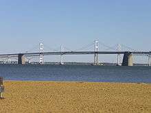
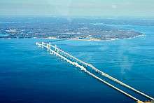
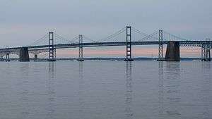 Both spans of the Chesapeake Bay Bridge (Gov. William Preston Lane Memorial Bridge) as seen from Sandy Point State Park | |
| Coordinates | 38°59′30″N 76°22′20″W |
| Carries | 5 lanes of 2 eastbound, 2 westbound, 2 reversible; either span can support 2-way traffic if the other span is completely closed)(Usually eastbound 2-way traffic is at night and westbound 2-way traffic is during the day) |
| Crosses | Chesapeake Bay |
| Locale | Anne Arundel and Queen Anne's Counties, Maryland |
| Official name | Gov. William Preston Lane Jr. Memorial Bridge |
| Other name(s) | "Bay Bridge", "Maryland Bay Bridge","America's Scariest Bridge" |
| Maintained by | Maryland Transportation Authority, State of Maryland |
| ID number | AAZ050[1][2] |
| Characteristics | |
| Design | Cantilever bridge (eastbound), Continuous truss bridge (westbound), and Suspension bridges (both spans) |
| Material | steel, concrete |
| Total length | 22,790 ft (6,946 m) or 4.316 mi (6.946 km) |
| Width | 28 ft (8.5 m) (eastbound) 38 ft (11.6 m) (westbound) |
| Longest span | 1,600 ft (488 m) |
| Clearance below | 186 ft (56.7 m) |
| History | |
| Opened | July 30, 1952 (eastbound) June 28, 1973 (westbound) |
| Statistics | |
| Daily traffic | 61,000 |
| Toll | $4.00 (2-axle, cash/non-Md E-Z Pass) $2.50 (2-axle, Maryland E-Z Pass) Applies eastbound only; no toll westbound |
| |
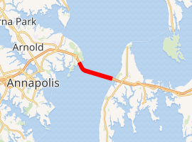
 Chesapeake Bay Bridge Location on a map of Maryland | |
The bridge is part of U.S. Route 50 (US 50) and US 301, and serves as a vital link in both routes. As part of cross-country US 50, it connects the Baltimore-Washington Metropolitan Area with Ocean City, Maryland, Rehoboth Beach, Delaware, and other coastal tourist resort destinations. As part of US 301, it serves as part of an alternative route for Interstate 95 travelers, between northern Delaware and the Washington, D.C., area. Because of this linkage, the bridge is busy and has become known as a point of traffic congestion, particularly during peak hours and summer months.
History
Proposals and ferries
Studies exploring the possibility of building a bridge across the Chesapeake Bay may have been conducted as early as the 1880s.[3]
The first known proposal came about in 1907 and called for a crossing between Baltimore and Tolchester Beach; other proposals, occurring in the years 1918, 1919, 1926, and 1935, also called for a bridge in this location.[4] In 1927, local businesspeople were authorized to finance the construction of a Baltimore to Tolchester Beach crossing. Plans for the new bridge were made, but construction was canceled following the Stock Market Crash of 1929 with the collapse of the American economy and resulting Great Depression of the 1930s.[3]
Ferries were used as the main mode of transportation across the bay from the colonial period until the completion of the 1952 bridge. The first service ran from Annapolis to Broad Creek on Kent Island, roughly where the bridge is today.[5] In 1919, the Claiborne–Annapolis Ferry Company began running ferries between Annapolis and Claiborne, a community near St. Michaels.
In July 1930, the Claiborne–Annapolis Company added a new ferry route, one running from Annapolis to Matapeake, a significantly shorter distance. The auto and passenger ferries were taken over by the State Roads Commission in 1941 (reorganized into today's State Highway Administration of the Maryland Department of Transportation in 1973). Two years later the commission moved the western terminus of the old Annapolis–Matapeake ferry to Sandy Point (later adjacent to Sandy Point State Park), shortening the cross-bay trip.
Construction of 1952 span
A 1938 proposal by the Maryland General Assembly was the first to call for a bridge at the Sandy Point–Kent Island location.[4] Although the legislation authorizing the new bridge passed, the involvement of the United States in World War II delayed the bridge's construction. In 1947, with the war over, the Assembly, under the leadership of Maryland Governor William Preston Lane Jr., (1892–1967), passed legislation directing the old State Roads Commission to begin construction.[3] Ground was broken in January 1949, and after a 3 1⁄2-year construction project, the bridge opened to traffic on July 30, 1952, as both the longest continuous over-water steel structure, and the third longest bridge in the world.[6] Before the opening, a parade of vehicles made the first official crossing, led by then current Governor Theodore Roosevelt McKeldin, (1900–1974), and other state officials in a distinctive white Cadillac convertible flying huge American and Maryland flags.[7] On November 9, 1967, the bridge was dedicated to Governor Lane, who had died earlier that year, and officially renamed the "William Preston Lane Jr. Memorial Bridge".
1973 expansion
In 1967, due to increasing traffic volumes, the Maryland General Assembly authorized three possible new crossings, all suggested during the 1964 Chesapeake Bay crossing study.[4] These included one further north near Baltimore, one in southern Maryland, and an additional span to be added to the existing bridge from Kent Island to Sandy Point; ultimately, the third option was chosen. Construction of the new parallel span began in 1969 to the north of the original bridge, and it was completed on June 28, 1973.[7]
Notable incidents
Because of its height, the narrowness of the spans (there are no hard shoulders), the low guardrails, and the frequency of high winds, it is known as one of the scariest bridges in the world,[8] especially in higher tractor-trailer trucks.[9] Several incidents have caused significant closures and traffic congestion on either side approaching the bridge.
The bridge has been closed four times due to extreme weather. The first time was September 18, 2003, during Hurricane Isabel and its high winds.[10][11] On August 27, 2011, the bridge was closed to all traffic due to the impact of Hurricane Irene. Then-Governor Martin O'Malley ordered the bridge closed when sustained winds exceeded 55 miles per hour (89 km/h). On October 29, 2012, the bridge was closed due to the effects of Hurricane Sandy.[12] On March 6, 2013, during the March 2013 nor'easter, high winds again caused the bridge to be closed.[13]
On August 10, 2008, a tractor trailer involved in a head-on collision near the west end fell from the bridge; the driver died in the crash.[14] The incident has highlighted concern that the bridge may not be structurally safe, but the Maryland Transportation Authority (MDTA) has discounted any structural or engineering problems with it.[15] Inspections of the wall in the weeks following the accident revealed that there was deterioration in the form of corrosion of the steel reinforcements inside barriers; this prompted immediate repairs to the wall.[16]
Specifications and operations
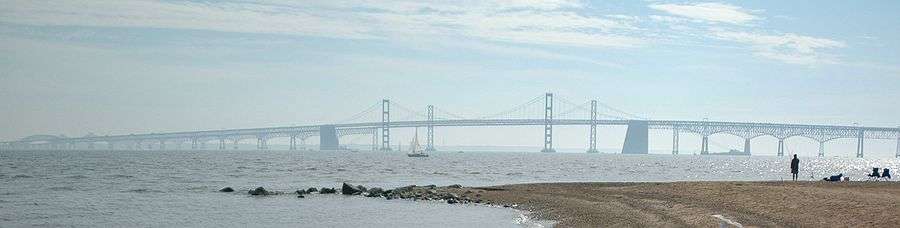
With shore-to-shore lengths of 4.33 and 4.35 miles (6.97 and 7.00 km),[3] the two spans of the bridge form the longest fixed water crossing in Maryland and ranked 102nd among the world's longest over-water structures. The bridge's western terminus is in Sandy Point State Park, located northeast of Annapolis in Anne Arundel County, and its eastern terminus is in Stevensville on Kent Island in Queen Anne's County.
Structural details
With the exception of the number of lanes on each (two on the original span and three on the newer span) and differences owing to the design standards for the periods in which they were built, the spans are structurally similar. Both were designed by J. E. Greiner Company,[17] which later became a part of AECOM through the company's acquisition of URS Corporation. Each span features:
- Two main spans over the bay's two shipping channels:
- A 3,200-foot (975 m) suspension span over the western channel with a maximum clearance of 186 feet (56.7 m)—high enough to accommodate ocean-going vessels and tall ships
- A through-truss cantilever span over the eastern channel with a maximum clearance of 58 feet (18 m)
- Deck truss and steel girder spans flanking the main spans
- Concrete beam spans on the portions closest to the shores
- A curve near the western terminus, which is required so that the main spans cross the bay's shipping channels at 90 degrees per United States Army Corps of Engineers requirements[18]
Traffic control
Traffic patterns on the bridge's five lanes can be adjusted via its lane control system, which consists of overhead lane control signals on both spans and approaches. Typically, the two lanes on the south-most span are configured for vehicles traveling east on eastbound US 50/US 301, while the three lanes on the north-most span are configured for vehicles traveling west on westbound US 50/US 301; the spans are therefore referred to as the "eastbound span" and "westbound span", respectively. However, this pattern is adjusted during incidents or peak travel times: for instance, on the outset of weekends when there is a high volume of beach-bound traffic, one lane on the westbound span is configured for eastbound traffic.
In 2006, pink markers were placed along the eastbound span to mark out the suggested following distance, similar to systems used in Minnesota and Pennsylvania. The markers are a part of the MDTA's "Pace Your Space" campaign to prevent vehicle collisions and traffic congestion due to tailgating on the bridge.[19][20]
In April 2013, changes were made to increase safety on the westbound span during two-way operations: signs, pavement markings, and rumble strips were modified, and a buffer zone between the left and center lanes was created. As a result, motorists can no longer switch between the left and center lanes, whether or not two-way operations are in effect.[21][22]
Tolls and fees
Operated by the MDTA, the bridge has a one-way toll (eastbound) of $4.00 for two-axle vehicles; vehicles with a Maryland E-ZPass pay $2.50.[23] Previously the bridge had a one-way (eastbound) toll of $6.00 for two-axle vehicles (raised from $4 on July 1, 2013); vehicles with E-ZPass that were enrolled in the Bay Bridge Commuter Plan paid $2.10 (raised from $1 on July 1, 2013).[24]
Tolls were collected in both directions until April 1989, when tolls were doubled and only collected in the Eastbound direction.[25]
The MDTA contracts with private companies to provide transportation across the bridge for nervous drivers (gephyrophobiacs) and cyclists; fees are $25 and $30 for drivers and cyclists, respectively.[26]
Bay Bridge Walk and Run
While there are no pedestrian facilities on the bridge, the Bay Bridge Walk and Governor's Bay Bridge Run used to afford an opportunity to cross the bridge on foot, usually on the first Sunday in May.[27] The events took place on the eastbound span, which was closed to vehicles while two-way traffic shared the westbound span. Participants started on the east end of the bridge (on Kent Island) and proceeded west to the finish near the toll plaza. WMATA and MTA transit buses transported participants between outlying parking areas and the start and finish points.
The run, a 10K race across the bridge, is held early in the morning before the walk. It is conducted by the Annapolis Striders, a local running organization, and controlled by the MDTA and Maryland Department of Natural Resources. Proceeds went to the Chesapeake Bay Trust in support of the bay.[28]
The walk was first held in 1975,[29] after a Boy Scout leader in Towson asked then-Governor Marvin Mandel if his troop could walk across the bridge while it was closed for maintenance.[27] The annual walk was canceled for the first time in 1980 due to poor weather conditions, and later saw frequent cancellations throughout the 2000s. During this period the walk was canceled in:
- 2002 and 2007 due to poor weather conditions.[30][31]
- 2003 and 2005 due to security concerns.[31]
- 2008, 2009, and 2010 due to construction activity in the area on the west side of the bridge where participants would otherwise be staged.[32] Fiscal concerns were also cited as a contributing factor to the 2010 cancellation.[33]
- 2011 due to fiscal concerns.[34]
- 2012 for undisclosed reasons.[35]
Following its cancellation in 2005, the MDTA considered decreasing the annual frequency of the event, citing traffic, fiscal, manpower, and security concerns. The most recent event (held in 2006) cost over $350,000, and the cost estimate for 2012 was almost $400,000. In late 2011, a non-profit group, the Greater Washington Sports Alliance (GWSA), approached the MDTA Capital Committee to propose sponsoring the event, along with a concert at Sandy Point State Park, at no cost to the MDTA. While the Capital Committee unanimously recommended that the MDTA Board approve the proposal contingent upon an agreement between the GWSA and the MDTA, the 2012 event was ultimately cancelled.[36]
After increasingly consistent cancellations of the walking event, the MDTA, along with Queen Anne's County, contracted with an outside company to have a professional 10K race across the bridge, which has been labeled the "Across the Bay 10K". The inaugural event occurred November 9, 2014.[37][38] The Race Director is Dave McGillivray,[39] who has served in that capacity for the BAA Boston Marathon since 1988. The Across the Bay 10K will have several charity beneficiaries, including bay research and restoration as well as breast cancer research and several others.[40][41]
Impact
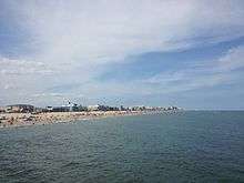
Since its construction, the bridge has made significant impacts on both sides of the bay; among them has been the growth of Eastern Shore communities. When the bridge opened in 1952, and again when the second span was added in 1973, the Eastern Shore was given easier access to Baltimore and Washington, causing areas in southern Queen Anne's County to develop as bedroom communities. This extension of the Baltimore–Washington suburbs has led Queen Anne's County to be listed as part of the Baltimore–Washington Metropolitan Area. The bridge has also given easier access to Ocean City from the Western Shore, which has caused Ocean City to grow from a small town to one that is said to become the second largest city in Maryland during the summer.[42]
In 1948, the impending completion of the bridge gave rise to an extension of US 50 to Ocean City.[43] The route was extended along the corridor of Maryland Route 404 (MD 404) and a large portion of US 213, cutting both of those routes back. During the 1950s, US 50 on the Western Shore was rerouted onto the long-proposed Annapolis–Washington Expressway (now known as the John Hanson Highway), which was built at the time in order to provide better access to the bridge.[44] As the Eastern Shore, particularly Ocean City, grew, further upgrades and realignments of US 50 took place. This work included the aforementioned 1973 completion of the second Bay Bridge span, the extension of the US 50 freeway eastward to the US 50/US 301 split in Queenstown, and the construction of a freeway bypass around the north side of Salisbury in 2002. Additionally, the road has been upgraded and realigned over the years from its original two-lane configuration to a four-lane divided highway, with the last such section being in Vienna, bypassed in 1991.[45] As of 2008, there are plans for further upgrades to US 50, including extending its freeway portion in Queen Anne's County to MD 404 outside of Wye Mills and replacing the aging Harry W. Kelly Memorial Bridge into Ocean City.[46]
The bridge is often the site of suicides by jumpers.[47][48][49][50][51]
Future expansion
In December 2004, a study concluded that traffic across the bridge was expected to increase by 40% by 2025. The following year, a task force formed by Governor Bob Ehrlich met to again explore the possibility of establishing a new Chesapeake Bay crossing.[52] The task force concluded that a bridge would be the best option for an additional crossing, and four geographic locations for such a bridge were explored: Baltimore County to Kent County, Anne Arundel County to Queen Anne's County (the existing location), Anne Arundel or Calvert County to Talbot County, and Calvert County to Dorchester County.[53] In late 2006, the task force released a report on the study but did not make a final recommendation; members of the task force requested additional time to continue the study.[54]
See also
- Kent Narrows Bridge
- List of bridges by length
- Severn River Bridge
- St. Margaret's, Maryland
- Cape St. Claire, Maryland
Notes
- Maryland State Highway Administration (2008). "Highway Location Reference: Anne Arundel County" (PDF). Retrieved February 24, 2010.
- Maryland State Highway Administration (2008). "Highway Location Reference: Queen Anne's County" (PDF). Retrieved February 24, 2010.
- "The William Preston Lane Jr. Memorial Bridge" (PDF). Maryland Transportation Authority. Retrieved October 26, 2007.
- Kozel, Scott. "Chesapeake Bay Bridge History". Roads to the Future. Retrieved October 26, 2007.
- Gayman, Jennifer. "Kent Island". Maryland Online Encyclopedia. Retrieved November 18, 2007.
- "William Preston Lane Jr. Memorial Bay Bridge: Engineering Feats". baybridge.com. Archived from the original on July 1, 2008. Retrieved February 5, 2008.
- "William Preston Lane Jr. Memorial Bay Bridge: History". baybridge.com. Archived from the original on July 1, 2008. Retrieved February 5, 2008.
- "World's Scariest Bridges". Travel and Leisure. October 2010. Retrieved September 2, 2013.
- "Don't look down! The Maryland bridge so terrifying locals pay $25 to be driven across in their own car". Daily Mail. 27 May 2013. Retrieved September 2, 2013.
- "Hurricane Isabel photo log". Indepth:Forces of Nature. CBC News. September 18, 2003. Retrieved November 16, 2007.
- Martin, Patrick (September 25, 2003). "US: Millions still without power a week after Hurricane Isabel". World Socialist Website. Retrieved November 16, 2007.
- "Chesapeake Bay Bridge Now Closed". WBOC TV. Retrieved October 29, 2012.
- "High winds force closure of Chesapeake Bay Bridge". Delaware Online. March 6, 2013. Retrieved March 19, 2013.
- St. George, Donna; Birnbaum, Michael (August 11, 2008). "Traffic Continues to Stall on Bay Bridge". The Washington Post. Retrieved August 11, 2008.
- May, Adam (August 11, 2008). "Eastbound Right Lane Reopens On Bay Bridge". WJZ. Retrieved August 12, 2008.
- Dominguez, Alex (August 27, 2008). "Bay Bridge walls had corrosion, tests show". The Free Lance-Star. Archived from the original on May 8, 2009. Retrieved August 30, 2008.
- Legler, Dixie; Highsmith, Carol (2002). Historic Bridges of Maryland. Crownsville, Md.: Maryland Historic Trust. p. 46. ISBN 1-878399-80-2. Archived from the original on 2009-05-10.
- "William Preston Lane Jr. Memorial Bridge: Fun Facts [Family Fun]". Maryland Transportation Authority. Archived from the original on September 28, 2007. Retrieved October 9, 2007.
- "SAFETY TIPS for traveling the Bay Bridge". Maryland Transportation Authority. Archived from the original on December 27, 2007. Retrieved October 9, 2007.
- Gramlich, John (July 7, 2006). "State DOTs hope drivers see dots". Stateline.Org.
- "Plans made to enhance two-way traffic operations on Chesapeake Bay Bridge". WBAL TV. Archived from the original on June 20, 2013. Retrieved June 18, 2013.
- Thomson, Candy. "Bay Bridge getting rumble strips, safety buffer zone". Baltimore Sun. Retrieved June 18, 2013.
- "Toll Rates". baybridge.maryland.gov. Maryland Transportation Authority. Retrieved June 11, 2017.
- "Toll Rates for the William Preston Lane Jr. Memorial (Bay) Bridge (US 50/301)". Maryland Transportation Authority. Retrieved July 10, 2014.
- "WESTBOUND BAY BRIDGE TOLL ENDING". Washington Post. Feb 1, 1989.
- "Safe Travel Tips". Maryland Transportation Authority. Archived from the original on October 6, 2009. Retrieved November 30, 2009.
- "Governor O'Malley Announces Plans to Host 2007 Bay Bridge Walk" (Press release). Maryland Department of Transportation. February 23, 2007. Archived from the original on November 21, 2008. Retrieved September 1, 2008.
The first Sunday in May means Bay Bridge Walk
- "The 22nd Governor's Bay Bridge Run". Annapolis Striders. Archived from the original on October 27, 2007. Retrieved November 16, 2007.
- Kozel, Scott. "Chesapeake Bay Bridge Walk". Roads to the Future. Retrieved November 16, 2007.
- Schuyler, Jim (May 6, 2007). "High Winds Cancel Bay Bridge Walk". WJZ-TV. Archived from the original on December 27, 2007. Retrieved November 16, 2007.
- Yanovits, Dave (May 7, 2007). "Race Canceled for 4th Time in Six Years". The Washington Post. Retrieved November 16, 2007.
- "Bay Bridge Walk Canceled for 2008, 2009". WTOP News. December 6, 2007. Retrieved February 6, 2008.
- Basch, Michelle. "Bay Bridge Walk cancelled for 4th year in a row". WTOP. Archived from the original on January 5, 2013. Retrieved March 14, 2010. Cite journal requires
|journal=(help) - Eric Willison (April 14, 2015). "Bay Bridge". baybridge.com. Maryland Transportation Authority. Archived from the original on March 3, 2011. Retrieved March 31, 2011.
- "No Bridge Walk Scheduled in 2012". Maryland Transportation Authority. Archived from the original on 2012-09-04.
- "Monthly Capital Meeting Minutes for October 13, 2011" (PDF). Maryland Transportation Authority.
- "Just Announced: 10K Race Across the Chesapeake Bay Bridge". Delmarva Town Crier. March 27, 2013. Retrieved July 23, 2013.
- Shatz, Jordan (April 2, 2013). "Officials say OK to bridge 10K". Retrieved July 23, 2013.
- "McGillivray to Direct 10K Across the Bay". Running USA. July 17, 2013. Archived from the original on July 27, 2014. Retrieved July 23, 2013.
- "Registration Opens for 'Across the Bay 10K' Chesapeake Bay Bridge Run Today". Wisdom Digital Media. November 9, 2013. Archived from the original on 2014-07-29. Retrieved December 5, 2013.
Runners are encouraged to fundraise for charity and last week two charities were selected to benefit from the race
- "Race Charity Partners". CBBR. Archived from the original on November 15, 2013. Retrieved December 5, 2013.
- Johnson, Darragh; Hernandez, Nelson (July 30, 2002). "Spanning Half a Century". The Washington Post. Retrieved October 9, 2007.
- "End of U.S. highway 50". August 10, 2007. Archived from the original on July 29, 2009. Retrieved November 16, 2007.
- Anderson, Steve. "John Hanson Highway". dcroads.net. Retrieved February 6, 2008.
- Dukes, Corey (August 1, 2007). "Abandoned US 50 / US 213, Vienna, MD". Delmarva Highways. Archived from the original on October 20, 2007. Retrieved October 9, 2007.
- Dukes, Corey (January 19, 2004). "Ocean Gateway – Ocean City, MD to MD 90 Interchange". Delmarva Highways. Archived from the original on September 27, 2007. Retrieved October 9, 2007.
- cahamilton@ceciwhig.com, Carl Hamilton. "Police confirm the identity of bridge jumper". Cecil Daily.
- "One man dies, another injured in jumps from Bay Bridge". Cecil Daily.
- "First responder saves man from suicide on bridge". WGBA. 12 April 2018.
- http://www.washingtontimes.com, The Washington Times. "Man jumps off Chesapeake Bay Bridge in Maryland". The Washington Times.
- "3 plunge from Bay Bridge; 2 killed". Washington Examiner. 18 April 2011.
- Berman, Dori (June 27, 2005). "Task force says second Chesapeake Bay bridge is best option". The Baltimore Daily Record. Retrieved February 5, 2008.
- "Meeting #2: Bridge, Traffic, and Highway Issues" (PDF). Maryland Transportation Authority. Archived from the original (pdf) on January 24, 2007. Retrieved February 5, 2008.
- Wyatt, Kristen (August 29, 2006). "Bay Bridge Report Released without Recommendation". WTOP news. Archived from the original on January 5, 2013. Retrieved February 5, 2008.
External links
| Wikimedia Commons has media related to Chesapeake Bay Bridge. |

- Chesapeake Bay Bridge official website
- Bay Bridge Page at MdTA website
- Roads to the Future website
- Page at dcroads.net
- Chesapeake Bay Bridge at Structurae
- Live Video Rt 50 Kent Island
- Live Video Rt 50 Sandy Point
- A 1950 comprehensive study of the economic effects of the Chesapeake Bay Bridge (pdf)
Bridges of the Chesapeake Bay | ||||
|---|---|---|---|---|
| ||||