Brackish water
Brackish water is water having more salinity than freshwater, but not as much as seawater. It may result from mixing seawater with fresh water together, as in estuaries, or it may occur in brackish fossil aquifers. The word comes from the Middle Dutch root "brak". Certain human activities can produce brackish water, in particular civil engineering projects such as dikes and the flooding of coastal marshland to produce brackish water pools for freshwater prawn farming. Brackish water is also the primary waste product of the salinity gradient power process. Because brackish water is hostile to the growth of most terrestrial plant species, without appropriate management it is damaging to the environment (see article on shrimp farms).
| Part of a series on |
| Water salinity |
|---|
 |
| Salinity levels |
|
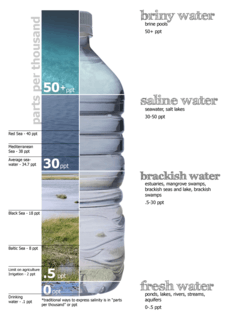
Fresh water (< 0.05%) Brackish water (0.05–3%) Saline water (3–5%) Brine (> 5% up to 26%-28% max) |
| Bodies of water |
|
Technically, brackish water contains between 0.5 and 30 grams of salt per litre—more often expressed as 0.5 to 30 parts per thousand (‰), which is a specific gravity of between 1.0004 and 1.0226. Thus, brackish covers a range of salinity regimes and is not considered a precisely defined condition. It is characteristic of many brackish surface waters that their salinity can vary considerably over space or time.
Brackish water habitats
Estuaries
Brackish water condition commonly occurs when fresh water meets seawater. In fact, the most extensive brackish water habitats worldwide are estuaries, where a river meets the sea.
The River Thames flowing through London is a classic river estuary. The town of Teddington a few miles west of London marks the boundary between the tidal and non-tidal parts of the Thames, although it is still considered a freshwater river about as far east as Battersea insofar as the average salinity is very low and the fish fauna consists predominantly of freshwater species such as roach, dace, carp, perch, and pike. The Thames Estuary becomes brackish between Battersea and Gravesend, and the diversity of freshwater fish species present is smaller, primarily roach and dace; euryhaline marine species such as flounder, European seabass, mullet, and smelt become much more common. Further east, the salinity increases and the freshwater fish species are completely replaced by euryhaline marine ones, until the river reaches Gravesend, at which point conditions become fully marine and the fish fauna resembles that of the adjacent North Sea and includes both euryhaline and stenohaline marine species. A similar pattern of replacement can be observed with the aquatic plants and invertebrates living in the river.[1][2]
This type of ecological succession from a freshwater to marine ecosystem is typical of river estuaries. River estuaries form important staging points during the migration of anadromous and catadromous fish species, such as salmon, shad and eels, giving them time to form social groups and to adjust to the changes in salinity. Salmon are anadromous, meaning they live in the sea but ascend rivers to spawn; eels are catadromous, living in rivers and streams, but returning to the sea to breed. Besides the species that migrate through estuaries, there are many other fish that use them as "nursery grounds" for spawning or as places young fish can feed and grow before moving elsewhere. Herring and plaice are two commercially important species that use the Thames Estuary for this purpose.
Estuaries are also commonly used as fishing grounds, and as places for fish farming or ranching.[3] For example, Atlantic salmon farms are often located in estuaries, although this has caused controversy, because in doing so, fish farmers expose migrating wild fish to large numbers of external parasites such as sea lice that escape from the pens the farmed fish are kept in.[4]
Mangroves
Another important brackish water habitat is the mangrove swamp or mangal. Many, though not all, mangrove swamps fringe estuaries and lagoons where the salinity changes with each tide. Among the most specialised residents of mangrove forests are mudskippers, fish that forage for food on land, and archer fish, perch-like fish that "spit" at insects and other small animals living in the trees, knocking them into the water where they can be eaten. Like estuaries, mangrove swamps are extremely important breeding grounds for many fish, with species such as snappers, halfbeaks, and tarpon spawning or maturing among them. Besides fish, numerous other animals use mangroves, including such species as the saltwater crocodile, American crocodile, proboscis monkey, diamondback terrapin, and the crab-eating frog, Fejervarya cancrivora (formerly Rana cancrivora). Mangroves represent important nesting site for numerous birds groups such as herons, storks, spoonbills, ibises, kingfishers, shorebirds and seabirds.
Although often plagued with mosquitoes and other insects that make them unpleasant for humans, mangrove swamps are very important buffer zones between land and sea, and are a natural defense against hurricane and tsunami damage in particular.[5]
The Sundarbans and Bhitarkanika Mangroves are two of the large mangrove forests in the world, both on the coast of the Bay of Bengal.
Brackish seas and lakes
Some seas and lakes are brackish. The Baltic Sea is a brackish sea adjoining the North Sea. Originally the confluence of two major river systems prior to the Pleistocene, since then it has been flooded by the North Sea but still receives so much freshwater from the adjacent lands that the water is brackish. Because the salt water coming in from the sea is denser than freshwater, the water in the Baltic is stratified, with salt water at the bottom and freshwater at the top. Limited mixing occurs because of the lack of tides and storms, with the result that the fish fauna at the surface is freshwater in composition while that lower down is more marine. Cod are an example of a species only found in deep water in the Baltic, while pike are confined to the less saline surface waters.
The Caspian Sea is the world's largest lake and contains brackish water with a salinity about one-third that of normal seawater. The Caspian is famous for its peculiar animal fauna, including one of the few non-marine seals (the Caspian seal) and the great sturgeons, a major source of caviar.
The Hudson Bay is a brackish marginal sea of the Arctic ocean, it remains brackish due its limited connections to the open ocean, very high levels freshwater surface runoff input from the large Hudson Bay drainage basin, and low rate of evaporation due to being completely covered in ice for over half the year.
In the Black Sea the surface water is brackish with an average salinity of about 17-18 parts per thousand compared to 30 to 40 for the oceans.[6] The deep, anoxic water of the Black Sea originates from warm, salty water of the Mediterranean.
Lake Texoma, a reservoir on the border between the U.S. states of Texas and Oklahoma, is a rare example of a brackish lake that is neither part of an endorheic basin nor a direct arm of the ocean, though its salinity is considerably lower than that of the other bodies of water mentioned here. The reservoir was created by the damming of the Red River of the South, which (along with several of its tributaries) receives large amounts of salt from natural seepage from buried deposits in the upstream region. The salinity is high enough that striped bass, a fish normally found only in salt water, has self-sustaining populations in the lake.[7][8]
Brackish marsh
A brackish marsh may occur where a freshwater flow enters a salt marsh.
Notable brackish bodies of water (by type, in alphabetical order)
Brackish seas
- Baltic Sea
- Black Sea (the world's largest pool of brackish water)
Brackish water lakes
- Bras d'Or Lake, Cape Breton Island, Canada
- Caspian Sea (world's largest lake)
- Lake Charles, Louisiana, United States
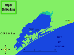
- Chilika Lake, in Odisha state, India
- Pulicat Lake, in Andhra Pradesh, India
- Issyk Kul lake, Kyrgyzstan
- Laguna de Oviedo, the Dominican Republic
- Lake Maracaibo, Venezuela
- Lake Monroe in Florida, United States.
- Lake Texoma on the border between the U.S. states of Oklahoma and Texas.
- Pangong Tso in Ladakh, part of the disputed region of Kashmir.
- Lake Van, Turkey
- Lake Mogil'noe (or Molginoye), in Kildin Island, north of Murmansk, Russia
Lochs (Scottish)
- Loch Etive (most brackish in Scotland )[9]
- Loch Long (second most brackish)[10]
- Loch of Stenness (largest Scottish brackish water lagoon)
- Loch Bee
- Loch Obisary
- Loch an Dùin
- Loch Scavaig
Coastal lagoons, marshes, and deltas
- Barnegat Bay, New Jersey, United States
- The Burgas Lakes near the Bulgarian Black Sea Coast
- The Fleet lagoon, Dorset, England
- Indian River Lagoon, Florida, United States
- Kaliveli Lake, Tamil Nadu, India
- Muthupet Lagoon, Tamil Nadu, India
- Kerala Backwaters, Kerala, India
- Lagos Lagoon in Lagos, Nigeria
- Lake Ellesmere / Te Waihora, Canterbury, New Zealand
- Lake Pontchartrain, Louisiana, United States
- Pulicat Lake, Andhra Pradesh, India
- The Rann of Kutch, on the border of India and Pakistan
- Parts of the Rhône Delta, France: An area known as the Camargue
- Widewater, a land-locked lagoon near Lancing, England
- Lagoa dos Patos, Rio Grande do Sul state, Brazil
Estuaries
- Amazon River, empties so much freshwater into the Atlantic Ocean that it reduces the salinity of the sea for hundreds of miles
- Chesapeake Bay, located in Maryland and Virginia. It is the drowned river valley of the Susquehanna River. It is the largest estuary in the United States.
- Delaware Bay, an extension of the Delaware River in New Jersey and Delaware, United States
- Great Bay, an extension of the Piscataqua River in Portsmouth, New Hampshire, United States
- Lower Hudson River, in New York and New Jersey, United States
- East River and Harlem River, New York, United States
- Lingding Yang, Guangdong, China
- Miramichi River, New Brunswick, Canada
- Mobile Bay, Alabama, United States (also the only known place in the world where jubilees regularly occur [see Mobile Bay Jubilee])
- Port Royal Sound part of Beaufort County, South Carolina, United States, The Lowcountry Estuarium – Estuary, Marsh, & Creek Life – South Carolina Coast[11]
- Río de la Plata, in Argentina and Uruguay.[12]
- Saint Lawrence and Saguenay Rivers, the part downstream from Québec and Saguenay respectively
- San Francisco Bay and San Pablo Bay, California, United States
- The Thames Estuary in South East England
- The Reversing Falls of the Saint John River, Saint John, New Brunswick, Canada.
See also
- Anchialine pool – A landlocked body of water with a subterranean connection to the ocean.
- Biosalinity
- Brackish-water aquarium
- Brine – A highly concentrated solution of a salt in water
- Desalination – Removal of salts and minerals from a substance
- Permian Sea
- Saline water
References
- The River Thames – its geology, geography and vital statistics from source to sea Archived 2010-05-16 at the Wayback Machine, The-River-Thames.co.uk
- The River Thames – its natural history Archived 2006-08-18 at the Wayback Machine The-River-Thames.co.uk
- http://www.eattilapia.com/tilapia-farming.php Archived September 29, 2010, at the Wayback Machine
- "脱毛の口コミまとめ". saveourseatrout.com. Archived from the original on 2006-07-17.
- Mangrove forests 'can reduce impact of tsunamis' Archived 2006-06-18 at the Wayback Machine, Science and Development Network, December 30, 2004
- Lüning, K., Yarish, C. & Kirkman, H. Seaweeds: their environment, biogeography, and ecophysiology. Wiley-IEEE, 1990. p. 121. ISBN 978-0-471-62434-9
- Malewitz, Jim (21 November 2013). "Communities Along Red River Seek Feds' Help." The Texas Tribune. Retrieved 25 December 2018.
- U.S. Geological Survey Fact Sheet 170-97. Retrieved 25 December 2018.
- "Archived copy" (PDF). Archived (PDF) from the original on 2015-12-08. Retrieved 2015-11-29.CS1 maint: archived copy as title (link)
- "Archived copy" (PDF). Archived from the original (PDF) on 2015-12-08. Retrieved 2015-11-29.CS1 maint: archived copy as title (link)
- "Lowcountry Estuarium — Window on the Waters". lowcountryestuarium.org. Archived from the original on 2015-07-10.
- Seeliger, Ulrich; Björn Kjerfve (2001). Coastal Marine Ecosystems of Latin America. Springer. pp. 185–204. ISBN 978-3-540-67228-9. Archived from the original on 2017-03-23.