Bosnian-Podrinje Canton Goražde
The Bosnian-Podrinje Canton Goražde (Bosnian: Bosansko-podrinjski kanton Goražde[2]) is one of ten cantons of the Federation of Bosnia and Herzegovina, an entity in Bosnia and Herzegovina.
Bosnian-Podrinje Canton Goražde
| |
|---|---|
Canton | |
 Flag  Coat of arms | |
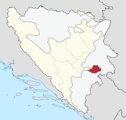 Location of the Bosnia-Podrinje Canton Goražde | |
| Coordinates: 43°40′N 18°59′E | |
| Country | Bosnia and Herzegovina |
| Entity | Federation of Bosnia and Herzegovina |
| Established | 1996 |
| Main city | Goražde |
| Municipalities | List
|
| Government | |
| • Prime Minister | Aida Obuća (SDA) |
| • President of Assembly | Edita Velić (DF) |
| Area | |
| • Total | 504.6 km2 (194.8 sq mi) |
| • Land | 504.5 km2 (194.8 sq mi) |
| • Water | 0.0179 km2 (0.0069 sq mi) |
| Population (2013 census)[1] | |
| • Total | 25,336 |
| • Density | 50.21/km2 (130.0/sq mi) |
| Area code(s) | 038 |
| ISO 3166 code | BA-05 |
| Website | http://www.bpkg.gov.ba/ |
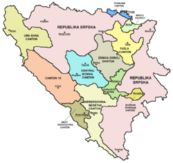
Cantons of the Federation of Bosnia and Herzegovina.
Demographics
2013 Census
| Municipality | Nationality | Total | |||||
|---|---|---|---|---|---|---|---|
Bosniaks |
% |
Croats |
% |
Serbs |
% | ||
| Goražde | 19,692 | 94.23 | 23 | 0.11 | 707 | 3.38 | 20,897 |
| Pale-Prača | 859 | 95.02 | 1 | 0.11 | 33 | 3.65 | 904 |
| Foča-Ustikolina | 1,762 | 91.15 | 0 | 0 | 145 | 7.50 | 1,933 |
| Canton | 22,313 | 94.01 | 24 | 0.10 | 885 | 3.72 | 23,734 |
Page text.[3]
Geography
It is located in the south-eastern central part of the country, in the region of Upper Drina. The cantonal seat is in Goražde.
Municipalities
The canton consists of the municipalities of Goražde, Pale-Prača, Foča-Ustikolina.
See also
- Drina Banovina
- Podrinje
- List of heads of the Bosnia-Podrinje Canton Goražde
References
- "First release" (PDF). Federal Office of Statistics, Federation of Bosnia and Herzegovina. June 30, 2011. Archived from the original (PDF) on 2013-05-11.
- "USTAV BOSANSKO-PODRINJSKOG KANTONA GORAŽDE" (PDF).
- Link text, additional text.
Cantons of the Federation of Bosnia and Herzegovina | |||||||
|---|---|---|---|---|---|---|---|
| |||||||
Political divisions of Bosnia and Herzegovina | |||||||||||||||
|---|---|---|---|---|---|---|---|---|---|---|---|---|---|---|---|
| |||||||||||||||
| |||||||||||||||
| |||||||||||||||
| |||||||||||||||
This article is issued from
Wikipedia.
The text is licensed under Creative
Commons - Attribution - Sharealike.
Additional terms may apply for the media files.