Zirl, Tyrol
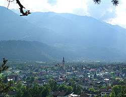
Zirl is a market town in the district of Innsbruck-Land in the Austrian state of Tyrol located 10 km west of Innsbruck at the bottom of a pass up the side of the Zirler Berg, leading to Seefeld and ultimately to Germany. The location was mentioned as "Cyreolu" and "Cyreola" in documents in 799 for the first time.[3][4] Zirl was damaged several times by floods and fires but nevertheless the population has increased in recent years. The status "Market town" was received in 1984.
Zirl | |
|---|---|
 | |
 Coat of arms | |
 Zirl Location within Austria | |
| Coordinates: 47°16′24″N 11°14′29″E | |
| Country | Austria |
| State | Tyrol |
| District | Innsbruck Land |
| Government | |
| • Mayor | Hanspeter Schneider (SPÖ) |
| Area | |
| • Total | 57.24 km2 (22.10 sq mi) |
| Elevation | 622 m (2,041 ft) |
| Population (2018-01-01)[2] | |
| • Total | 8,162 |
| • Density | 140/km2 (370/sq mi) |
| Time zone | UTC+1 (CET) |
| • Summer (DST) | UTC+2 (CEST) |
| Postal code | 6170 |
| Area code | 05238 |
| Vehicle registration | IL |
| Website | www.mg.zirl.at |
Population
| Historical population | ||
|---|---|---|
| Year | Pop. | ±% |
| 1869 | 1,557 | — |
| 1880 | 1,514 | −2.8% |
| 1890 | 1,579 | +4.3% |
| 1900 | 1,566 | −0.8% |
| 1910 | 2,854 | +82.2% |
| 1923 | 1,778 | −37.7% |
| 1934 | 2,397 | +34.8% |
| 1939 | 2,523 | +5.3% |
| 1951 | 2,753 | +9.1% |
| 1961 | 3,165 | +15.0% |
| 1971 | 4,327 | +36.7% |
| 1981 | 4,583 | +5.9% |
| 1991 | 5,037 | +9.9% |
| 2001 | 6,120 | +21.5% |
| 2011 | 7,641 | +24.9% |
Sights
A remarkable sight is its parish church, richly adorned with frescoes.
References
- "Dauersiedlungsraum der Gemeinden Politischen Bezirke und Bundesländer - Gebietsstand 1.1.2018". Statistics Austria. Retrieved 10 March 2019.
- "Einwohnerzahl 1.1.2018 nach Gemeinden mit Status, Gebietsstand 1.1.2018". Statistics Austria. Retrieved 9 March 2019.
- Prantl N. (1960). "Heimat Zirl", Universitaetsverlag Wagner
- Martin Bitschnau; Hannes Obermair (2009). Tiroler Urkundenbuch, II. Abteilung: Die Urkunden zur Geschichte des Inn-, Eisack- und Pustertals. Vol. 1: Bis zum Jahr 1140. Innsbruck: Universitätsverlag Wagner. pp. 46–7, no. 68. ISBN 978-3-7030-0469-8.
External links
| Wikimedia Commons has media related to Zirl. |
| Authority control |
|
|---|
This article is issued from Wikipedia. The text is licensed under Creative Commons - Attribution - Sharealike. Additional terms may apply for the media files.