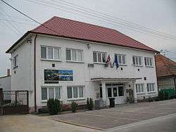
Zemianske Sady
Zemianske Sady (old form: Nemeškert; Hungarian: Nemeskürt) is a village and municipality in Galanta District of the Trnava Region of south-west Slovakia.
Zemianske Sady | |
|---|---|
Municipality | |
 | |
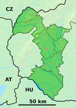 Zemianske Sady Location of Zemianske Sady in the Trnava Region  Zemianske Sady Zemianske Sady (Slovakia) | |
| Coordinates: 48°20′N 17°49′E | |
| Country | Slovakia |
| Region | Trnava |
| District | Galanta |
| First mentioned | 1156 |
| Area | |
| • Total | 8.053 km2 (3.109 sq mi) |
| Elevation | 150 m (490 ft) |
| Population | |
| • Total | 880 |
| • Density | 110/km2 (280/sq mi) |
| Time zone | UTC+1 (CET) |
| • Summer (DST) | UTC+2 (CEST) |
| Postal code | 925 54 |
| Area code(s) | 421-31 |
| Car plate | GA |
| Website | zemianskesady.sk |
History
In historical records the village was first mentioned in 1156.
Geography
The municipality lies at an altitude of 150 metres and covers an area of 8.053 km². It has a population of about 880 people.
People
- Benjamin Szold, father of Henrietta Szold
External links
![]()
- Official website
- https://web.archive.org/web/20071116010355/http://www.statistics.sk/mosmis/eng/run.html
This article is issued from Wikipedia. The text is licensed under Creative Commons - Attribution - Sharealike. Additional terms may apply for the media files.