Zabol
Zabol (Persian: ![]()
Zabol زابل Zābul | |
|---|---|
City | |
 | |
 Zabol | |
| Coordinates: 31°01′43″N 61°30′04″E | |
| Country | |
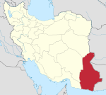
| Province | Sistan and Baluchestan |
| County | Zabol |
| Bakhsh | Central |
| Population (2016 Census) | |
| • Urban | 134,950 [1] |
| Time zone | UTC+3:30 (IRST) |
| • Summer (DST) | UTC+4:30 (IRDT) |
Zabol is located near Lake Hamun and the region is irrigated by the Helmand River. Lake Hamun is a seasonal lake that is often dry. The people of Zabol are predominantly Persians who speak a variant of the Persian language and known as Sistani or Seistani which is very similar to Dari, also known as Afghan Persian, and a minority of Baloch who speak Balochi, a Northwestern Iranian language.
The city is home to Zabol University, the largest university in the city, as well as the Zabol Medical Science University. Zabol has a regional airport.
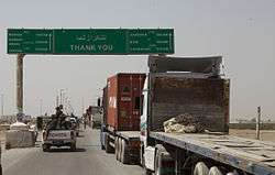
Zabol is connected by road to Zaranj across the border in Afghanistan. The Delaram-Zaranj Highway provides road connectivity to the rest of Afghanistan. Zabol thus provides Afghanistan access to the Arabian Sea and Persian Gulf via the Port of Chabahar.
Air pollution
The Zabol area is well known for its "120-day wind" (bād-e sad-o-bist-roz), a highly persistent dust storm in the summer which blows from north to south. The disappearance in the 2000s of the nearby Hamoun wetlands has exacerbated the dusty conditions in Zabol,[5] leading the World Health Organization to name Zabol the most polluted city in the world in 2016.[6] A 2017 study in the journal Preventive Medicine suggested that the harm from 30 minutes of cycling outdoors in Zabol's polluted air would outweigh the benefits of the exercise.[7]
Climate
Zabol has a hot desert climate (Köppen climate classification BWh).
| Climate data for Zabol (1962–2010) | |||||||||||||
|---|---|---|---|---|---|---|---|---|---|---|---|---|---|
| Month | Jan | Feb | Mar | Apr | May | Jun | Jul | Aug | Sep | Oct | Nov | Dec | Year |
| Record high °C (°F) | 29.0 (84.2) |
32.8 (91.0) |
38.4 (101.1) |
43.0 (109.4) |
48.0 (118.4) |
49.6 (121.3) |
49.0 (120.2) |
51.0 (123.8) |
46.8 (116.2) |
42.0 (107.6) |
36.0 (96.8) |
29.0 (84.2) |
51.0 (123.8) |
| Average high °C (°F) | 15.2 (59.4) |
18.5 (65.3) |
24.6 (76.3) |
31.7 (89.1) |
36.6 (97.9) |
40.5 (104.9) |
41.7 (107.1) |
40.0 (104.0) |
36.1 (97.0) |
30.5 (86.9) |
23.4 (74.1) |
17.2 (63.0) |
29.7 (85.5) |
| Daily mean °C (°F) | 8.5 (47.3) |
11.5 (52.7) |
17.1 (62.8) |
23.7 (74.7) |
28.9 (84.0) |
33.0 (91.4) |
34.8 (94.6) |
33.1 (91.6) |
28.4 (83.1) |
22.2 (72.0) |
15.3 (59.5) |
9.9 (49.8) |
22.2 (72.0) |
| Average low °C (°F) | 1.8 (35.2) |
4.4 (39.9) |
9.5 (49.1) |
15.7 (60.3) |
21.1 (70.0) |
25.4 (77.7) |
27.8 (82.0) |
26.1 (79.0) |
20.6 (69.1) |
13.9 (57.0) |
7.2 (45.0) |
2.7 (36.9) |
14.7 (58.5) |
| Record low °C (°F) | −12.0 (10.4) |
−9.0 (15.8) |
−2.2 (28.0) |
3.0 (37.4) |
7.2 (45.0) |
14.0 (57.2) |
19.0 (66.2) |
12.0 (53.6) |
6.0 (42.8) |
0.0 (32.0) |
−4.0 (24.8) |
−7.0 (19.4) |
−12.0 (10.4) |
| Average precipitation mm (inches) | 13.8 (0.54) |
12.8 (0.50) |
14.3 (0.56) |
4.8 (0.19) |
0.8 (0.03) |
0.1 (0.00) |
0.0 (0.0) |
0.0 (0.0) |
0.0 (0.0) |
1.6 (0.06) |
2.2 (0.09) |
7.3 (0.29) |
57.7 (2.27) |
| Average precipitation days (≥ 1.0 mm) | 2.6 | 2.4 | 2.8 | 1.3 | 0.3 | 0.0 | 0.0 | 0.0 | 0.0 | 0.2 | 0.6 | 1.4 | 11.6 |
| Average relative humidity (%) | 57 | 52 | 46 | 39 | 30 | 25 | 23 | 22 | 24 | 32 | 43 | 53 | 37 |
| Mean monthly sunshine hours | 198.8 | 203.1 | 225.0 | 264.2 | 310.0 | 321.0 | 324.4 | 317.0 | 288.3 | 288.2 | 235.9 | 198.5 | 3,174.4 |
| Source: Iran Meteorological Organization (records),[8] (temperatures),[9] (precipitation),[10] (humidity),[11] (days with precipitation),[12]
(sunshine)[13] | |||||||||||||
Colleges and Universities

- Zabol University
- Zabol University of Medical Sciences
- Islamic Azad university, Zabol Branch
- Payame-noor university of Zabol
References
- https://www.amar.org.ir/english
- Zabol can be found at GEOnet Names Server, at this link, by opening the Advanced Search box, entering "-3781433" in the "Unique Feature Id" form, and clicking on "Search Database".
- Skrine, Clarmont (1962). World War In Iran. Constable & Company. p. 68.
- "Census of the Islamic Republic of Iran, 1385 (2006)". Islamic Republic of Iran. Archived from the original (Excel) on 2011-11-11.
- Vidal, John; Kamali, Saeed (May 12, 2016). "Which are the world's two most polluted cities – and why?". The Guardian. London. Retrieved February 14, 2017.
- Miles, Tom (May 12, 2016). "Iranian, Indian cities ranked worst for air pollution". Reuters. Retrieved February 14, 2017.
- Van Mead, Nick (February 13, 2017). "Tipping point: revealing the cities where exercise does more harm than good". The Guardian. Retrieved February 14, 2017.
-
- "Highest record temperature in Zabol by Month 1962–2010". Iran Meteorological Organization. Retrieved April 8, 2015.
- "Lowest record temperature in Zabol by Month 1962–2010". Iran Meteorological Organization. Retrieved April 8, 2015.
-
- "Average Maximum temperature in Zabol by Month 1962–2010". Iran Meteorological Organization. Retrieved April 8, 2015.
- "Average Mean Daily temperature in Zabol by Month 1962–2010". Iran Meteorological Organization. Retrieved April 8, 2015.
- "Average Minimum temperature in Zabol by Month 1962–2010". Iran Meteorological Organization. Retrieved April 8, 2015.
- "Monthly Total Precipitation in Zabol by Month 1962–2010". Iran Meteorological Organization. Retrieved April 8, 2015.
- "Average relative humidity in Zabol by Month 1962–2010". Iran Meteorological Organization. Retrieved April 8, 2015.
- "No. Of days with precipitation equal to or greater than 1 mm in Zabol by Month 1962–2010". Iran Meteorological Organization. Retrieved April 8, 2015.
- "Monthly total sunshine hours in Zabol by Month 1962–2010". Iran Meteorological Organization. Retrieved April 8, 2015.
External links
![]()