Yelets
Yelets (Russian: Еле́ц) is a city in Lipetsk Oblast, Russia, situated on the Bystraya Sosna River, which is a tributary of the Don. Population: 108,404 (2010 Census);[3] 116,726 (2002 Census);[8] 120,261 (1989 Census).[9]
Yelets Елец | |
|---|---|
City[1] | |
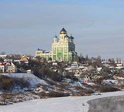 Yelets Cathedral | |
.png) Flag .png) Coat of arms | |
Location of Yelets 
| |
 Yelets Location of Yelets 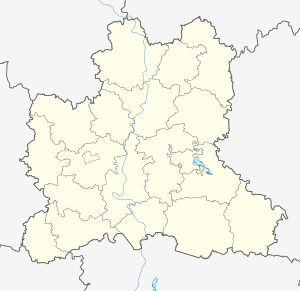 Yelets Yelets (Lipetsk Oblast) | |
| Coordinates: 52°37′00″N 38°28′00″E | |
| Country | Russia |
| Federal subject | Lipetsk Oblast[1] |
| First mentioned | 1146 |
| Government | |
| • Head | Sergey Panov |
| Area | |
| • Total | 70.67 km2 (27.29 sq mi) |
| Elevation | 140 m (460 ft) |
| Population | |
| • Total | 108,404 |
| • Estimate (2018)[4] | 104,349 (-3.7%) |
| • Rank | 151st in 2010 |
| • Density | 1,500/km2 (4,000/sq mi) |
| • Subordinated to | Yelets City Under Oblast Jurisdiction[1] |
| • Capital of | Yeletsky District[1], Yelets City Under Oblast Jurisdiction[1] |
| • Urban okrug | Yelets Urban Okrug[5] |
| • Capital of | Yelets Urban Okrug[5], Yeletsky Municipal District[5] |
| Time zone | UTC+3 (MSK |
| Postal code(s)[7] | 399770—399788 |
| Dialing code(s) | +7 47467 |
| OKTMO ID | 42715000001 |
| Website | elets-adm |
History
Yelets is the oldest center of the Central Black Earth Region. It was mentioned in historical documents as early as 1146 or 1147, when it was a fort belonging to the Princes of Ryazan.[10] The town's position at the very south of Russian lands made it an easy prey for Turkic conquerors. The Mongols burned it in 1239,[10] Uzbeg Khan ravaged it in 1316, Timur sacked it in 1395, and the Tatars devastated it in 1414.
In 1483, the Principality of Yelets was absorbed by the Grand Duchy of Moscow, while the local Rurikid rulers (last heard of in the 19th century) entered the service of Ivan III. In 1591, Boris Godunov revived the largely deserted town by establishing a fortress there. In 1618, the fortress was captured "by subterfuge" by 20,000 Cossacks under Petro Konashevych-Sahaidachny, allied with Władysław IV of Poland. They dismantled a large part of town fortifications.
In the 19th century, Yelets became the largest trade center of the region. Handmade lace has been a notable product of the city since then; other important industries are grain milling and the manufacture of machinery. The town's chief landmark is the vast Ascension Cathedral, built over the years 1845–1889 to a Neo-Muscovite design by Konstantin Thon. The town was occupied by the German Army from December 4 to 9, 1941 and damaged during the brief occupation and Soviet offensive in the region.
Administrative and municipal status
Within the framework of administrative divisions, Yelets serves as the administrative center of Yeletsky District, even though it is not a part of it.[1] As an administrative division, it is incorporated as Yelets City Under Oblast Jurisdiction—an administrative unit with a status equal to that of the districts.[1] As a municipal division, Yelets City Under Oblast Jurisdiction is incorporated as Yelets Urban Okrug.[5]
Economy and transportation
The city is connected to Moscow, Lipetsk, Oryol, and Rostov by rail and the M4 highway runs past it.
The main industries are limestone quarrying, engineering, food processing, textiles and clothing (Yelets Lace), tobacco processing, and vodka distilling.
Culture and education
The city has a theatre, cinemas, and several sports venues.
The Yelets State University was upgraded from an institute in 2000 and the city has eight secondary schools.
Notable people
- Iulia Dombrovskaia, pediatrician born in Yelets in 1891.
References
Notes
- Law #382-OZ
- http://www.gks.ru/scripts/db_inet2/passport/table.aspx?opt=42701000200620072008200920102011.
- Russian Federal State Statistics Service (2011). "Всероссийская перепись населения 2010 года. Том 1" [2010 All-Russian Population Census, vol. 1]. Всероссийская перепись населения 2010 года [2010 All-Russia Population Census] (in Russian). Federal State Statistics Service.
- "26. Численность постоянного населения Российской Федерации по муниципальным образованиям на 1 января 2018 года". Federal State Statistics Service. Retrieved January 23, 2019.
- Law #536-OZ
- "Об исчислении времени". Официальный интернет-портал правовой информации (in Russian). June 3, 2011. Retrieved January 19, 2019.
- Почта России. Информационно-вычислительный центр ОАСУ РПО. (Russian Post). Поиск объектов почтовой связи (Postal Objects Search) (in Russian)
- Russian Federal State Statistics Service (May 21, 2004). "Численность населения России, субъектов Российской Федерации в составе федеральных округов, районов, городских поселений, сельских населённых пунктов – районных центров и сельских населённых пунктов с населением 3 тысячи и более человек" [Population of Russia, Its Federal Districts, Federal Subjects, Districts, Urban Localities, Rural Localities—Administrative Centers, and Rural Localities with Population of Over 3,000] (XLS). Всероссийская перепись населения 2002 года [All-Russia Population Census of 2002] (in Russian).
- "Всесоюзная перепись населения 1989 г. Численность наличного населения союзных и автономных республик, автономных областей и округов, краёв, областей, районов, городских поселений и сёл-райцентров" [All Union Population Census of 1989: Present Population of Union and Autonomous Republics, Autonomous Oblasts and Okrugs, Krais, Oblasts, Districts, Urban Settlements, and Villages Serving as District Administrative Centers]. Всесоюзная перепись населения 1989 года [All-Union Population Census of 1989] (in Russian). Институт демографии Национального исследовательского университета: Высшая школа экономики [Institute of Demography at the National Research University: Higher School of Economics]. 1989 – via Demoscope Weekly.
- Chisholm, Hugh, ed. (1911). . Encyclopædia Britannica. 9 (11th ed.). Cambridge University Press. p. 262.
Sources
- Липецкий областной Совет депутатов. Закон №382-ОЗ от 28 апреля 2010 г. «Об административно-территориальном устройстве Липецкой области и порядке его изменения», в ред. Закона №343-ОЗ от 5 декабря 2014 г. «О внесении изменений в некоторые Законы Липецкой области в связи с объединением сельских поселений Добринский сельсовет и Сафоновский сельсовет Добринского муниципального района Липецкой области». Вступил в силу по истечении 10 дней со дня официального опубликования. Опубликован: "Липецкая газета", №88, 7 мая 2010 г. (Lipetsk Oblast Council of Deputies. Law #382-OZ of April 28, 2010 On the Administrative-Territorial Structure of Lipetsk Oblast and on the Procedures for Its Change, as amended by the Law #343-OZ of December 5, 2014 On Amending Various Laws of Lipetsk Oblast Due to the Merger of the Rural Settlements of Dobrinsky Selsoviet and Safonovsky Selsoviet in Dobrinsky Municipal District of Lipetsk Oblast. Effective as of the day which is 10 days after the day of the official publication.).
- Липецкий областной Совет депутатов. Закон №114-ОЗ от 2 июля 2004 г. «О наделении муниципальных образований в Липецкой области статусом городского округа, муниципального района, городского и сельского поселения», в ред. Закона №343-ОЗ от 5 декабря 2014 г. «О внесении изменений в некоторые Законы Липецкой области в связи с объединением сельских поселений Добринский сельсовет и Сафоновский сельсовет Добринского муниципального района Липецкой области». Вступил в силу со дня официального опубликования. Опубликован: "Липецкая газета", №131, 8 июля 2004 г. (Lipetsk Oblast Council of Deputies. Law #536-OZ of August 18, 2011 On Granting Urban Okrug, Municipal District, Urban and Rural Settlement Status to the Municipal Formations of Lipetsk Oblast, as amended by the Law #343-OZ of December 5, 2014 On Amending Various Laws of Lipetsk Oblast Due to the Merger of the Rural Settlements of Dobrinsky Selsoviet and Safonovsky Selsoviet in Dobrinsky Municipal District of Lipetsk Oblast. Effective as of the day of the official publication.).
Administrative center: Lipetsk • Rural localities | |||
| Districts | |||
| Cities and towns | |||
| Authority control |
|
|---|