Wyoming Highway 291
Wyoming Highway 291 (WYO 291) is a 9.46-mile-long (15.22 km) north-south Wyoming state road located in central Park County and provides access to Buffalo Bill State Park, Buffalo Bill Dam, and Buffalo Bill Reservoir as well as other areas southwest of Cody.
| ||||
|---|---|---|---|---|
| Southfork Road | ||||
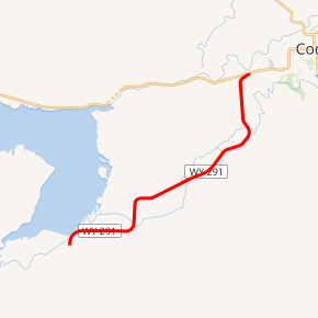
WYO 291 highlighted in red | ||||
| Route information | ||||
| Maintained by WYDOT | ||||
| Length | 9.46 mi[1] (15.22 km) | |||
| Major junctions | ||||
| South end | ||||
| North end | ||||
| Location | ||||
| Counties | Park | |||
| Highway system | ||||
State highways in Wyoming
| ||||

Route description
Wyoming Highway 291 begins its southern end at Park CR 6WX (Southfork Road) near the south end of the Buffalo Bill Reservoir, southwest of Cody.[2] Highway 291, named Southfork Road, meanders along the southeastern side of the state park and reservoir before traveling more northeast in direction toward Cody. WYO 291 then turns to head due north. At just under 9.5 miles, WYO 291 reaches its northern terminus at the Buffalo Bill Cody Scenic Byway, better known as US 14/US 16/US 20 (Yellowstone Avenue), on the west side of Cody.[3][4]
Major intersections
The entire route is in Park County.
| Location | mi[1] | km | Destinations | Notes | |
|---|---|---|---|---|---|
| | 0.00 | 0.00 | Southern terminus of WYO 291 | ||
| Cody | 9.46 | 15.22 | Northern terminus of WYO 291 | ||
| 1.000 mi = 1.609 km; 1.000 km = 0.621 mi | |||||
References
- Wyoming Department of Transportation Reference Marker Book (PDF) (Map). WYDOT. November 2004. Archived from the original (PDF) on July 17, 2011. Retrieved February 28, 2012.
- Park County Public Works - Map 52103
- Google (28 February 2012). "Overview Map of Wyoming Highway 291" (Map). Google Maps. Google. Retrieved 28 February 2012.
- Wyoming @ AARoads.com - Wyoming Routes 200-299
External links
| Wikimedia Commons has media related to Wyoming Highway 291. |