Wreck Bay Village, Jervis Bay Territory
Wreck Bay Village, formerly Wreck Bay Aboriginal Reserve, is an Aboriginal locality in the Jervis Bay Territory, Australia. At the 2011 census the population was 198.[1] It is a largely an Australian Aboriginal community, run by the Wreck Bay Aboriginal Community Council.
| Wreck Bay Village Jervis Bay Territory | |||||||||
|---|---|---|---|---|---|---|---|---|---|
 Entrance Sign to the Wreck Bay Village | |||||||||
 Wreck Bay Village | |||||||||
| Coordinates | 35°10′00″S 150°41′23″E | ||||||||
| Population | 198 (2011 census)[1] | ||||||||
| Postcode(s) | 2540 | ||||||||
| Elevation | 30 m (98 ft)[2] | ||||||||
| Time zone | AEST (UTC+10) | ||||||||
| • Summer (DST) | AEDT (UTC+11) | ||||||||
| Location |
| ||||||||
| Federal Division(s) | Fenner[3] | ||||||||
| |||||||||
Geography
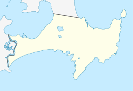
Wreck Bay Village is located at the northeast corner of Wreck Bay between the small coves called Mary Bay and Summercloud Bay. It is located in the south of the territory. It is about 2 km (1.2 mi) south of Jervis Bay Airport and 6.6 km (4.1 mi) by road from Jervis Bay Village.
History
The first European settlement around Jervis Bay started in the early 1880s. Wreck Bay forms part of the Jervis Bay Territory, and it became Commonwealth territory in 1915 so the national government based in Canberra could have access to the sea.[5]
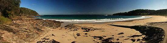
Wreck Bay is called Wreck Bay because the waves are generally quite high and it is easy for a ship to be destroyed.[6]
Aboriginal people started a small settlement at Summercloud Bay around the early 1900s. They favoured the area because of strong cultural ties, its closeness to both the bush and the sea for collection of food and other sources and because of its distance from European settlements. This area later became an Aboriginal reserve known as the Wreck Bay Aboriginal Reserve that was put under control of a mission manager. The decision to create this permanent settlement has enabled cultural practices to survive.[6]
The 402 hectares (990 acres) of land was officially handed to the Aboriginal community in 1995 by the Australian Government,[6] including the Booderee National Park and Botanic Gardens.
Booderee
The Wreck Bay Aboriginal Community owns and co-manages (with Parks Australia), the Booderee National Park and Botanic Gardens. It includes Australia's only Aboriginal-owned and managed botanic garden.[7][8][9]
Current status
The Wreck Bay Village is now private land and no public access is available.[10]
References
- Australian Bureau of Statistics (31 October 2012). "Wreck Bay". 2011 Census QuickStats. Retrieved 8 May 2013.

- Topographic map 9027 Jervis Bay
- "Fraser". Australian Electoral Commission. 21 November 2012. Retrieved 8 May 2013.
- "Jervis Bay (Point Perpendicular AWS)". Climate statistics for Australian locations. Bureau of Meteorology. Retrieved 8 May 2013.
- "European History". Australian Department of Environment and Energy. Retrieved 17 March 2017.
- "Aboriginal Culture and History". Australian Department of Environment and Energy. Retrieved 17 March 2017.
- "Welcome to Booderee National Park". Commonwealth of Australia. Retrieved 5 February 2020.
- "Aboriginal culture and history". Department of the Environment and Energy. Australia. Dept of Agriculture, Water and the Environment. Retrieved 5 February 2020.
- "Our history". Parks Australia. Retrieved 5 February 2020.
- "Booderee Map" (PDF). Parks Australia. Retrieved 17 March 2017.