Wooroonden
Wooroonden is a locality in the South Burnett Region, Queensland, Australia.[1]
| Wooroonden Queensland | |||||||||||||||
|---|---|---|---|---|---|---|---|---|---|---|---|---|---|---|---|
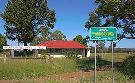 Wooroonden State School, 2011 | |||||||||||||||
 Wooroonden | |||||||||||||||
| Coordinates | 26.1130°S 151.7597°E | ||||||||||||||
| Postcode(s) | 4605 | ||||||||||||||
| Area | 33.4 km2 (12.9 sq mi) | ||||||||||||||
| LGA(s) | South Burnett Region | ||||||||||||||
| State electorate(s) | Nanango | ||||||||||||||
| Federal Division(s) | Wide Bay | ||||||||||||||
| |||||||||||||||
History
The school was originally known as Woroonden School, but on advice from the Murgon Shire Council on 24 January 2002, the locality was to be known as Wooroonden.[1]
References
- "Wooroonden - locality in South Burnett Region (entry 46284)". Queensland Place Names. Queensland Government. Retrieved 31 December 2017.
This article is issued from Wikipedia. The text is licensed under Creative Commons - Attribution - Sharealike. Additional terms may apply for the media files.