Woolwine, Virginia
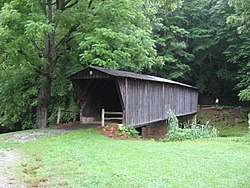
Woolwine is an unincorporated community in northern Patrick County, Virginia, United States. The western terminus of State Route 40 is here, at State Route 8. The community lies in the Rocky Knob American Viticultural Area. Two covered bridges are located in Woolwine: the Jack's Creek Covered Bridge (built 1914) and the more recent Clifford Wood Covered Bridge (built 1977) which is privately owned. They span the Smith River. The Bob White Covered Bridge (built 1921), which also spanned the Smith River, was destroyed during flooding on September 29, 2015.[2]
Woolwine | |
|---|---|
 Woolwine Location within the Commonwealth of Virginia  Woolwine Woolwine (the United States) | |
| Coordinates: 36°47′23″N 80°16′39″W | |
| Country | United States |
| State | Virginia |
| County | Patrick |
| Area | |
| • Total | 170 sq mi (430 km2) |
| Time zone | UTC−5 (Eastern (EST)) |
| • Summer (DST) | UTC−4 (EDT) |
| ZIP codes | 24185 |
| GNIS feature ID | 1500355[1] |
Woolwine has an elevation of 430 metres (1,410 ft). The community sits at the foot of the Blue Ridge Mountains.[3] The Blue Ridge Parkway is 10 kilometres (6.2 mi) northwest of Woolwine following State Route 8.[4]
Climate
The climate in this area is characterized by hot, humid summers and generally mild to cool winters. According to the Köppen Climate Classification system, Woolwine has a humid subtropical climate, abbreviated "Cfa" on climate maps.[6]
References
- U.S. Geological Survey Geographic Names Information System: Woolwine, Virginia
- Williams, Ben. "Bob White Covered Bridge washed away" (September 30, 2015). Martinsville Bulletin. Retrieved 30 September 2015.
- Google Earth
- http://www.mtnlaurel.com/backroads/147-woolwine-virginia-backroads-tour.html, accessed 24 Sep 2017
- Baseball Reference-Herb Hash
- Climate Summary for Woolwine, Virginia
External links
- Dale J. Travis Covered Bridges. VA Covered Bridges: Credits. Retrieved Nov. 12, 2007
Municipalities and communities of Patrick County, Virginia, United States | ||
|---|---|---|
| Town | 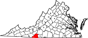 Map of Virginia highlighting Patrick County | |
| CDP | ||
| Unincorporated communities | ||