Williamnagar
Williamnagar, formerly known as Simsanggre,[1] is the headquarters of East Garo Hills district in the state of Meghalaya in India.
Williamnagar | |
|---|---|
city | |
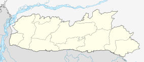 Williamnagar Location in Meghalaya, India  Williamnagar Williamnagar (India) | |
| Coordinates: 25.4954600°N 90.6168200°E | |
| Country | India |
| State | Meghalaya |
| District | East Garo Hills |
| Population (2001) | |
| • Total | 18,251 |
| Languages | |
| • Official | Garo English |
| Time zone | UTC+5:30 (IST) |
| Vehicle registration | Ml-07b 3172 |
| Climate | Cwa |
History
Williamnagar, the headquarters complex of the East Garo Hills district of Meghalaya, one of the states of North-Eastern India, was christened after Captain Williamson A. Sangma, the founding Chief Minister of the State of Meghalaya. The township was planned around the erstwhile village of Simsanggre, on the vast plainlands along the bank of the Simsang River, in 1976 after the Garo Hills district of yesteryear was re-organised to carve out a new district called East Garo Hills District.
The place where Williamnagar is situated has historical importance as it was here that the Garos made their last major resistance to the British intrusion into Garo Hills during the year 1837. The legendary Garo leader Pa Togan Nengminja Sangma was felled by the British, in skirmish, at Chisobibra, on the outskirts of Williamnagar, on 12 December 1837.
Demographics
As of 2001 India census,[2] Williamnagar had a population of 18,251. Males constitute 52% of the population and females 48%. Williamnagar has an average literacy rate of 67%, higher than the national average of 59.5%: male literacy is 71%, and female literacy is 64%. In Williamnagar, 18% of the population is under 6 years of age.
Places of interest
- Pa.Togan N Sangma Memorial Park, Chisobibra
- Simsang River
- Jadi Dare Park
- Chibok Dare(Falls)
- Mrik Wari
- Rongon (Swimming)
- Me Dare(Falls)
- Gitcham(old) Balpakram
- Bansamgre Picnic Spot
- Bansamgre Fish Sanctuary
- Nengmandal Fish Sanctuary
- Do.be Dare(Falls)
Schools and colleges
Schools
- Sacred Heart Higher Secondary School, Nengsanggre
- Rongrenggiri Govt. Higher Secondary School, Kusimkolgre
- Rongrenggiri Model Secondary School, Rongreng-Chidekgre
- Bolkinggre Secondary School, Bolkinggre
- Williamnagar Girls Secondary School, Super Market
- Peneul Secondary School, Mount Penuel
- Sunbeam Secondary School, Tambo A'ding
- Educere Higher Secondary School, Kusimkolgre
- Green Hill Secondary School, Balsrigittim
- Greenyard Secondary School, Fishery Colony
- Trinity Secondary School, Kusimkol
- Jawahar Navodaya Vidyalaya Samgong
- Williamnagar Vidya Mandir Secondary School, Super Market
- Simsanggre Secondary School, DC Old Colony
- Balsrigittim MP Secondary School, Balsrigittim
- Riverdale Secondary School, Main Bazar
- Loyola Higher Secondary School, Dawagre
- Ferrando Memorial Secondary School, New Denggagre
Colleges
- Williamnagar Govt. College, Nokgil A'we
- Ramsang College, Kusimkolgre
- Loyola College, Dobetkolgre
Localities
- Baija Kusimkol
- Baija
- Samgongre
- Damagre
- Chisobibra
- Chidekgre
- Rangmal Badim
- Kusimkolgre
- Nokil A·we
- Nengsangre
- Balsrigittim
- DC Colony
- Fishery Colony
- PWD Colony
- Kolmesalgre
- Irrigation Colony
- Main Bazar
- Cinema Hall - Super Market
- Medical Colony
- Tambo A·ding
- Dobetkolgre
- Denggagre
- Dawagre
- Warimagre
- Sampalgre
- Chiokgre
- Asiragre
- Nengmandalgre
- Chachatgre
- Rongongre
- Bolkingre
References
- "East Garo Hills town gets first IT centre". Telegraph India. 25 November 2013. Retrieved 21 April 2019.
Williamnagar, the district headquarters, though, is the only “planned town” in the entire state. It is situated on the upper reaches of the Simsang river, and for this reason it was originally called Simsanggre. The name was rechristened in 1976 to Williamnagar, after Meghalaya’s first chief minister Captain Williamson A. Sangma.
- "Census of India 2001: Data from the 2001 Census, including cities, villages and towns (Provisional)". Census Commission of India. Archived from the original on 16 June 2004. Retrieved 1 November 2008.
External links
| Topics |
|
|---|---|
| Administration |
|
| Divisions |
|
| Districts | |
| Municipalities | |
| |