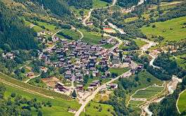
Wiler
Wiler (Lötschen) is a municipality in the district of Raron in the canton of Valais in Switzerland.
Wiler (Lötschen) | |
|---|---|
 | |
 Coat of arms | |
Location of Wiler (Lötschen) 
| |
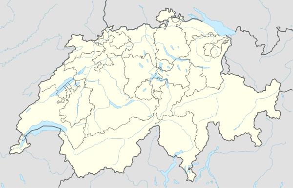 Wiler (Lötschen) Wiler (Lötschen) | |
| Coordinates: 46°23′N 7°46′E | |
| Country | Switzerland |
| Canton | Valais |
| District | Raron |
| Area | |
| • Total | 14.68 km2 (5.67 sq mi) |
| Elevation | 1,421 m (4,662 ft) |
| Population (2018-12-31)[2] | |
| • Total | 566 |
| • Density | 39/km2 (100/sq mi) |
| Postal code | 3918 |
| SFOS number | 6202 |
| Surrounded by | Blatten (Lötschen), Kandersteg (BE), Kippel, Niedergesteln, Raron |
| Website | http://www.wilervs.ch SFSO statistics |
Geography
Wiler has an area, as of 2009, of 14.7 square kilometers (5.7 sq mi). Of this area, 2.83 km2 (1.09 sq mi) or 19.3% is used for agricultural purposes, while 3.4 km2 (1.3 sq mi) or 23.2% is forested. Of the rest of the land, 0.37 km2 (0.14 sq mi) or 2.5% is settled (buildings or roads), 0.14 km2 (35 acres) or 1.0% is either rivers or lakes and 7.95 km2 (3.07 sq mi) or 54.2% is unproductive land.[3]
Of the built up area, housing and buildings made up 1.4% and transportation infrastructure made up 0.9%. Out of the forested land, 19.6% of the total land area is heavily forested and 2.5% is covered with orchards or small clusters of trees. Of the agricultural land, 0% is used for growing crops, 5.2% is pastures and 14.1% is used for alpine pastures. All the water in the municipality is flowing water. Of the unproductive areas, 13.6% is unproductive vegetation, 36.5% is too rocky for vegetation and 4.2% of the land is covered by glaciers.[3]
Coat of arms
The blazon of the municipal coat of arms is Argent, four Cynorrhodon Flowers Gules conjoined Or surrounded by a Garland and in base Coupeaux Vert.[4]
Demographics

Wiler has a population (as of December 2018) of 565.[5] As of 2008, 5.1% of the population are resident foreign nationals.[6] Over the last 10 years (2000–2010 ) the population has changed at a rate of 9.3%. It has changed at a rate of 2% due to migration and at a rate of 8.3% due to births and deaths.[7]
Most of the population (as of 2000) speaks German (479 or 98.2%) as their first language, Serbo-Croatian is the second most common (4 or 0.8%) and Danish is the third (3 or 0.6%).[8]
As of 2008, the population was made up of 522 Swiss citizens and 28 non-citizen residents (5.09% of the population).[6] Of the population in the municipality, 355 or about 72.7% were born in Wiler and lived there in 2000. There were 97 or 19.9% who were born in the same canton, while 24 or 4.9% were born somewhere else in Switzerland, and 11 or 2.3% were born outside of Switzerland.[8]
As of 2000, children and teenagers (0–19 years old) make up 21.5% of the population, while adults (20–64 years old) make up 65% and seniors (over 64 years old) make up 13.5%.[7]
As of 2000, there were 229 people who were single and never married in the municipality. There were 224 married individuals, 28 widows or widowers and 7 individuals who are divorced.[8]
As of 2000, there were 175 private households in the municipality, and an average of 2.8 persons per household.[7] There were 36 households that consist of only one person and 20 households with five or more people. In 2000, a total of 173 apartments (30.6% of the total) were permanently occupied, while 342 apartments (60.5%) were seasonally occupied and 50 apartments (8.8%) were empty.[9] As of 2009, the construction rate of new housing units was 16.3 new units per 1000 residents.[7]
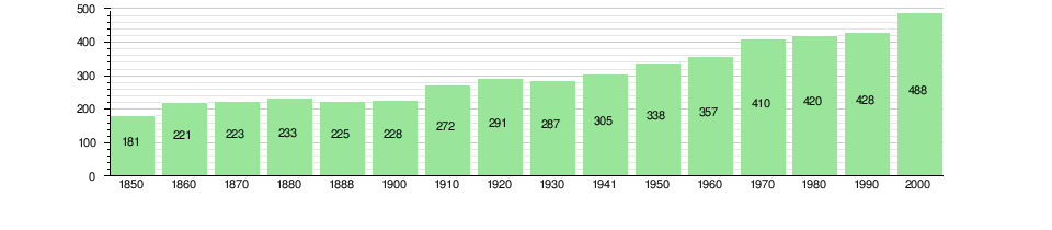
The historical population is given in the following chart:[10]
Politics
In the 2007 federal election the most popular party was the CVP which received 71.3% of the vote. The next three most popular parties were the SVP (16.64%), the Green Party (5.29%) and the SP (4.16%). In the federal election, a total of 206 votes were cast, and the voter turnout was 52.0%.[11]
Economy

As of 2010, Wiler had an unemployment rate of 1.3%. As of 2008, there were 54 people employed in the primary economic sector and about 19 businesses involved in this sector. 28 people were employed in the secondary sector and there were 8 businesses in this sector. 113 people were employed in the tertiary sector, with 28 businesses in this sector.[7] There were 255 residents of the municipality who were employed in some capacity, of which females made up 34.9% of the workforce.
In 2008 the total number of full-time equivalent jobs was 141. The number of jobs in the primary sector was 28, of which 19 were in agriculture and 9 were in forestry or lumber production. The number of jobs in the secondary sector was 26 of which 3 or (11.5%) were in manufacturing and 23 (88.5%) were in construction. The number of jobs in the tertiary sector was 87. In the tertiary sector; 14 or 16.1% were in wholesale or retail sales or the repair of motor vehicles, 18 or 20.7% were in the movement and storage of goods, 30 or 34.5% were in a hotel or restaurant, 2 or 2.3% were the insurance or financial industry, 2 or 2.3% were technical professionals or scientists, 6 or 6.9% were in education and 2 or 2.3% were in health care.[12]
In 2000, there were 46 workers who commuted into the municipality and 141 workers who commuted away. The municipality is a net exporter of workers, with about 3.1 workers leaving the municipality for every one entering.[13] Of the working population, 23.1% used public transportation to get to work, and 42.4% used a private car.[7]
Transport
Wiler lies on the road up the Lötschental valley from Steg and Goppenstein. The road passes through Wiler village and reaches its end at Fafleralp. A PostAuto bus service runs along the road, connecting the municipality to Goppenstein railway station, with some buses continuing to Steg.[14]
Religion
From the 2000 census, 472 or 96.7% were Roman Catholic, while 13 or 2.7% belonged to the Swiss Reformed Church. 1 (or about 0.20% of the population) belonged to no church, are agnostic or atheist, and 2 individuals (or about 0.41% of the population) did not answer the question.[8]
Education
In Wiler about 216 or (44.3%) of the population have completed non-mandatory upper secondary education, and 26 or (5.3%) have completed additional higher education (either university or a Fachhochschule). Of the 26 who completed tertiary schooling, 88.5% were Swiss men, 11.5% were Swiss women.[8]
As of 2000, there were 10 students in Wiler who came from another municipality, while 22 residents attended schools outside the municipality.[13]
References
- "Arealstatistik Standard - Gemeinden nach 4 Hauptbereichen". Federal Statistical Office. Retrieved 13 January 2019.
- "Ständige Wohnbevölkerung nach Staatsangehörigkeitskategorie Geschlecht und Gemeinde; Provisorische Jahresergebnisse; 2018". Federal Statistical Office. 9 April 2019. Retrieved 11 April 2019.
- Swiss Federal Statistical Office-Land Use Statistics 2009 data (in German) accessed 25 March 2010
- Flags of the World.com accessed 13-October-2011
- Swiss Federal Statistical Office - STAT-TAB, online database – Ständige und nichtständige Wohnbevölkerung nach institutionellen Gliederungen, Geburtsort und Staatsangehörigkeit (in German) accessed 23 September 2019
- Swiss Federal Statistical Office - Superweb database - Gemeinde Statistics 1981-2008 (in German) accessed 19 June 2010
- Swiss Federal Statistical Office accessed 13-October-2011
- STAT-TAB Datenwürfel für Thema 40.3 - 2000 (in German) accessed 2 February 2011
- Swiss Federal Statistical Office STAT-TAB - Datenwürfel für Thema 09.2 - Gebäude und Wohnungen (in German) accessed 28 January 2011
- Swiss Federal Statistical Office STAT-TAB Bevölkerungsentwicklung nach Region, 1850-2000 (in German) accessed 29 January 2011
- Swiss Federal Statistical Office, Nationalratswahlen 2007: Stärke der Parteien und Wahlbeteiligung, nach Gemeinden/Bezirk/Canton (in German) accessed 28 May 2010
- Swiss Federal Statistical Office STAT-TAB Betriebszählung: Arbeitsstätten nach Gemeinde und NOGA 2008 (Abschnitte), Sektoren 1-3 (in German) accessed 28 January 2011
- Swiss Federal Statistical Office - Statweb (in German) accessed 24 June 2010
- "Gampel-Steg–Hohtenn–Goppenstein–Blatten (Lötschen)–Fafleralp" (PDF). Bundesamt für Verkehr. Retrieved 2013-10-14.
Municipalities in the Westlich Raron District, Switzerland | ||
|---|---|---|