Whittington, Shropshire
Whittington is a village in north west Shropshire, England.
| Whittington | |
|---|---|
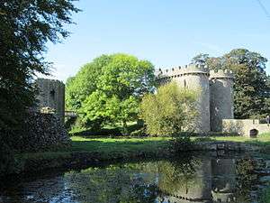 Whittington Castle | |
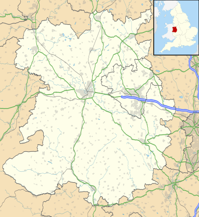 Whittington Location within Shropshire | |
| Population | 2,592 (2011) |
| OS grid reference | SJ324312 |
| Civil parish |
|
| Unitary authority | |
| Ceremonial county | |
| Region | |
| Country | England |
| Sovereign state | United Kingdom |
| Post town | OSWESTRY |
| Postcode district | SY11 |
| Dialling code | 01691 |
| Police | West Mercia |
| Fire | Shropshire |
| Ambulance | West Midlands |
| UK Parliament | |
The civil parish of Whittington had a population of 2,490 at the 2001 census, increasing to 2,592 at the 2011 census.[1] The village of Whittington is in the centre of the parish, and three smaller villages, Park Hall to its west, Hindford to the north-east and Babbinswood to the south, are also within the parish.[2]
History

Whittington appears to have inhabited since prehistoric times, and may have been a Dark Age fortress of some eminence, with an extensive settlement recorded in the Domesday Book. Whittington has been identified with Trefwen (white-town), the famous stronghold of Cynddylan king of Pengwern.
Whittington was granted to William Peverel probably in the summer of 1114 when King Henry I of England invaded Powys. William probably founded Whittington Castle which was taken from his descendants by the Welsh under Madog ap Maredudd of Powys and later granted to Roger Powys by King Henry II. It remained in the Powys family until King John granted it to the FitzWarin family, namely Fulk III FitzWarin(d.1258) whose life is recorded in a mediaeval romance.
In 1221, Henry III gave grudging permission for the castle to be re-built in stone after it had fallen to Llywelyn the Great. It was recaptured by Llywelyn in 1223 but was handed back the same year. It remained in the hands of the FitzWarins until 1420.
The castle ruins still exist today and were recently renovated. They are open to the public.
A small silver decorative brooch dating back to between 1115 and 1400 AD was discovered in a field outside Whittington in 2019.[4]
Governance
An electoral ward and an Electoral Division of the same name exists.
The ward stretches south to West Felton with a total population taken at the 2011 census of 4,067.[5]
The Electoral Division includes both Whittington Parish and West Felton Parish
Local Authorities
Shropshire Council is the Principal Authority for Whittington
The Parish Council is Whittington Parish Council
Elections
Elections are ordinarily held every four years with the principal council and the parish council on the same day.
Archive results for Shropshire Council Elections 2009-onwards
Shropshire Council 2017 election result
| Name | Party | Votes | % | winner |
|---|---|---|---|---|
| Charmley, Stephen Frank | Conservative | 613 | 53.44% | ELECTED |
| Goff, Edward David | Green | 152 | 13.25% | |
| Jones, Christopher Lee | Independent | 84 | 7.32% | |
| Walker, David | Liberal Democrats | 298 | 25.98% | |
| Total votes: | 1147 |
Parish Council 2017 election result
| Name | Party | Votes | % | winner |
|---|---|---|---|---|
| Cawthray, Andy | 362 | 9.79% | ELECTED | |
| Davis, Frank Reginald | 322 | 8.71% | ELECTED | |
| Goff, Edward David | Green | 331 | 8.95% | ELECTED |
| Harvey, Rupert Lewarne | 301 | 8.14% | ELECTED | |
| Hickman, Gregory John | 174 | 4.7% | ELECTED | |
| Hoseason, Romer Wilfred | 129 | 3.49% | ||
| Johnson, Ian | 395 | 10.68% | ELECTED | |
| Jones, Robert Paul | 333 | 9% | ELECTED | |
| Pritchard, Jennifer Elizabeth | 363 | 9.81% | ELECTED | |
| Raine, Patricia Anne | 343 | 9.27% | ELECTED | |
| Thompson-Lawrence Paul Frederick Alfred | 299 | 8.08% | ELECTED | |
| Whitby, Jill | 347 | 9.38% | ELECTED | |
| Total votes: | 3699 |
Railway service
.jpg)
Two railway stations once served Whittington. The Shrewsbury to Chester Line (via Wrexham), of the former Great Western Railway, is still an operating route, but Whittington Low Level station on this line closed on 12 September 1960 although there have been numerous campaigns over the years to have it reopened. Whittington High Level station was on the main line of the Cambrian Railways. However, the section from Whitchurch to Welshpool (Buttington Junction), via Ellesmere, Whittington, Oswestry and Llanymynech, closed on 18 January 1965 in favour of the more viable alternative route via Shrewsbury, although Whittington (High Level) station itself had closed earlier, on 4 January 1960.
Present day
Part of the Whittington parish includes Park Hall. This was previously an army training camp, but now is residential and farming land.
There is a small amount of light industry based mainly on the Whittington Business Park on the road to Oswestry. A further group of businesses operate from premises off North Drive, Park Hall. Industry and warehousing is also located at the edge of the parish, close to the main A5 road.
The largest employer within the parish is BT (previously British Telecom) which has premises on the Whittington Road.
References
- "Civil Parish population 2011". Retrieved 27 November 2015.
- "2001 Census: Key Statistics: Parish Headcounts: Area: Whittington CP (Parish)". Office for National Statistics. Retrieved 14 July 2008.
- Arms of Fulk V FitzWarin, St George's Roll of Arms, 1285, briantimms.com, St George's Roll, part 1, no. E69
- "Hoard of Roman coins and brooch found in Shropshire declared treasure". Retrieved 22 August 2019.
- "Ward population 2011". Retrieved 1 December 2015.
- P. Brown, P. King, and P. Remfry, 'Whittington Castle: The marcher fortress of the Fitz Warin family', Shropshire Archaeology and History LXXIX (2004), 106-127.
- Remfry, P.M., Whittington Castle and the families of Bleddyn ap Cynfyn, Peverel, Maminot, Powys and Fitz Warin (ISBN 1-899376-80-1)
External links
| Wikimedia Commons has media related to Whittington, Shropshire. |
| Wikivoyage has a travel guide for Whittington. |
- Info from Genuki website
- Oswestry website photos of Whittington Castle today
- BBC Shropshire feature on the castle restoration
| Unitary authorities | |
|---|---|
| Major settlements | |
| Rivers | |
| Canals | |
| Topics | |
| Authority control |
|
|---|