White Plains, Maryland
White Plains is an unincorporated community in Charles County, Maryland, in the United States, just south of Waldorf. It is at latitude 38°35'25" N, longitude 76°56'26" W. The United States Postal Service has assigned White Plains the ZIP Code 20695. While the commercial portion of White Plains lies along U.S. Route 301, the largest concentration of residences with the White Plains mailing address is six to seven miles to the west in developments near Billingsley Road. The area is experiencing population sprawl from the adjacent unincorporated communities of Waldorf and St. Charles and features new office parks and a scenic new rail trail.[2] The Charles County Department of Health is headquartered in White Plains, and a public golf course is also there. Plans to complete an east–west connector road in the area were mired in controversy because of alleged adverse effects on the environment.
White Plains, Maryland | |
|---|---|
 White Plains Location within the state of Maryland  White Plains White Plains (the United States) | |
| Coordinates: 38°35′25″N 76°56′26″W | |
| Country | United States |
| State | Maryland |
| County | Charles |
| Elevation | 197 ft (60 m) |
| Time zone | UTC-5 (Eastern (EST)) |
| • Summer (DST) | UTC-4 (EDT) |
| GNIS feature ID | 591545[1] |
The historic home Spye Park was listed on the National Register of Historic Places in 1990.[3]
References
- "White Plains". Geographic Names Information System. United States Geological Survey.
- Indian Head Rail Trail; Maryland (Rails-to-Trails Conservancy); Parks and Outdoor Sports (Charles County, Maryland)
- "National Register Information System". National Register of Historic Places. National Park Service. April 15, 2008.
See also
Municipalities and communities of Charles County, Maryland, United States | ||
|---|---|---|
| Towns | 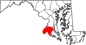 | |
| CDPs | ||
| Other communities | ||