Whangamatā
The town of Whangamatā is sited on the southeast coast of the Coromandel Peninsula in the North Island of New Zealand. It is located 30 kilometres north of Waihi, to the north of the western extremity of the Bay of Plenty.
Whangamatā | |
|---|---|
 Whangamatā | |
| Coordinates: 37°12′50″S 175°52′19″E | |
| Country | New Zealand |
| Region | Waikato |
| District | Thames-Coromandel District |
| Population (June 2019)[1] | |
| • Total | 4,060 |
| Postcode(s) | 3620 |
The population of Whangamatā was 3471 in the 2013 Census, a decrease of 84 from 3555 in the 2006 Census.[2] In holiday times the population swells considerably: New Year's celebrations fill the town to over 25,000 though this falls soon after New Year's Day.[3]
A number of off-shore islands can be seen from the beach. Hauturu or Clark Island is accessible by wading at low tide and is popular in summer months for rock-pool fossickers and kayakers. Whenuakura, sometimes known as Donut Island, sits about a kilometre east of the southern part of Whangamatā beach (Otahu Beach). Tuatara roamed on Whenuakura until fairly recently. Whenuakura Island has a large collapsed blow hole which has formed a small beach inside the island - hence the alternative name.
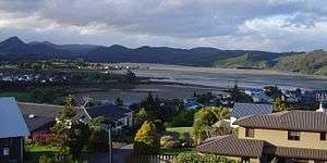
The town has two ocean beaches, both of which are extremely safe for swimming and surfing. There is a safe boating harbour at the North end of the town and another estuary at the South end. 15 minutes drive south of Whangamata is the quietly popular beach Whiritoa. Other beaches just north of Whangamatā are Onemana and Opoutere.
Place name
The Maori name 'Whangamatā' comes from the words 'whanga', which means bay, and 'matā', which means a hard stone, in reference to the obsidian which washes up on the beach.
Education
Whangamata Area School is a coeducational composite (year 1–13) school with a roll of approximately 531 students.[4]
Marina

A controversial marina has been constructed on the Whangamata Estuary. The Whangamata estuary is the shallowest on the North Island, with approximately 75% of the estuary’s water volume leaving on the low tide. The new marina basin at low tide is below sea level. Since the consent was granted, many new, and non-notified consents have been granted, including that the boat channel no longer has to be rock walled, meaning that a great deal more marine material is to be permanently removed from the estuary's sedimentary cycle. Surfers, environmentalists and Māori have opposed the marina due to the effects upon a major wetland area and the risk to a world-class left hand surf break. An Environment Court hearing stipulated that the marina could go ahead as long as certain conditions were met. Chris Carter, a former Minister of Conservation, blocked the development but his decision was judicially reviewed by the marina developers.
The decision was sent back to Conservation Minister Chris Carter, who stated that in the interests of transparency he would then give the final decision to Environment Minister David Benson-Pope, who allowed the marina to go ahead provided that strict conditions were met regarding containment of dredged materials during construction and monitoring of the world-famous surf break at the estuary's entrance. Several rare species were displaced or exterminated for the development, including the rare Oligosoma moco skink. The marina opened in November 2009.
In May 2012 a meeting of local surfers and Coastal processes scientists concluded that the Whangamata Bar had degraded for the sport of surfing, soon after the Surfbreak Protection Society released a Report citing that the Bar monitoring plan enlisted by the council was not capable of detecting changes to the Whangamata Bar, because Maintenance dredging events were not correlated with The Bar monitoring surveys.
Even so, the surveys were showing a degraded surfing quality on the Bar. The Whangamata Bar is Protected under the New Zealand Coastal Policy Statement 2010, yet to date the Local Authority, Waikato Regional Council (WRC)state that there is not enough science to prove that the degradation is caused by the marina or some other natural phenomena.
However, while WRC acknowledges that the Whangamata Bar has degraded, WRC appear unwilling to enforce the Marina developers to conduct the appropriate science to ascertain the cause.
The Environmental Defence Society has offered to host a workshop (without prejudice) to find positive outcomes. To date, the Waikato regional Council have not taken up this offer, which may mean that further court action could follow.[5]
See also
References
- "Subnational Population Estimates: At 30 June 2019". Statistics New Zealand. 22 October 2019. Retrieved 11 January 2020.
- 2013 Census QuickStats about a place : Whangamatā
- Mathew Grocott (4 February 2008). "Whangamata loses its swell". Hauraki Herald. Archived from the original on 14 February 2008.
- "New Zealand Schools Directory". New Zealand Ministry of Education. Retrieved 26 April 2020.
- "Controversial Whangamata marina opens". Stuff. NZPA. 22 November 2009. Retrieved 3 December 2011.
External links
| Wikimedia Commons has media related to Whangamata. |