Westmorland Parish, New Brunswick
Westmorland is a Canadian parish in Westmorland County, New Brunswick.[2]
Westmorland | |
|---|---|
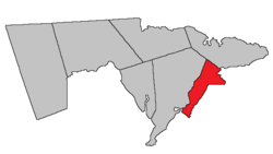 Location within Westmorland County, New Brunswick. | |
| Coordinates: 46.19°N 64.60°W | |
| Country | |
| Province | |
| County | Westmorland County |
| Established | 1805 |
| Area | |
| • Land | 175.43 km2 (67.73 sq mi) |
| Population (2016)[1] | |
| • Total | 908 |
| • Density | 5.2/km2 (13/sq mi) |
| • Change 2011-2016 | |
| • Dwellings | 596 |
| Time zone | UTC-4 (AST) |
| • Summer (DST) | UTC-3 (ADT) |
History
The parish was established in 1786 and named after Westmorland, England. It included a small part of Shediac Parish until 1827.
Delineation
Westmorland Parish is defined in the Territorial Division Act[3] as being bounded:
- Southeast by the Province limits; west by Sackville Parish; east by the Cumberland Grant line aforesaid and Baie Verte.
Communities
Parish population total does not include incorporated municipalities (in bold):
|
|
|
Demographics
Population
|
LanguageMother tongue (2016)[1]
| ||||||||||||||||||||||||||||||||||||||||||
Access routes
Highways and numbered routes that run through the parish, including external routes that start or finish at the parish limits:[6]
|
|
|
|
See also
References
- "Census Profile, 2016 Census: Westmorland, Parish [Census subdivision], New Brunswick". Statistics Canada. Retrieved October 5, 2019.
- "Westmorland Parish". New Brunswick Provincial Archives.
- "Territorial Division Act (R.S.N.B. 1973, c. T-3)". Government of New Brunswick website. Retrieved 30 August 2016.
- Statistics Canada: 2001, 2006 census
- 2011 Statistics Canada Census Profile: Westmorland Parish, New Brunswick
- Atlantic Canada Back Road Atlas ISBN 978-1-55368-618-7
Places adjacent to Westmorland Parish, New Brunswick | ||||||||||
|---|---|---|---|---|---|---|---|---|---|---|
| ||||||||||
| Subdivisions |
|
|---|---|
| Cities | |
| Counties | |
| |
This article is issued from Wikipedia. The text is licensed under Creative Commons - Attribution - Sharealike. Additional terms may apply for the media files.