West Point Township, White County, Indiana
West Point Township is one of twelve townships in White County, Indiana, United States. As of the 2010 census, its population was 381 and it contained 141 housing units.[1]
West Point Township | |
|---|---|
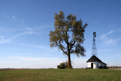 A windmill in southwestern West Point Township | |
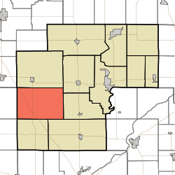 Location in White County | |
| Coordinates: 40°41′26″N 87°01′02″W | |
| Country | United States |
| State | Indiana |
| County | White |
| Government | |
| • Type | Indiana township |
| Area | |
| • Total | 53.6 sq mi (139 km2) |
| • Land | 53.53 sq mi (138.6 km2) |
| • Water | 0.07 sq mi (0.2 km2) 0.13% |
| Elevation | 722 ft (220 m) |
| Population (2010) | |
| • Total | 381 |
| • Density | 7.1/sq mi (2.7/km2) |
| ZIP codes | 47929, 47980, 47995 |
| GNIS feature ID | 454049 |
West Point Township was organized in 1845, and was named for a large tract of forest in the western part.[2]
Geography
According to the 2010 census, the township has a total area of 53.6 square miles (139 km2), of which 53.53 square miles (138.6 km2) (or 99.87%) is land and 0.07 square miles (0.18 km2) (or 0.13%) is water.[1]
Adjacent townships
- Princeton Township (north)
- Honey Creek Township (northeast)
- Big Creek Township (east)
- Prairie Township (southeast)
- Round Grove Township (south)
- Pine Township, Benton County (southwest)
- Gilboa Township, Benton County (west)
Cemeteries
The township contains West Point Cemetery. Near the back of this cemetery is a marker for Alexander Lawrie, a northern captain in the Civil War and an artist of the Hudson River School. The market claims that Lawrie made a gift to the Indiana Museum of a set of 100 paintings of Civil War generals.
School districts
- Frontier School Corporation
- Tri-County School Corporation
Political districts
- Indiana's 4th congressional district
- State House District 15
- State Senate District 07
References
- United States Census Bureau 2007 TIGER/Line Shapefiles
- United States Board on Geographic Names (GNIS)
- IndianaMap
- "Population, Housing Units, Area, and Density: 2010 - County -- County Subdivision and Place -- 2010 Census Summary File 1". United States Census. Archived from the original on 2020-02-12. Retrieved 2013-05-10.
- Hamelle, W. H. (1915). A Standard History of White County, Indiana: An Authentic Narrative of the Past, with an Extended Survey of Modern Developments in the Progress of Town and Country. Unigraphic. p. 278.
External links
Municipalities and communities of White County, Indiana, United States | ||
|---|---|---|
| City | Map of Indiana highlighting White County | |
| Towns | ||
| Townships | ||
| CDPs | ||
| Other unincorporated communities | ||