Wells, Nevada
Wells is a small city in Elko County, in northeast Nevada in the western United States. The population was 1,292 at the 2010 census. Wells is located at the junction of Interstate 80 and U.S. Route 93, approximately 50 miles (80 km) east of Elko and is part of the Elko micropolitan area.
Wells | |
|---|---|
.jpg) Wells, Nevada | |
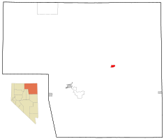 Location of Elko County in Nevada and location of Wells in Elko County | |
| Coordinates: 41°6′34″N 114°58′8″W | |
| Country | United States |
| State | Nevada |
| County | Elko |
| Area | |
| • Total | 6.9 sq mi (17.8 km2) |
| • Land | 6.9 sq mi (17.8 km2) |
| • Water | 0.0 sq mi (0.0 km2) |
| Elevation | 5,630 ft (1,716 m) |
| Population (2010) | |
| • Total | 1,292 |
| • Estimate (2018)[1] | 1,246 |
| • Density | 190/sq mi (73/km2) |
| Time zone | UTC-8 (Pacific (PST)) |
| • Summer (DST) | UTC-7 (PDT) |
| ZIP code | 89835 |
| Area code(s) | 775 |
| FIPS code | 32-83000 |
| GNIS feature ID | 0845730 |
Nevada Historical Marker | |
| Official name | Humboldt Wells |
| Reference no. | 45 |
History
The site of Wells began as a place called Humboldt Wells along the trail to California.[2] It was subsequently founded as a railroad town along the original Transcontinental Railroad, and was once a stopover for passenger trains. The Humboldt River has its source in springs and a swampy area just west of the city that today is called Humboldt Wells. In the late 19th century, Humboldt Wells was burning down, and in a frantic plea for help, a telegraph was sent that said, "Wells is burning". After this the town was rebuilt and simply referred to as 'Wells'.

The Lone Star Motel located in Wells was used in the 2001 film Joy Ride for a critical scene.
A magnitude 6.0 earthquake occurred near Wells at 6:16 A.M. on February 21, 2008. Because of its proximity to the epicenter, Wells experienced significant damage. The earthquake originated 9 km below the surface, with its epicenter only 12 miles (19 km) distant from Wells, at 41.077, 114.752.[3]
Wells is home to Bella's Gentlemen's Club, one of the legal brothels in Nevada.[4]
Geography
_near_Wells_Avenue_in_Wells%2C_Nevada.jpg)
According to the United States Census Bureau, the city has a total area of 6.9 square miles (18 km2), all land, at an elevation of 5,630 feet (1,720 m).
Wells is located by the intersection of Interstate 80 and U.S. Route 93.
Demographics
| Historical population | |||
|---|---|---|---|
| Census | Pop. | %± | |
| 1880 | 243 | — | |
| 1890 | 254 | 4.5% | |
| 1900 | 440 | 73.2% | |
| 1910 | 598 | 35.9% | |
| 1920 | 521 | −12.9% | |
| 1930 | 655 | 25.7% | |
| 1940 | 830 | 26.7% | |
| 1950 | 947 | 14.1% | |
| 1960 | 1,071 | 13.1% | |
| 1970 | 1,081 | 0.9% | |
| 1980 | 1,218 | 12.7% | |
| 1990 | 1,256 | 3.1% | |
| 2000 | 1,346 | 7.2% | |
| 2010 | 1,292 | −4.0% | |
| Est. 2018 | 1,246 | [1] | −3.6% |
| source:[5][6] | |||
At the 2000 census there were 1,346 people in 525 households, including 352 families, in the city. The population density was 195.6 people per square mile (75.5/km²). There were 633 housing units at an average density of 92.0 per square mile (35.5/km²). The racial makeup of the city was 80.24% White, 6.76% Native American, 0.30% Asian, 0.15% Pacific Islander, 9.06% from other races, and 3.49% from two or more races. Hispanic or Latino of any race were 19.47%.[7]
Of the 525 households 35.4% had children under the age of 18 living with them, 52.6% were married couples living together, 9.7% had a female householder with no husband present, and 32.8% were non-families. 28.8% of households were one person and 9.5% were one person aged 65 or older. The average household size was 2.56 and the average family size was 3.14.
The age distribution was 29.3% under the age of 18, 7.6% from 18 to 24, 27.9% from 25 to 44, 25.0% from 45 to 64, and 10.3% 65 or older. The median age was 36 years. For every 100 females, there were 107.7 males. For every 100 females age 18 and over, there were 106.5 males.
The median household income was $35,870 and the median family income was $41,827. Males had a median income of $31,250 versus $20,852 for females. The per capita income for the city was $16,835. About 8.6% of families and 11.9% of the population were below the poverty line, including 18.9% of those under age 18 and 2.1% of those age 65 or over.
Education
Public education in Wells is administered by Elko County School District. The district operates one elementary school and Wells High School.
Wells has a public library, a branch of the Elko-Lander-Eureka County Library System.[8]
References
- "Population and Housing Unit Estimates". Retrieved February 5, 2020.
- Federal Writers' Project (1941). Origin of Place Names: Nevada (PDF). W.P.A. p. 30.
- "Wells Quake - USGS". Earthquake.usgs.gov. Retrieved September 12, 2013.
- "Bella's Gentlemen's Club".
- Moffatt, Riley. Population History of Western U.S. Cities & Towns, 1850-1990. Lanham: Scarecrow, 1996, 159.
- "Subcounty population estimates: Nevada 2000-2007". United States Census Bureau, Population Division. March 18, 2009. Archived from the original (CSV) on March 31, 2009. Retrieved May 9, 2009.
- "U.S. Census website". United States Census Bureau. Retrieved 2011-05-14.
- "Nevada Public Libraries". PublicLibraries.com. Retrieved 14 June 2019.
External links
![]()
- Wells Chamber of Commerce
- Elko County
- Wells Branch Library
- Early history and photos
- Wells High School
![]()
Municipalities and communities of Elko County, Nevada, United States | ||
|---|---|---|
| Cities | 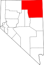 Elko County map | |
| CDPs | ||
| Other unincorporated communities |
| |
| Indian reservation | ||
| Ghost towns |
| |