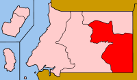
Wele-Nzas
Wele-Nzas Province is a province in the eastern portion of continental Equatorial Guinea. Its capital is Mongomo. It borders the Equatoguinean provinces of Centro Sur to the west and Kié-Ntem to the north, with Gabon's Woleu-Ntem Province to the east and south. As of 2015, the population of Wele-Nzas was 192,017.[1]
Wele-Nzas | |
|---|---|
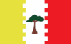 Flag | |
 | |
| Country | Equatorial Guinea |
| Capital | Mongomo |
| Area | |
| • Total | 5,478 km2 (2,115 sq mi) |
| Population (2015)[1] | |
| • Total | 192,017 |
| • Density | 35/km2 (91/sq mi) |
History
The earliest settlers of Wele-Nzas, and the only inhabitants of the region for nearly 15,000 years, were the Byele people. Bantu migration ultimately displaced the Byele, and during the 20th century the last of the Byele migrated to Cameroon. The Fang people ultimately became the predominant ethnic group in the province. As European explorers mostly avoided the interior of Equatorial Guinea, there are few accounts of the region in early European histories; even the Spanish governors of the region did not visit Wele-Nzas until the official formation of Spanish Guinea in 1926.[2]
Wele-Nzas has played an important role in post-independence Equatoguinean history as the home province of both of the country's presidents, Francisco Macías Nguema and Teodoro Obiang Nguema Mbasogo. From 1975 until the 1979 Equatorial Guinea coup d'état, Macías led his totalitarian rule of the nation from his hometown of Nsangayong on the border with Gabon. Obiang has initiated several major infrastructure projects in the province, including a new airport and conference center in Mongomo. Oyala, the planned future capital city of Equatorial Guinea, is also being built in Wele-Nzas.[2]
Geography
Mongomo is the largest city in the province; other major cities include Aconibe, Añisoc, and Nsok. A major highway links Mongomo to the port city of Bata, and a border crossing near the city connects it to the Gabonese city of Oyem.
The city of Mengomeyén is home to the province's main airport, President Obiang Nguema International Airport.
Two national parks, Altos de Nsork National Park and Monte Temelón Natural Reserve, are located within the province.[2]
References
- "Censo de población 2015–República de Guinea Ecuatorial" (PDF) (in Spanish). INEGE. p. 7. Retrieved 8 October 2017.
- Scafidi, Oscar (November 20, 2015). Equatorial Guinea. Bradt Travel Guides. pp. 193–195. ISBN 9781841629254.