Webster, Burnett County, Wisconsin
Webster is a village in Burnett County in the U.S. state of Wisconsin. The population was 653 at the 2010 census.
Webster | |
|---|---|
Village | |
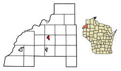 Location of Webster in Burnett County, Wisconsin. | |
 Webster Location within the state of Wisconsin | |
| Coordinates: 45°52′45″N 92°21′55″W | |
| Country | |
| State | |
| County | Burnett |
| Area | |
| • Total | 1.75 sq mi (4.54 km2) |
| • Land | 1.75 sq mi (4.54 km2) |
| • Water | 0.00 sq mi (0.00 km2) |
| Population | |
| • Total | 653 |
| • Estimate (2018)[3] | 619 |
| • Density | 353.11/sq mi (136.33/km2) |
| Time zone | UTC-6 (Central (CST)) |
| • Summer (DST) | UTC-5 (CDT) |
| ZIP codes | 54893 |
| Area code(s) | 715 & 534 |
| FIPS code | 55-85025 |
| GNIS feature ID | 1584391 |
History
The village was called Clam River until 1896, when a new post office was established and resident J.D. Rice petitioned U.S. Rep. John J. Jenkins to change the name to Webster, after lexicographer Noah Webster.[4]
Geography
Webster's absolute location is at 45°52′45″N 92°21′55″W (45.879066, -92.365163).[5] The relative location of Webster positions it south of the cities of Superior, Wisconsin and Duluth, Minnesota, Northeast of the Twin Cities Metropolitan Area in Minnesota, and Northwest of the city of Eau Claire, Wisconsin.
According to the United States Census Bureau, the village has a total area of 1.76 square miles (4.56 km2), all of it land.[6]
Demographics
| Historical population | |||
|---|---|---|---|
| Census | Pop. | %± | |
| 1920 | 399 | — | |
| 1930 | 501 | 25.6% | |
| 1940 | 524 | 4.6% | |
| 1950 | 552 | 5.3% | |
| 1960 | 514 | −6.9% | |
| 1970 | 502 | −2.3% | |
| 1980 | 610 | 21.5% | |
| 1990 | 623 | 2.1% | |
| 2000 | 653 | 4.8% | |
| 2010 | 653 | 0.0% | |
| Est. 2018 | 619 | [3] | −5.2% |
| U.S. Decennial Census[7] | |||
2010 census
As of the census[2] of 2010, there were 653 people, 308 households, and 172 families living in the village. The population density was 371.0 inhabitants per square mile (143.2/km2). There were 355 housing units at an average density of 201.7 per square mile (77.9/km2). The racial makeup of the village was 90.4% White, 1.8% African American, 3.8% Native American, 0.2% Asian, 0.9% from other races, and 2.9% from two or more races. Hispanic or Latino of any race were 2.0% of the population.
There were 308 households of which 27.9% had children under the age of 18 living with them, 31.8% were married couples living together, 17.5% had a female householder with no husband present, 6.5% had a male householder with no wife present, and 44.2% were non-families. 39.9% of all households were made up of individuals and 22.4% had someone living alone who was 65 years of age or older. The average household size was 2.12 and the average family size was 2.76.
The median age in the village was 40.3 years. 24.2% of residents were under the age of 18; 6% were between the ages of 18 and 24; 24.3% were from 25 to 44; 23.9% were from 45 to 64; and 21.6% were 65 years of age or older. The gender makeup of the village was 43.6% male and 56.4% female.
2000 census
As of the census[8] of 2000, there were 653 people, 302 households, and 176 families living in the village. The population density was 367.8 people per square mile (141.6/km²). There were 327 housing units at an average density of 184.2/sq mi (70.9/km²). The racial makeup of the village was 90.51% White, 0.46% African American, 5.05% Native American, 0.46% Asian, and 3.52% from two or more races. Hispanic or Latino of any race were 0.31% of the population.
There were 302 households out of which 28.1% had children under the age of 18 living with them, 40.4% were married couples living together, 15.6% had a female householder with no husband present, and 41.4% were non-families. 38.1% of all households were made up of individuals and 27.8% had someone living alone who was 65 years of age or older. The average household size was 2.16 and the average family size was 2.88.
In the village, the population was spread out with 25.0% under the age of 18, 8.0% from 18 to 24, 22.5% from 25 to 44, 17.2% from 45 to 64, and 27.4% who were 65 years of age or older. The median age was 40 years. For every 100 females, there were 76.0 males. For every 100 females age 18 and over, there were 75.0 males.
The median income for a household in the village was $29,432, and the median income for a family was $35,288. Males had a median income of $28,214 versus $21,500 for females. The per capita income for the village was $15,411. About 5.8% of families and 9.9% of the population were below the poverty line, including 15.4% of those under age 18 and 9.4% of those age 65 or over.
Educational institutions
The Village of Webster is included in the land of the School District of Webster. The School District of Webster includes the Webster Middle/High School, serving grades 5-12, and the Webster Elementary School, serving grades K-4. The district enrolled 655 students in 2017-2018. Webster School District covers about 550 square miles of land mostly in Burnett County with a small portion in Douglas County. It is the second largest district in the State of Wisconsin in terms of geographical area. Students come from the Village of Webster, Town of Danbury, Town of Dairyland, and several smaller townships,[9] as well as land belonging to the St. Croix Chippewa Indians of Wisconsin.[10]
Government and public office[11]
- Village President: Jeff Roberts
- Village Trustees:
- Sarah Casady
- Kelsey Gustafson
- Timothy Maloney
- Darrell Sears
- Greg Widiker
- Kevin "Charlie" Weis
- Village Clerk/Treasurer: Debra Doriott-Kuhnly
- Chief of Police: Stephenie Wedin
- Fire Chief: Alan Steiner
- Municipal Court Judge: Brian Sears
- Municipal Court Clerk: Tessa Anderson
- Public Works Director: Jay Heyer
- Assessor: Steve Nordquist
Notable citizens and natives
- Jarrod Washburn, pitcher for the Los Angeles Angels
- Mary Mack, comedian, musician, and actress
References
- "2018 U.S. Gazetteer Files". United States Census Bureau. Retrieved Feb 15, 2020.
- "U.S. Census website". United States Census Bureau. Retrieved 2012-11-18.
- "Population and Housing Unit Estimates". Retrieved June 4, 2019.
- Robert E. Gard (9 September 2015). The Romance of Wisconsin Place Names. Wisconsin Historical Society Press. ISBN 978-0-87020-708-2.
- "US Gazetteer files: 2010, 2000, and 1990". United States Census Bureau. 2011-02-12. Retrieved 2011-04-23.
- "US Gazetteer files 2010". United States Census Bureau. Retrieved 2012-11-18.
- "Census of Population and Housing". Census.gov. Retrieved June 4, 2015.
- "U.S. Census website". United States Census Bureau. Retrieved 2008-01-31.
- "Webster School District - About Webster School District". www.webster.k12.wi.us. Retrieved 2019-12-03.
- "Saint Croix Chippewa Indians of Wisconsin". Wisconsin Department of Public Instruction. 2017-09-05. Retrieved 2019-12-03.
- "Burnett County, WI - Official Website - Village of Webster". www.burnettcounty.com. Retrieved 2019-12-03.
External links
Municipalities and communities of Burnett County, Wisconsin, United States | ||
|---|---|---|
| Villages | 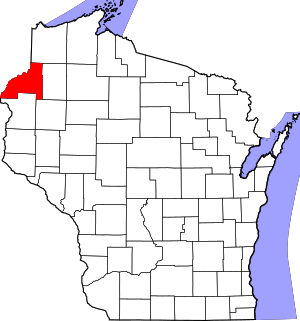 | |
| Towns | ||
| CDP | ||
| Unincorporated communities | ||
| Indian reservations | ||
| Footnotes | ‡This populated place also has portions in an adjacent county or counties | |