Waylla Ch'utu
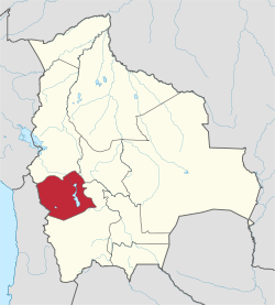
Waylla Ch'utu (Aymara waylla Stipa obtusa, a kind of feather grass, ch'utu peak of a mountain,[2][3] "Stipa obtusa peak", also spelled Huaylla Chutu) is a 4,446-metre-high (14,587 ft) mountain in the Andes of Bolivia. It is located in the Oruro Department, Challapata Province, Challapata Municipality. Waylla Ch'utu lies at the Crucero River, southwest of Llallawa.[1][4]
| Waylla Ch'utu | |
|---|---|
 Waylla Ch'utu Location in Bolivia | |
| Highest point | |
| Elevation | 4,446 m (14,587 ft) [1] |
| Coordinates | 18°53′45″S 66°34′16″W |
| Geography | |
| Location | Bolivia, Oruro Department, Challapata Province |
| Parent range | Andes |
References
- BIGM map 1:50,000 6237-II Cerro Azanaques
- Radio San Gabriel, "Instituto Radiofonico de Promoción Aymara" (IRPA) 1993, Republicado por Instituto de las Lenguas y Literaturas Andinas-Amazónicas (ILLLA-A) 2011, Transcripción del Vocabulario de la Lengua Aymara, P. Ludovico Bertonio 1612 (Spanish-Aymara-Aymara-Spanish dictionary)
- Plan de desarollo municipal Municipio de Turco
- "Challapata". ine.gob.bo. Retrieved April 20, 2016.
Capital: Oruro | ||
| Provinces |
|  |
| Municipalities (and seats) |
| |
This article is issued from Wikipedia. The text is licensed under Creative Commons - Attribution - Sharealike. Additional terms may apply for the media files.