Poopó Province
Poopó is a province in the eastern parts of the Bolivian department of Oruro. Its seat is Poopó.
Poopó | |
|---|---|
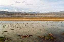 Poopó Lake with flamingos | |
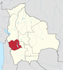
 Location of Poopó Province in Bolivia | |
| Coordinates: 18°43′S 66°37′W | |
| Country | Bolivia |
| Department | Oruro |
| Capital | Poopó |
| Area | |
| • Total | 2,034 km2 (785 sq mi) |
| Population (2001) | |
| • Total | 14,984 |
| • Density | 7.4/km2 (19/sq mi) |
| • Ethnicities | Quechua |
| Languages spoken | |
| • Spanish | 86% |
| • Quechua | 78% |
| • Aymara | 22% |
| Sectors | |
| Time zone | UTC-4 (BOT) |
Location
Poopó province is one of the sixteen provinces in the Oruro Department. It is located between 18° 15' and 18° 50' South and between 66° 19' and 66° 54' West.
The province borders Pantaléon Dalence Province in the northeast, Cercado Province in the northwest, Saucarí Province in the west, Sud Carangas Province in the southwest, Eduardo Avaroa Province in the south, and Potosí Department in the east.
The province extends over 70 km (43.5 mi) from north to south, and 70 km (43.5 mi) from east to west.
Geography
The province lies east of the Desaguadero River and Poopó Lake.
Some of the highest mountains of the province are listed below:[1][2]
|
|
|
Population
The main language of the province is Spanish, spoken by 86%. In addition to Spanish, 78% of the population speak Quechua and 22% Aymara (1992).
The population decreased from 17,437 inhabitants (1992 census) to 14,984 (2001 census), a decrease of 5.2%. - 45.2% of the population are younger than 15 years old (1992).
44% of the population have no access to electricity, 89% have no sanitary facilities (1992).
61% of the population are employed in agriculture, 12% in mining, 5% in industry, 22% in general services (2001).
86% of the population are Catholics, 12% are Protestants (1992).
Division
The province comprises three municipalities which are further subdivided into cantons.
| Section | Municipality | Seat |
|---|---|---|
| 1st | Poopó Municipality | Poopó |
| 2nd | Pazña Municipality | Pazña |
| 3rd | Antequera Municipality | Antequera |
References
- "Poopó". Retrieved October 15, 2015.
- BIGM map 1:50,000 Huanuni 6239-III
External links
Capital: Oruro | ||
| Provinces |
|  |
| Municipalities (and seats) |
| |