Warren Point, Pennsylvania
Warren Point is a former town in the southwest corner of Warren Township, Franklin County, Pennsylvania. It was located on the north side of Licking Creek, and at the southwest end of Keefer Mountain, and approximately two miles west of Yeakle Mill.
It is present on old topographic maps (for example, Hancock Quadrangle of 1899[1]), but is no longer labeled on later maps (for example, Cherry Run of 1951[2]).
The Licking Creek Member of the Old Port Formation was first described a mile east of Warren Point.
References
- Hancock Quadrangle, West Virginia-Maryland-Pennsylvania, 15 Minute Series (Topographic), 1899. U.S. Geological Survey. Scale 1:62,500.
- Cherry Run Quadrangle, West Virginia-Maryland-Pennsylvania, 7.5 Minute Series (Topographic), 1951. U.S. Geological Survey. Scale 1:24,000.
Municipalities and communities of Franklin County, Pennsylvania, United States | ||
|---|---|---|
| Boroughs | 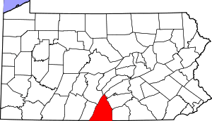 | |
| Townships | ||
| CDPs | ||
| Unincorporated communities |
| |
| Footnotes | ‡This populated place also has portions in an adjacent county or counties | |
This article is issued from Wikipedia. The text is licensed under Creative Commons - Attribution - Sharealike. Additional terms may apply for the media files.