Letterkenny Township, Franklin County, Pennsylvania
Letterkenny Township is a township in Franklin County, Pennsylvania, United States. The population was 2,318 at the 2010 census,[3] up from 2,074 at the 2000 census.
Letterkenny Township, Franklin County, Pennsylvania | |
|---|---|
 Pre-Civil War Horse Valley Bridge | |
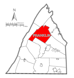 Map of Franklin County, Pennsylvania highlighting Letterkenny Township | |
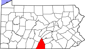 Map of Franklin County, Pennsylvania | |
| Country | United States |
| State | Pennsylvania |
| County | Franklin |
| Settled | 1736 |
| Incorporated | 1761 |
| Area | |
| • Total | 70.51 sq mi (182.62 km2) |
| • Land | 70.38 sq mi (182.28 km2) |
| • Water | 0.13 sq mi (0.35 km2) |
| Population (2010) | |
| • Total | 2,318 |
| • Estimate (2016)[2] | 2,353 |
| • Density | 33.43/sq mi (12.91/km2) |
| Time zone | UTC-5 (Eastern (EST)) |
| • Summer (DST) | UTC-4 (EDT) |
| Area code(s) | 717 |
| FIPS code | 42-055-42888 |
| Website | letterkennytownship |
History
The township is named after Letterkenny in County Donegal, Ireland. The Horse Valley Bridge, Rocky Spring Presbyterian Church, and Skinner Tavern are listed on the National Register of Historic Places.[4]
Geography
The township is in north-central Franklin County. The eastern half of the township is in the Great Appalachian Valley, while the western half occupied by the eastern two ridges of the Ridge-and-Valley Appalachians. Broad Mountain and Blue Mountain form the easternmost ridge, while Kittatinny Mountain forms the western town border. Between the two ridges is Horse Valley, drained northeastward by Conodoguinet Creek, which turns and forms the northern boundary of the township as the creek leaves the mountains and enters the Great Appalachian Valley.
The southeastern part of the township is within the Letterkenny Army Depot. North of the depot are the unincorporated communities of Upper Strasburg and Pleasant Hall.
According to the United States Census Bureau, the township has a total area of 70.5 square miles (182.6 km2), of which 70.4 square miles (182.3 km2) is land and 0.12 square miles (0.3 km2), or 0.19%, is water.[3]
Neighboring Townships
- Fannett Township (north)
- Greene Township (southeast)
- Hamilton Township (south)
- Lurgan Township (northeast)
- Metal Township (west)
- Southampton Township (east)
- St. Thomas Township (southwest)
Communities
- Pleasant Hall
- Stenger
- Upper Strasburg
Demographics
| Historical population | |||
|---|---|---|---|
| Census | Pop. | %± | |
| 2000 | 2,074 | — | |
| 2010 | 2,318 | 11.8% | |
| Est. 2016 | 2,353 | [2] | 1.5% |
| U.S. Decennial Census[5] | |||
As of the census[6] of 2000, there were 2,074 people, 783 households, and 617 families residing in the township. The population density was 29.5 people per square mile (11.4/km²). There were 829 housing units at an average density of 11.8/sq mi (4.6/km²). The racial makeup of the township was 98.07% White, 1.35% African American, 0.10% Native American, 0.10% Asian, 0.29% from other races, and 0.10% from two or more races. Hispanic or Latino of any race were 0.58% of the population.
There were 783 households, out of which 33.3% had children under the age of 18 living with them, 67.8% were married couples living together, 5.9% had a female householder with no husband present, and 21.1% were non-families. 16.9% of all households were made up of individuals, and 6.8% had someone living alone who was 65 years of age or older. The average household size was 2.65 and the average family size was 2.96.
In the township the population was spread out, with 24.5% under the age of 18, 8.9% from 18 to 24, 30.8% from 25 to 44, 24.0% from 45 to 64, and 11.9% who were 65 years of age or older. The median age was 37 years. For every 100 females there were 105.6 males. For every 100 females age 18 and over, there were 106.1 males.
The median income for a household in the township was $40,897, and the median income for a family was $44,545. Males had a median income of $30,431 versus $21,875 for females. The per capita income for the township was $18,315. About 1.8% of families and 4.7% of the population were below the poverty line, including 7.3% of those under age 18 and 5.3% of those age 65 or over.
References
- "2016 U.S. Gazetteer Files". United States Census Bureau. Retrieved Aug 13, 2017.
- "Population and Housing Unit Estimates". Retrieved June 9, 2017.
- "Geographic Identifiers: 2010 Census Summary File 1 (G001), Letterkenny township, Franklin County, Pennsylvania". American FactFinder. U.S. Census Bureau. Archived from the original on February 13, 2020. Retrieved August 9, 2016.
- "National Register Information System". National Register of Historic Places. National Park Service. July 9, 2010.
- "Census of Population and Housing". Census.gov. Retrieved June 4, 2016.
- "U.S. Census website". United States Census Bureau. Retrieved 2008-01-31.
External links
Municipalities and communities of Franklin County, Pennsylvania, United States | ||
|---|---|---|
| Boroughs | | |
| Townships | ||
| CDPs | ||
| Unincorporated communities |
| |
| Footnotes | ‡This populated place also has portions in an adjacent county or counties | |