Wang Pong District
Wang Pong (Thai: วังโป่ง, pronounced [wāŋ pòːŋ]) is a district (amphoe) in the western part of Phetchabun Province, central Thailand.
Wang Pong วังโป่ง | |
|---|---|
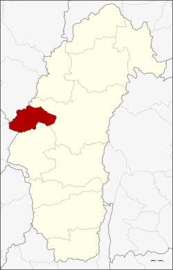 District location in Phetchabun Province | |
| Coordinates: 16°20′28″N 100°47′36″E | |
| Country | Thailand |
| Province | Phetchabun |
| Seat | Wang Pong |
| Area | |
| • Total | 543.0 km2 (209.7 sq mi) |
| Population (2005) | |
| • Total | 38,473 |
| • Density | 70.8/km2 (183/sq mi) |
| Time zone | UTC+7 (ICT) |
| Postal code | 67240 |
| Geocode | 6710 |
History
The three tambons Wang Pong, Thai Dong, and Sap Poep were separated from Chon Daen District and made a minor district (king amphoe) on 1 December 1983.[1] It was upgraded to a full district on 21 May 1990.[2]
The original name of this area was Ban Wang Din Pong.
Geography
Neighboring districts are (from the north clockwise) Mueang Phetchabun and Chon Daen of Phetchabun Province, Tap Khlo of Phichit Province, and Noen Maprang of Phitsanulok Province.
Administration
The district is divided into five sub-districts (tambons), which are further subdivided into 58 villages (mubans). There are two townships (thesaban tambons) in the district: Wang Pong and Thai Dong, each covering parts of the same-named tambons. There are a further five tambon administrative organizations (TAO).
| No. | Name | Thai name | Villages | Pop. | |
|---|---|---|---|---|---|
| 1. | Wang Pong | วังโป่ง | 11 | 10,189 | |
| 2. | Thai Dong | ท้ายดง | 13 | 8,066 | |
| 3. | Sap Poep | ซับเปิบ | 8 | 4,924 | |
| 4. | Wang Hin | วังหิน | 14 | 9,633 | |
| 5. | Wang San | วังศาล | 12 | 5,661 |
References
- ประกาศกระทรวงมหาดไทย เรื่อง แบ่งท้องที่อำเภอชนแดน จังหวัดเพชรบูรณ์ ตั้งเป็นกิ่งอำเภอวังโป่ง (PDF). Royal Gazette (in Thai). 100 (179 ง special): 4237. November 15, 1983.
- พระราชกฤษฎีกาตั้งอำเภอห้วยผึ้ง อำเภอวังวิเศษ อำเภอคลองหาด อำเภอป่าบอน อำเภอหนองหญ้าปล้อง อำเภอวังโป่ง อำเภอควนเนียง อำเภอหนองหญ้าไซ อำเภอบ้านนาเดิม อำเภอทุ่งฝน อำเภอสร้างคอม และอำเภอทองแสนขัน พ.ศ. ๒๕๓๓ (PDF). Royal Gazette (in Thai). 107 (83 ก special): 1–4. May 21, 1994.