Wallerawang
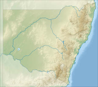
Wallerawang is a small township in the Central Tablelands of New South Wales, Australia. It is located approximately 14 kilometres (8.7 mi) northwest of Lithgow adjacent to the Great Western Highway from Sydney. It is also located on the Main Western railway line at the junction of the Gwabegar line.
| Wallerawang New South Wales | |
|---|---|
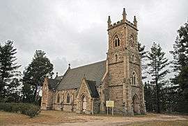 St John the Evangelist Church, built 1881 | |
 Wallerawang | |
| Coordinates | 33°24′40″S 150°03′50″E |
| Population | 1,980 (2016) |
| LGA(s) | City of Lithgow |
| Region | Central Tablelands |
| County | Australia |
| State electorate(s) | Bathurst |
| Federal Division(s) | Calare |
History
The original inhabitants of the area west of the Blue Mountains were the Wiradjuri Aboriginal Australians. It is believed they knew the area as Waller-owang. It is understood to mean place near wood and water, or plenty of water.[1] James Blackman was probably the first European to visit the area when he marked out the route of the new road from Bathurst to the area now known as Wallerawang.
In 1824, 11 years after the first exploration led by Blaxland over the Blue Mountains, a James Walker was granted a large portion of land in the area now known as Wallerawang. In 1836 the property was to become known as Barton Park.
Two of Walker's convict servants took up land leases in the area in the 1850s, one of them was Maddox who named his lease Lidsdale.
Charles Darwin, the English naturalist, stayed at "Wallerowang House" (later to become Barton Park) in 1836. Darwin describes the countryside around the Wallerawang area and the wildlife including Platypus in his book "The Voyage of the Beagle".[2]
The local school has operated at three sites, in 1860 the first small stone school opened near the present power station, in 1882 the school relocated nearer the township and finally to its present location near Lake Wallace in 1995. The 1860 school, which is still standing, was opened by James Walker's widow.
The Church of St John the Evangelist, built in 1881, was financed by private funding.[3] It was designed by architect Edmund Blacket, and is listed on the New South Wales State Heritage Register.[4]
Heritage listings
Wallerawang has a number of heritage-listed sites, including:
- Main Street: St John the Evangelist Church, Wallerawang[4]
- Main Western railway: Coxs River railway bridges, Wallerawang[5]
- Main Western railway: Wallerawang railway station[6]
Railway
The Main Western railway line passes through the town of Wallerawang. In 1870 the track was opened to Wallerawang on its way to the next temporary terminus at Rydal later in 1870 and then Tarana in 1872. The railway station closed during the early 1990s.[7]
| Preceding station | NSW Main lines | Following station | ||
|---|---|---|---|---|
Rydal towards Bourke | Main Western Line | Marrangaroo towards Sydney |
||
| Preceding station | NSW Branch lines | Following station | ||
Pipers Flat towards Gwabegar | Gwabegar Line | Terminus |
Wallerawang Power Station

A proposal for a new power station specifically designed to use the lower grade coal of the area was approved in 1950.[8] Built beside the Coxs River, the site was determined in April 1950[9] with construction commencing properly in November 1951.[10] It was declared open in 1957.[11]
- The Wallerawang Power Station was a coal fired station located on the eastern side of the township.
- In 1951 the Electricity Commission of New South Wales commenced construction of the power station, power being generated in 1957.
- In 1978 Lake Wallace was constructed to provide additional water cooling capacity for the power station.
- With various upgrades the station generated power for the Australian national power grid.[12]
- It was placed out of service in 2014[13] and is marked for demolition.[14]
Military history
During World War 2, Wallerawang was the location of RAAF No.4 Inland Aircraft Fuel Depot (IAFD), completed in 1942 and closed in 1944. Usually consisting of 4 tanks, 31 fuel depots were built across Australia for the storage and supply of aircraft fuel for the RAAF and the US Army Air Forces at a total cost of £900,000 ($1,800,000).[15]
References
- "Wallerawang". The Sydney Morning Herald. 13 November 2008. Archived from the original on 12 December 2010. Retrieved 8 November 2012.
- "Wallerawang History". Website. Lithgow Tourism. 19 August 2011. Retrieved 8 November 2012.
- "New Church at Wallerawang". The Illustrated Sydney News and New South Wales Agriculturalist and Grazier. XVIII (12). New South Wales, Australia. 26 November 1881. p. 3. Retrieved 19 May 2013 – via National Library of Australia.
- "St. John the Evangelist Church". New South Wales State Heritage Register. Office of Environment and Heritage. H01702. Retrieved 18 May 2018.
- "Wallerawang rail bridges over Cox's River". New South Wales State Heritage Register. Office of Environment and Heritage. H01064. Retrieved 18 May 2018.
- "Wallerawang Railway Station and yard group". New South Wales State Heritage Register. Office of Environment and Heritage. H01282. Retrieved 18 May 2018.
- Wallerawang station NSWrail.net, accessed 14 April 2010.
- "Power House For Wallerawang". Lithgow Mercury. New South Wales, Australia. 29 November 1950. p. 2. Retrieved 11 March 2017 – via National Library of Australia.
- "'Wang Power Station Site Fixed". Lithgow Mercury. New South Wales, Australia. 13 April 1951. p. 2 (CITY EDITION). Retrieved 11 March 2017 – via National Library of Australia.
- "Early Construction Of Wang Power Station". Lithgow Mercury. New South Wales, Australia. 2 November 1951. p. 1 (CITY EDITION). Retrieved 11 March 2017 – via National Library of Australia.
- "Automation In New Electric Power Station". The Canberra Times. 31 (9, 075). Australian Capital Territory, Australia. 24 January 1957. p. 5. Retrieved 11 March 2017 – via National Library of Australia.
- Wallerawang Lithgow Visitor Information Centre, accessed 14 April 2010.
- "EnergyAustralia to close Wallerawang Power Station". EnergyAustralia. 20 November 2014.
- Ashworth, Len (8 January 2015). "Wallerawang Power Station to be demolished". Lithgow Mercury.
- Australia. Royal Australian Air Force. Historical Section (1995), Logistics units, AGPS Press, ISBN 978-0-644-42798-2
External links
