Waiau, Canterbury
Waiau is a small town in north Canterbury, in the South Island of New Zealand. It lies 30 kilometres (19 mi) east of Hanmer Springs on the northern bank of the Waiau River, some 30 kilometres (19 mi) from the river's mouth.
Waiau | |
|---|---|
town | |
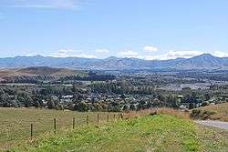 Waiau seen from the Leader Road. The Waiau River is in the background | |
 Waiau | |
| Coordinates: 42°39′16″S 173°02′33″E | |
| Country | New Zealand |
| Region | Canterbury |
| Territorial authority | Hurunui District |
| Population (2013) | |
| • Total | 261 |
| Time zone | UTC+12 (New Zealand Standard Time) |
| • Summer (DST) | UTC+13 (New Zealand Daylight Time) |
| Postcode | 7332 |
Waiau is the largest town on State Highway 70, also known as the Inland Kaikoura Route. From 1919 until 1978, Waiau was the terminus of the Waiau Branch, a branch line railway that ran to the town from a junction with the Main North Line in Waipara. There were proposals to extend this line beyond Waiau as part of the Main North Line and some 3 kilometres (1.9 mi) of formation was made for a route to Kaikoura, but construction ground to a halt and a coastal route via Parnassus and Hundalee was chosen for the Main North Line instead.
Waiau shares its name with several much smaller settlements and farming communities within New Zealand. The name is Maori, and means flowing water.[1]
Demographics
Waiau had a population of 261 at the 2013 New Zealand census, an increase of 9 people since the 2006 census. There were 135 males and 129 females. Figures have been rounded and do not add up to totals.[2] 88.2% were European/Pākehā, 21.2% were Māori, 0.0% were Pacific peoples and 0.0% were Asian.[3]
Education
Waiau School is a co-educational state primary school for Year 1 to 6 students,[4][5] with a roll of 33 as of March 2020.[6]
References
- "1000 Māori place names". New Zealand Ministry for Culture and Heritage. 6 August 2019.
- 2013 Census QuickStats about a place : Waiau
- 2013 Census QuickStats about a place (Cultural diversity) : Waiau
- "Waiau School Official School Website". waiau.ultranet.school.nz.
- "Waiau School Ministry of Education School Profile". educationcounts.govt.nz. Ministry of Education.
- "Waiau School Education Review Office Report". ero.govt.nz. Education Review Office.
External links
![]()