Vohipeno
Vohipeno is a town and commune in Madagascar. It belongs to the district of Vohipeno, which is a part of Vatovavy-Fitovinany Region. The population of the commune was estimated to be approximately 18,000 in 2001 commune census.[2]
Vohipeno | |
|---|---|
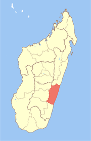
 Vohipeno Location in Madagascar | |
| Coordinates: 22°21′S 47°50′E | |
| Country | |
| Region | Vatovavy-Fitovinany |
| District | Vohipeno |
| Elevation | 6 m (20 ft) |
| Population (2001)[2] | |
| • Total | 18,000 |
| Time zone | UTC3 (EAT) |
In addition to primary schooling the town offers secondary education at both junior and senior levels. The town provides access to hospital services to its citizens. The majority 98% of the population of the commune are farmers. The most important crops are rice and coffee, while other important agricultural products are lychee and cassava. 1.6 percent of the population is employed in service industries, and 0.5 percent in fishing.[2]
Geography
Vohipeno is situated at 42 km from Manakara on the national road to Farafangana (RN 12). It is alongside the Matitanana River, also known as Matitana river.
References and notes
- Estimated based on DEM data from Shuttle Radar Topography Mission
- "ILO census data". Cornell University. 2002. Retrieved 2008-05-03.