Vlasina (river)
The Vlasina (Serbian Cyrillic: Власина), is a river in southeastern Serbia, a 70 km-long[1] outflow of the Vlasina Lake and a right tributary to the Južna Morava, which also gives its name to the surrounding Vlasina region.
| Vlasina (Власина) | |
|---|---|
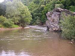 River Vlasina, location: Pukli kamen | |
| Location | |
| Country | Serbia |
| Physical characteristics | |
| Source | |
| • location | Vlasina Lake, southeastern Serbia |
| • elevation | 1,213 m (3,980 ft) |
| Mouth | |
• location | Južna Morava, east of Leskovac, Serbia |
• coordinates | 42°59′54″N 22°01′44″E |
| Length | 70 km (43 mi)[1] |
| Basin size | 991 km2 (383 sq mi)[2] |
| Basin features | |
| Progression | South Morava→ Great Morava→ Danube→ Black Sea |
River
The Vlasina flows out from the Vlasina Lake at an altitude of 1,213 m. Lake used to be a large, muddy peat bog, but in 1947-51 the Vlasina was dammed by the long, earth dam and the bog was turned into an artificial lake. The river flows to the north, between the mountains of Čemernik on the west, and Gramada on the east. It flows through Crna Trava, regional and municipal center, and the villages of Brod, Krstićevo and Jabukovik, where it reaches the Lužnica mountain and receives the Gradska reka from the right.
The river bends to the west, along the southern slopes of Lužnica, and receives from the right the Tegošnica (at Donje Gare village) and the Lužnica (at Svođe). As the Vlasina continues on the southernmost slopes of the Suva Planina and Babička Gora mountains, it reaches the town of Vlasotince and western parts of the low Leskovac field, part of the composite valley of the Južna Morava. After the villages of Batulovce and Stajkovce, the Vlasina empties into the Južna Morava, east of the Leskovac's eastern suburb of Mrštane.
The Vlasina drains an area of 991 km²,[2] belongs to the Black Sea drainage basin and it is not navigable.
On 26 June 1988, after a period of heavy rains, Vlasina was a site of catastrophic torrent floods. The area affected by the catastrophe covered more than 1000 km², and caused a damage of around US$1 billion, despite the river flow being supposedly regulated. Subsequent analysis showed a number of flaws in the design of the protected catchment.
References
| Wikimedia Commons has media related to Vlasina. |
- Statistical Yearbook of the Republic of Serbia 2017 (PDF) (in Serbian and English). Belgrade: Statistical Office of the Republic of Serbia. October 2017. p. 16. ISSN 0354-4206. Retrieved 30 May 2018.
- Velika Morava River Basin, ICPDR, November 2009, p. 2
- Mala Prosvetina Enciklopedija, Third edition (1985); Prosveta; ISBN 86-07-00001-2
- Jovan Đ. Marković (1990): Enciklopedijski geografski leksikon Jugoslavije; Svjetlost-Sarajevo; ISBN 86-01-02651-6
- Gavrilovic, Zoran; Matovic, Zivorad (January 1991). Armanini, Aronne; Silvio, Giampaolo (eds.). "Review of disastrous torrent flood on the vlasina river on June 26, 1988". Lecture Notes in Earth Sciences, Berlin Springer Verlag. 37: 235–250. Bibcode:1991LNES...37..235G. doi:10.1007/BFb0011177.