Virginia State Route 119
State Route 119 (SR 119) is a primary state highway in the U.S. state of Virginia. Known as Calvary Road, the state highway runs 3.08 miles (4.96 km) from the North Carolina state line, where the highway continues as North Carolina Highway 119 (NC 119), north to U.S. Route 58 and US 360 at Delila.
| ||||
|---|---|---|---|---|
| Calvary Road | ||||
 | ||||
| Route information | ||||
| Maintained by VDOT | ||||
| Length | 3.08 mi[1] (4.96 km) | |||
| Existed | 1964–present | |||
| Major junctions | ||||
| South end | ||||
| North end | ||||
| Location | ||||
| Counties | Halifax | |||
| Highway system | ||||
| ||||

Route description
_at_U.S._Route_58_and_U.S._Route_360_(Philpott_Road)_in_Delila%2C_Halifax_County%2C_Virginia.jpg)
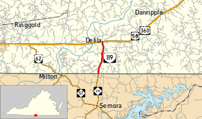
SR 119 begins at the North Carolina state line in southwestern Halifax County. The highway continues south as NC 119 through the northeastern corner of Caswell County to Semora. SR 119 heads north as a two-lane road through a mix of forest and farmland. The state highway passes Calvary Cemetery about halfway between the state line and the highway's northern terminus at US 58 and US 360 (Philpott Road) at the hamlet of Delila between Danville and South Boston.[1][2]
Major intersections
The entire route is in Halifax County.
| Location | mi[1] | km | Destinations | Notes | |
|---|---|---|---|---|---|
| | 0.00 | 0.00 | North Carolina state line | ||
| Delila | 3.08 | 4.96 | |||
| 1.000 mi = 1.609 km; 1.000 km = 0.621 mi | |||||
References
- "2010 Traffic Data". Virginia Department of Transportation. 2010. Retrieved 2011-10-27.
- Halifax County (PDF)
- Google (2011-10-27). "Virginia State Route 119" (Map). Google Maps. Google. Retrieved 2011-10-27.
External links
| Wikimedia Commons has media related to Virginia State Route 119. |