North Carolina Highway 119
North Carolina Highway 119 (NC 119) is a primary state highway in the U.S. state of North Carolina.
| ||||
|---|---|---|---|---|
 | ||||
| Route information | ||||
| Maintained by NCDOT | ||||
| Length | 42.9 mi[1] (69.0 km) | |||
| Existed | ca. 1940–present | |||
| Major junctions | ||||
| South end | ||||
| North end | ||||
| Location | ||||
| Counties | Alamance, Caswell | |||
| Highway system | ||||
| ||||

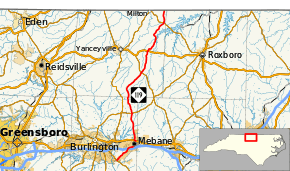
Route description
It runs from NC 54 in Swepsonville north via Mebane, Hightowers, and Semora to the Virginia state line, where it continues as State Route 119.
History
Established in 1940, NC 119 was a renumbering of NC 103 between NC 54 and NC 49, in Alamance County. In 1954, NC 119 was extended north, on new primary routing, to the Virginia border.[2][3] In 1964, Virginia reciprocated by establishing SR 119 from the state line north to US 58/US 360.
Future
A project that started since 1990 is in the works to relocate NC 119 west of Mebane, creating a new 4 to 6-lane divided highway from I-40/I-85 to Mrs. White Lane (SR 1918). The project will be broken into two parts, with a combined estimate of $101.9 million; property acquisition is expected after 2014.[4]
Junction list
| County | Location | mi | km | Destinations | Notes |
|---|---|---|---|---|---|
| Alamance | Swepsonville | 0.0 | 0.0 | Southern terminus | |
| Mebane | 4.0 | 6.4 | Diamond interchange; exit 153 on I-85 | ||
| 6.9 | 11.1 | South end of concurrency with US 70 | |||
| 7.2 | 11.6 | North end of concurrency with US 70 | |||
| Pleasant Grove | 13.9 | 22.4 | |||
| Caswell | Hightowers | 25.5 | 41.0 | ||
| Leasburg | 31.1 | 50.1 | |||
| Semora | 39.8 | 64.1 | |||
| Milton | 42.9 | 69.0 | Northern terminus; Virginia state line | ||
1.000 mi = 1.609 km; 1.000 km = 0.621 mi
| |||||
See also
- North Carolina Bicycle Route 4-Concurrent with NC 119 from Stephentown Road to Osmond Road near Hyco Lake
References
- Google (2011-11-24). "North Carolina Highway 119" (Map). Google Maps. Google. Retrieved 2011-11-24.
- North Carolina Primary Highway System (Map). Cartography by NCSHC. Raleigh: North Carolina State Highway and Public Works Commission. 1953. Retrieved December 13, 2018.
- North Carolina Official Highway Map (Map). Cartography by NCSHC. Raleigh: North Carolina State Highway and Public Works Commission. 1954. Retrieved December 13, 2018.
- "NCDOT: NC 119 Relocation Project". Retrieved 2011-11-24.