Virginia Barrier Islands
The Virginia Barrier Islands are a continuous chain of long, narrow, low-lying, sand and scrub barrier islands separated from one another by narrow inlets and from the mainland by a series of shallow marshy tidal bays along the entire coast of the Virginia end of the Delmarva Peninsula.[1][2][3] The sole remaining habitation on these islands, the town Broadwater, Virginia, was evacuated in 1936 following a hurricane.[4] Because they are uninhabited they form an important ecological region, and several make up the Virginia Coast Reserve.[5]
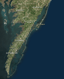
The Virginia Barrier Islands terminate to the south at the mouth of the Chesapeake Bay and are preceded to the north by Fenwick Island, a barrier spit, not a true island, spanning the Maryland and Delaware border (Transpeninsular Line). They are, in order from north to south:
- Assateague Island - the first true barrier island from the north and the longest of the barrier islands. It is divided between Maryland and Virginia and is home to a feral horse population, the Chincoteague Pony.
- Chincoteague Island- was a barrier island until the mid-19th Century, when Assateague migrated so far south that it shielded Chincoteague from the ocean.
- Wallops Island - the base of NASA's Wallops Flight Facility.
- Assawoman Island - part of Chincoteague National Wildlife Refuge
- Metompkin Island -split between the Nature Conservancy and Chincoteague National Wildlife Refuge
- Cedar Island - A former US Coast Guard station still stands on the island and is seasonally inhabited by its private owners. The last private house slipped into the sea in 2014[6]
- Parramore Island - owned by the Nature Conservancy.
- Hog Island - location of the former town of Broadwater, Virginia. Origin of the Hog Island Sheep.
- Cobb Island - once also inhabited with a resort hotel, church, and small town, until the 1896 hurricane
- Wreck Island
- Shipshoal Island
- Myrtle Island
- Smith Island - once held by the Custis family of Virginia. Martha Custis Washington owned the island, as did her great-granddaughter, whose husband Robert E. Lee gave an account of the island after inspecting it in 1832 while stationed at nearby Fort Monroe.[7] It hosts the Cape Charles Lighthouse, the tallest lighthouse in Virginia and the second tallest in the United States.[8]. Smith Island is now owned by the Nature Conservancy.
- Fisherman Island- is the southernmost of the Virginia barrier islands. Located at the entrance to the Chesapeake Bay, the island is subject to great changes in its landscape due waves and runoff. It first formed approximately 200 to 250 years ago. Fisherman Island National Wildlife Refuge is located within the United States Fish and Wildlife Service's Eastern Shore of Virginia National Wildlife Refuge, and is bisected by U.S. Highway 13 and the Chesapeake Bay Bridge Tunnel. The island is the habitat of migratory waterfowl, shorebirds, and nesting waterbirds.
See also
- Barrier Islands
- Outer Banks
- Delmarva
Notes
- Barrier Islands Center on Virginia's Eastern Shore
- Charles McGuigan (July–August 2012). "Virginia's Barrier Islands". North of the James Magazine. Retrieved 2014-07-27.
- Brooks M. Barnes, Barry R. Truitt, and William W. Warner, eds., Seashore Chronicles: Three Centuries of the Virginia Barrier Islands, University Press of Virginia, 1997. ISBN 0-8139-1879-0
- Fariss Samarrai (July 2000). "Shifting sands". University of Virginia, Arts & Sciences Magazine. Retrieved 2014-07-27.
- Connie Bond. "Shifting sands". Chesapeake Bay Magazine. Retrieved 2014-07-27.
- http://www.bayjournal.com/article/last_cedar_island_house_slips_into_sea
- Barry Truitt, "Robert E. Lee: An Account of His Visit to Smith Island" in Brooks M. Barnes, Barry R. Truitt, and William W. Warner, eds., Seashore Chronicles: Three Centuries of the Virginia Barrier Islands, University Press of Virginia,1997.
- Rowlett, Russ. "Lighthouses of the United States: Virginia". The Lighthouse Directory. University of North Carolina at Chapel Hill.
References
- Brooks M. Barnes, Barry R. Truitt, and William W. Warner, eds., Seashore Chronicles: Three Centuries of the Virginia Barrier Islands, University Press of Virginia, 1997. ISBN 0-8139-1879-0
- colespointmarina.com/shark-tooth-island/
| Preceded by Wallops Island |
Beaches of Delmarva | Succeeded by Southernmost point |