Višnjica, Serbia
Višnjica (Serbian Cyrillic: Вишњица; pronounced [ʋîʃɲitsa ]) is an urban neighborhood of Belgrade, the capital of Serbia. It is located in Belgrade's municipality of Palilula.
Višnjica Вишњица | |
|---|---|
 Picture of Višnjica, overlooking the Danube. | |
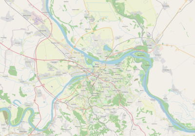 Višnjica Location within Belgrade | |
| Coordinates: 44°49′51″N 20°32′52″E | |
| Country | |
| Region | Belgrade |
| Municipality | Palilula |
| Area | |
| • Total | 8.17 km2 (3.15 sq mi) |
| Time zone | UTC+1 (CET) |
| • Summer (DST) | UTC+2 (CEST) |
| Area code | +381(0)11 |
| Car plates | BG |
Location

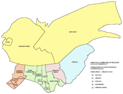
Višnjica is located on the right bank of the Danube, stretching for almost 5 kilometers, from the Danube's arm of Rukavac and Ada Huja peninsula (including the Višnjica marina) almost to the weekend-settlement of Bela Stena. The original village of Višnjica developed between the northern part of the Višnjica field and the Danube, but today makes one continuous built-up area with the rest of the city, through the bordering neighborhoods of Ada Huja, Rospi Ćuprija and Karaburma on the west and its own modern extension of Višnjička Banja, mainly on the south. The main street connecting it to downtown is Višnjička.
History and population
Until the 1970s, Višnjica was a separate village and a suburban settlement of Belgrade. With the massive administrative reorganization of the Belgrade City limits after the 1971 population census, entire eastern and southern string of more or less urbanized suburbs (Višnjica, Mirijevo, Mali Mokri Lug, Veliki Mokri Lug, Selo Rakovica, Jajinci, Kijevo, Kneževac, Resnik, Železnik, Žarkovo) were administratively annexed to the Belgrade City proper (uža teritorija grada), turning from the separate settlements into the "local communities" (mesna zajednica). Population of Višnjica, according to the official censuses of population:
Until 1971, data are for the separate settlement of Višnjica, 1981 is for the local community of Višnjica within Belgrade, and 2002 and 2011 is for the combined local communities of Višnjica and Višnjička Banja.
The name of the neighborhood, Višnjica, is Serbian for the sour cherry orchard. The entire area, stretching from Karaburma and Viline Vode on the east, was known for its thermal springs and healing mud which gave name to the new neighborhood of Višnjička Banja (Serbian for "Višnjica spa").
Characteristics
As a former village, Višnjica is a residential area without industrial or commercial facilities. The distance from the downtown (7-8 kilometers) and a bad public transportation are the main communal problems in the neighborhood.
Overlooking the easternmost, wooded section of Ada Huja and the Danube itself, Višnjica, just as Viline Vode closer to downtown, was projected as an elite neighborhood in the project of "Belgrade's descend to the river banks". However, the idea of a rich settlement with villas and mansions was dropped with the economic crisis in former Yugoslavia in the late 1980s and succession of Yugoslav wars in 1990s. Population of the local community of Višnjica, after Višnjička Banja administratively split in the 1990s was 3,611 in 2002 and 4,527 in 2011.
A new island in front of Višnjica, called Paradajz, began to form around 1986, due to the alluvial silt brought by the Danube. Until 2011 it grew to an area of 2 ha (4.9 acres).[3] As the island expanded, it formed a canal in front of Višnjica. Canal is named "Karlica" and is today considered the better access path to Ada Huja's bay of Rukavac where the Višnjica Marina is located.[4] The island was originally round but by 2017 it got elongated and grew into the almost perfectly symmetrical eye shape.
South of Višnjica is the partially forested Milićevo Hill. The forest covers 43.8 ha (108 acres).[5]
Višnjička Banja
Višnjička Banja (Serbian Cyrillic: Вишњичка Бања, pronounced [ʋîʃɲitʃkaː bâɲa]) is located in the northern section of the Višnjica field, between the neighborhoods of Rospi Ćuprija to the west, Lešće to the southeast and Višnjica to the north.
The modern neighborhood was built as an urban connection of the former village of Višnjica to the rest of Belgrade. It was projected by Ljiljana and Dragoljub Bakić.[6] It was named after many thermal springs of the sulfur water and healing mud near Višnjica (Višnjička Banja is Serbian for Višnjica spa). The springs, for the most part, have been artificially shut down and conducted underground into the city's sewage system. The springs are further compromised by the contaminated mud in the Ada Huja's Rukavac.[7]
The area is residential, without specific borders with Višnjica itself. Southern section of the neighborhood has many brickworks, but as boundaries of the neighborhoods in Belgrade are mostly arbitrary, some place this industrialized section in Rospi Ćuprija. Local community had the population of 8,497 in 2002 and 7,544 in 2011.
Sub-neighborhood of Kaskade was built in 1978 between the streets of Romena Rolana and Višnjička. It was constructed on the steep slope prone to the mass wasting so the buildings were built on the piles. In an effort to embed the piles into the rocky ground below, the piles had to be 40 meters long.[8]
Višnjičko Polje
The regulatory plan for the construction of the neighborhood of Višnjičko Polje was given green light on 15 May 2007,[9][10][11] but never materialized. According to the plan, the future city within the city was supposed to cover an area of 81 hectares with 7,500 apartments with a total area of 900.000 square meters. After Bežanijska Kosa in 1987, this was to be the first grand-scale planned neighborhood of Belgrade.
The neighborhood should be located in the Višnjica field (thus the name). It was to border the neighborhoods of Višnjička Banja on the north, Lešće on the east, and Ćalije and Rospi Ćuprija on the west. Future boundary of the neighborhood would also be the projected internal Belgrade's beltway.
As the inclination of the terrain is 7 to 10%, the neighborhood was to be built in the amphitheater style. Unlike other planned neighborhoods in Belgrade, Višnjičko Polje wasn't planned to ave sky-scrapers: 50% individual houses while only 20% made of four-storey buildings. 600 apartments were planned for the Romani families which currently live in the area in an informal settlement.
The projected neighborhood had two projected centers: Center 1, around the present brickworks Rekord, designed for the culture and commerce, and Centar 2, around the present brickworks Kozara, designed for the sports and recreation. The neighborhood was supposed to have a nursery, kindergarten, elementary school, sports fields, etc. Being a massive project, it was expected that 10 to 12 projecting teams will be building it. The city government decided that the neighborhood will be not built partially, but as a whole.
Vrtača, a water hole artificially created as a result of clay digging for the neighboring brickworks, should remain a reservation of nature to protect the present plant and animal life in it. It is currently inhabited by the egrets, mallards. shelducks, grass snakes, etc.
References
- Popis stanovništva po mesnim zajednicama, Saopštenje 40/2002, page 4. Zavod za informatiku i statistiku grada Beograda. 26 July 2002.
- Stanovništvo po opštinama i mesnim zajednicama, Popis 2011. Grad Beograd – Sektor statistike (xls file). 23 April 2015.
- Dimitrije Bukvić (4 October 2011). "Oaza na ostrvu samoniklog paradajza" (in Serbian). Politika.
- "Ono što znamo i ne znamo o Dunavu" (in Serbian). 20 August 2009.
- Anica Teofilović, Vesna Isajlović, Milica Grozdanić (2010). Пројекат "Зелена регулатива Београда" - IV фаза: План генералне регулације система зелених површина Београда (концепт плана). Urbanistički zavod Beograda.CS1 maint: multiple names: authors list (link)
- Radoslav Ćebić (31 May 2018). "Tiranija Beograda na void" [Tyranny of the Belgrade Waterfront]. Vreme, No. 1430 (in Serbian).
- Dimitrije Bukvić (4 October 2011). "Oaza na ostrvu samoniklog paradajza" (in Serbian). Politika.
- M.Luković (17 March 2009). "Gradnja na klizišzu u Višnjičkoj banji i dalje traje" (in Serbian). Politika.
- Politika, 16 May 2007, page 25 & 5 June 2007, page 23
- Beoinfo
- Glas Javnosti
Sources
- Mala Prosvetina Enciklopedija, Third edition (1986), Vol.I; Prosveta; ISBN 86-07-00001-2
- Jovan Đ. Marković (1990): Enciklopedijski geografski leksikon Jugoslavije; Svjetlost-Sarajevo; ISBN 86-01-02651-6
- Beograd - plan grada; M@gic M@p, 2006; ISBN 86-83501-53-1
- Beograd - plan i vodič; Geokarta, 1999; ISBN 86-459-0006-8
External links
| Wikimedia Commons has media related to Višnjica. |