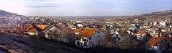
Mirijevo
Mirijevo ((Serbian: Миријево), pronounced [mǐrijɛʋɔ]) is an urban neighborhood of Belgrade, the capital of Serbia. It is located in Belgrade's municipality of Zvezdara. One of the largest single neighborhoods in Europe, consists of several sub-neighborhoods (Staro & Novo Mirijevo, Mirijevo II-IV, etc.)
Mirijevo Миријево | |
|---|---|
 Mirijevo | |
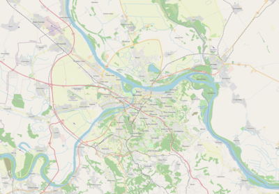 Mirijevo Location within Belgrade | |
| Coordinates: 44.7894°N 20.5302°E | |
| Country | |
| Region | |
| Municipality | Zvezdara |
| Population (2011) | |
| • Total | 41,407 |
| Time zone | UTC+1 (CET) |
| • Summer (DST) | UTC+2 (CEST) |
| Area code | +381(0)11 |
| Car plates | BG |
Location and geography
Mirijevo is located 11 kilometers east of downtown Belgrade, on the eastern outskirts of Belgrade's urban zone. It extends into the neighborhoods of Ćalije on the north, Zvezdara on the west and Mali Mokri Lug (Zeleno Brdo) on the south. The neighborhood developed in the valley of Mirijevski potok (creek which is a right tributary to the Danube, at the neighborhood of Rospi Ćuprija), between the Zvezdara hill in the west (253 meters), Orlovica hill (274 meters, read as Orlovitsa; on some city maps given as Orlovača) in the north-east and Stojčino hill (274 meters) in the south, so the neighborhood today mostly develops in the south-east, the only remaining unurbanized part of the valley.
The territory of Mirijevo was a mass wasting area. During the rapid construction of the neighborhood from the 1970s, since majority of the buildings were highrise, the terrain was systematically improved. As a result, the movement of the land is today completely halted and Mirijevo is considered as the most successful project of fixing the mass wasting problem in Belgrade.[1]
History and population
| Historical population | ||
|---|---|---|
| Year | Pop. | ±% |
| 1921 | 1,410 | — |
| 1953 | 2,067 | +46.6% |
| 1961 | 3,607 | +74.5% |
| 1971 | 7,936 | +120.0% |
| 1981 | 16,141 | +103.4% |
| 1991 | 35,703 | +121.2% |
| 2002 | 36,590 | +2.5% |
| 2011 | 41,407 | +13.2% |
| Source: [2][3][4][5] | ||
In the 19th and early 20th century, the area of modern Bulbulder neighborhood in Zvezdara consisted of yards and gardens. Bulgarian settlers were cultivating vegetables, which was then directly sold on the wooden benches in front of the gardens. The settlement changed after the city cemetery was transferred from Tašmajdan to the northern section of the Bulbulder, as the Belgrade New Cemetery, in the 1886-1927 period. The creek of Bulbuderski potok was channeled and the construction of the houses began while the gardeners were transferred to Mirijevo.[6]
Mirijevo used to be a separate village, outside Belgrade's urban zone, but as Belgrade developed, by the early 1970s Mirijevo became part of the city's urban area and lost separate status after 1971, becoming local community (mesna zajednica, sub-municipal administrative unit) within Belgrade city proper (uža teritorija grada). Massive population growth ensued. In 2011 population of the settlement was 41,407.
Municipality movement
Movement which gained momentum during the ongoing protest from the local population against construction of the power transformer in the center of the neighborhood from the late 1990s. However, the idea is on hiatus at the moment.[7]
Sub-neighborhoods
Staro Mirijevo
Staro Mirijevo (Old Mirijevo) is the oldest part of the neighborhood, area of the former village of Mirijevo and it constitutes a separate local community. It occupies the northern section of the entire neighborhood, on the both sides of Mirijevski Potok, bordering Ćalije on the north, Zvezdara on the west, Orlovsko Naselje on the north-east, Mirijevo II on the south and Mirijevo III on the south-east. Area is mostly made from individual residential houses, with a population of 7,604 by the 2002 census (including Orlovsko Naselje) and 13,318 in 2011. Central streets are Jovanke Radaković and Vitezova Karađorđeve zvezde. Orthodox church of the Saint Prophet Elias is in the center of the neighborhood.
Novo Mirijevo
Novo Mirijevo (New Mirijevo) is a joint name for the local community with a population of 28,986 by the 2002 census and 28,089 in 2011. It consists of Mirijevo II, III and IV.
Mirijevo II
Central part of the neighborhood, characterized by the large residential buildings. It borders Staro Mirijevo on the north, Mirijevo III on the east and extends into Mali Mokri Lug on the south-west. Central street, going through the center of the neighborhood is Mirijevski venac while the southern border is marked by the parallel Matice srpske street. In April 2008 grassy area between the Mirijevski venac and Radivoja Markovića streets was projected as the future and first real park in the neighborhood.[8] Park will consist of the linden trees and the existing playgrounds and bocce court will be renovated and become part of the park.
Mirijevo III
Eastern part of the neighborhood, entirely residential. Bounded by the streets of Matice srpske on the west and Koste Nađa on the east, it borders Mirijevo II on the west and Mirijevo IV on the south-east. A new Health Center, under construction since the 1990s was finally finished in 2009, while a new kindergarten was also completed in 2008.
Mirijevo IV
The latest, south-eastern extension of the neighborhood. From Koste Nadja Street and along Samuel Beckett and Mikhail Bulgakov Streets, this is the largest of the Mirijevo neighborhoods. One of the largest schools in Belgrade and Serbia, Pavle Savic Elementary School is also located there. The newest parts of the neighborhood extend along the 1,1 kilometer long road connecting Mirijevo to the Smederevski put, a road connecting Belgrade and Smederevo via Belgrade's suburb of Grocka. The road was opened in 2007 and shortened the trip from suburbs in Grocka direction (like Kaluđerica) for 11 kilometers. For over a 20 years a beltway circumventing central part of Mirijevo is planned and the construction should began in 2008. It will bypass the neighborhood from Mirijevo IV, through the unurbanized eastern side to the beginning of the Mirijevo boulevard in the southern part of the neighborhood of Ćalije, north of Mirijevo itself.[9]
Orlovsko Naselje
Orlovsko Naselje (Serbian Cyrillic: Орловско насеље) is the north-eastern extension of Mirijevo. It is mostly an informal settlement of the Romani people. The main street in the settlement is Orlovska, meaning "eagle street" (thus the neighborhood is called "eagle settlement") as it leads into the foothills of the neighboring Orlovača hill ("eagle hill").
The settlement was established in 1815.[10] In 1968-1969, the inhabitants were partially resettled across the other parts of the city in the newly built apartments.[11] In the early 2000s, various alleys of the Orlovska street were named after people who were connected to Romani people, either by their origin or through their work: Django Reinhardt, Yul Brynner, Rabindranath Tagore, Jovan Janićijević Burduš, etc. Population of the settlement is estimated to 900[12]-1,000.[10]
Šoferski Raj
Small settlement developed in the mid 2000s, along the Ljubiše Miodragovića street, as the southernmost extension of Mirijevo. As majority of the original inhabitants were truck or bus drivers, the settlement is colloquially named Šoferski Raj (Chauffeur’s Paradise). It developed without building permits and lacks the basic communal infrastructure like street lights, public transportation, grocery shops, proper power grid, etc.[13]
Transportation
Mirijevo Boulevard
Mirijevo was badly connected to the rest of the city, mostly through the narrow streets in Zvezdara (Milana Rakića, Mite Ružića) bringing heavy traffic to the Bulevar Kralja Aleksandra. In the late 1990s, the idea of constructing the Mirijevo Boulevard (Serbian: Миријевски булевар, romanized: Mirijevski bulevar), in the north-to-south direction was proposed, which would connect Mirijevo to the Višnjička street on the north, thus connecting it to the Rospi Ćuprija, Karaburma, Bogoslovija and further with the downtown. Due to the property ownership problems, the construction dragged for years. Final phase began on 7 February 2011 and was finished in November. It included the construction of the final 1 km (0.62 mi) of the boulevard, intersections with the Mirijevo's cross streets, sidewalks, city lights and the 1.25 km (0.78 mi) long underground concrete collector which conducted the stream of Mirijevski potok underground.[14][15]
References
- Nikola Belić (8 November 2011), "Klizišta nisu samo hir prirode", Politika (in Serbian)
- Popis stanovništva 1961, Stanovništvo prema nacionalnom sastavu (pdf). Savezni zavod za statistiku, Beograd.
- Popis stanovništva 1971, Stanovništvo prema nacionalnom sastavu (pdf). Savezni zavod za statistiku, Beograd.
- Popis stanovništva po mesnim zajednicama, Saopštenje 40/2002, page 4. Zavod za informatiku i statistiku grada Beograda. 26 July 2002.
- Stanovništvo po opštinama i mesnim zajednicama, Popis 2011. Grad Beograd – Sektor statistike (xls file). 23 April 2015.
- Svetlana Brnović Mitić (15–16 February 2019). "Крај Београда у којем су успевали славуји и фудбалери" [Neighborhood of Belgrade which thrived in nightingales and footballers]. Politika (in Serbian).CS1 maint: date format (link)
- Politika, October 20, 2007, p.27
- Politika, April 18, 2008, p.28
- Politika, January 18, 2007, p.26
- Dragana Jokić Stamenković (27 December 2011). "Najstarije romsko naselje dobija stabilnu struju" (in Serbian). Politika.
- B.Trbojević (12 February 1969). "Нестаће Маринкова бара и Прокоп" [Marinkova Bara and Prokop will disappear]. Politika (reprint on 12 February 2019, page 20) (in Serbian).
- Politika, May 6, 2008, p.26
- S.Despotović, "Šoferski raj – naselje u mraku", Politika (in Serbian)
- Dejan Spalović (15 October 2011), "Hiljadu metara nove saobraćajne arterije", Politika (in Serbian)
- Dragana Jokić Stamenković, Dejan Spalović (27 October 2011), "Autobusom 25-P kroz Mirijevski bulevar", Politika (in Serbian)