Vermilion Coast Tracks
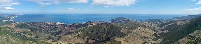
The Vermilion Coast Tracks follow the mediterranean coastline of the Pyrenees from Argelès-sur-Mer to Cerbère the border town with Spain. Passing through several types of forest, and vineyards, this tracks often provides excellent views over the sea. It is classified as one of Pyrénées-Orientales's Great Hikes, and is located in the Massane Forest Natural Reserve.[1]
Hiking on the Vermilion Coast
The trailheads are at Cerbère, and Argelès, on the southern and northern edges of the Vermilion coast respectively. Most people take 1 to 2 days to complete the trails.
The trails passes through several areas of private land, and touches the edge of the Cerbère-Banyuls Natural Marine Reserve where a special scuba diving underwater trail is open to the public in the summer.[2]
Cerbère to Banyuls by the Torre de Querroig
12km [7.5 miles], approximately 5 hours. A technical route for experienced walkers. Unsuitable in high winds. Starting in the village of Puig del Mas, follow the path that Jewish writer, Walter Benjamin and friends took to escape Nazi persecution in occupied France. Climb to The 13th century Torre de Querroig (672m).[3]
Port Vendres to Banyuls by the Littoral Trail
12km [7.5 miles], approximately 4 hours. This trail can be done back and forth, in any direction. A well maintained path but the cliffs can be dangerous if it is windy, and the wind can be extremely strong at Cap Bear. The walk takes in the historic site of Paullilles, the 18th century museum, Redoute Bear and the active military installation, Fort Bear.[4]
The Madeloc Tower & Military Installations
21.5km [13.5 miles], approximately 6 hours. Intermediate level with some technical areas. Begin from Place de l'Obélisque, in Port Vendres, walking via Cosprons, Fortress Galline, Batterie 500, Tour de Madeloc (656m), Batterie Taillefer, Fort Dugommier & Fort St Elme before dropping back to Port Vendres.[5]
The Ultrera Castle
7km [3 miles], approximately 4 hours. Some steep climbs/descents and rocky ledges. Starting in La Vall (between Sorède and Argelès-sur-Mer) the walk climbs up to the Château d'Ultrera, passing the 10th century Chapelle de la Pavé.[6]
Transport
Location
See also
References
| Wikimedia Commons has media related to Vermilion Coast Tracks. |
- "Forêt de la Massane - RESERVES NATURELLES DE FRANCE". Retrieved 23 April 2017.
- "Archived copy". Archived from the original on July 6, 2009. Retrieved June 23, 2009.CS1 maint: archived copy as title (link)
- "Walk Tour de Querriog". www.anglophone-direct.com. 10 November 2016.
- "Walk Cap Bear". www.anglophone-direct.com. 23 January 2018.
- "Tour de Madeloc". www.anglophone-direct.com. 19 October 2016.
- "Walk Château d'Ultrera". www.anglophone-direct.com. 13 December 2013.