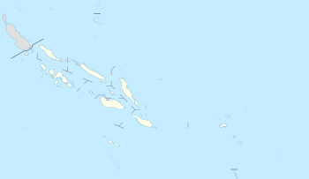
Vanikoro
Vanikoro (sometimes wrongly named Vanikolo) is an island in the Santa Cruz group, located 118 kilometres (73 miles) to the Southeast of the main Santa Cruz group. It is part of the Temotu Province of the Solomon Islands.
 Vanikoro from space. Courtesy NASA | |
 | |
| Geography | |
|---|---|
| Archipelago | Santa Cruz Islands |
| Area | 173 km2 (67 sq mi) |
| Administration | |
Solomon Islands | |
| Province | Temotu |
| Demographics | |
| Population | 1300 (2009) |
| Ethnic groups | Melanesian, Polynesian |
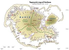
The name Vanikoro is always used as though it referred to a single island, due to both its geophysical and cultural unity. However, technically it is a group of several nearby islands surrounded by a single belt of coral reef. Only the two major islands are inhabited: the bigger one Banie, and the smaller one Teanu (or Tevai). Other, uninhabited islets in the Vanikoro group include Manieve, Nomianu and Nanunga. The total area of the Vanikoro group is 173 square kilometres (66.8 square miles).
Population and languages
The 1300 inhabitants of Vanikoro[2] consist of two different populations, who tend to live separately. The Melanesian majority, about 800 people, are the descendants of the original population of Vanikoro. A minority of about 500 individuals are of Polynesian descent; for the last few centuries they have established settlements on the southern coast of Banie, even though they still preserve close links with Tikopia, an island lying 200 kilometres (124 miles) eastwards, which they identify as their origin.
The three languages spoken by the Melanesian population of Vanikoro are all Oceanic, of the Temotu subgroup:[3]
The Tikopian settlers speak a Polynesian language, Tikopian or fakatikopia.
History
The first sighting of Vanikoro by Europeans was in September 1595, by the second Spanish expedition of Álvaro de Mendaña. It was sighted by Lorenzo Barreto, while in command of one of the smaller vessels on a voyage around the then Santa Cruz, which is today's Nendo Island.[4][5]
The French explorer Jean-François de La Pérouse was stranded on Vanikoro after both his vessels, La Boussole and the Astrolabe, struck the then unknown reefs of the island in 1788. It is reported[6] that some of the men were killed by the local inhabitants, while the surviving sailors built a smaller vessel and left the island, but were never seen again. Those that remained on the island died before search parties arrived in 1826. Jules Verne dedicates a chapter of his novel Twenty Thousand Leagues Under the Sea to this event.[7] Author Naomi Williams' novel Landfalls explores the Lapérouse expedition in depth.[8]
Notes
- Source: Maps of Vanikoro (languages, place names) by linguist A. François.
- "Report on 2009 Population & Housing Census". Solomon Islands Population & Housing Census 2009. Solomon Islands National Statistics Office. 2009.
- François, Alexandre (2009), "The languages of Vanikoro: Three lexicons and one grammar" (PDF), in Evans, Bethwyn (ed.), Discovering history through language: Papers in honour of Malcolm Ross, Pacific Linguistics 605, Canberra: Australian National University, pp. 103–126.
- Sharp, Andrew The discovery of the Pacific Islands Oxford, 1960, pp.52-55.
- Brand, Donald D. The Pacific Basin: A History of its Geographical Explorations The American Geographical Society, New York, 1967, p.136.
- See summary article in The Times, May 13, 2005.
- Verne, Jules (1992). Twenty Thousand Leagues Under the Sea. Hertfordshire: Wordsworth Classics. pp. 81–85.
- Naomi, Williams. "Landfalls". naomijwilliams.com. Farrar, Straus and Giroux. Retrieved 27 April 2017.
References
- Vanikoro Island (archived link)
- (in French) A linguist in Vanikoro.