Vallorcine
Vallorcine is a municipality in the Haute-Savoie department in the Auvergne-Rhône-Alpes region in south-eastern France.
Vallorcine | |
|---|---|
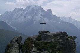 View of the cross of Loriaz on the heights of Vallorcine | |
Location of Vallorcine 
| |
 Vallorcine  Vallorcine | |
| Coordinates: 46°02′07″N 6°56′02″E | |
| Country | France |
| Region | Auvergne-Rhône-Alpes |
| Department | Haute-Savoie |
| Arrondissement | Bonneville |
| Canton | Le Mont-Blanc |
| Intercommunality | SIVOM Mont Blanc |
| Government | |
| • Mayor (2014-2020) | Jérémy Vallas |
| Area 1 | 44.57 km2 (17.21 sq mi) |
| Population (2017-01-01)[1] | 400 |
| • Density | 9.0/km2 (23/sq mi) |
| • Urban | 60,234 |
| Time zone | UTC+01:00 (CET) |
| • Summer (DST) | UTC+02:00 (CEST) |
| INSEE/Postal code | 74290 /74660 |
| Elevation | 1,120–3,098 m (3,675–10,164 ft) |
| Website | Vallorcine.com |
| 1 French Land Register data, which excludes lakes, ponds, glaciers > 1 km2 (0.386 sq mi or 247 acres) and river estuaries. | |
Description
Vallorcine is located in the Valley of the L'Eau Noire between the Col des Montets and the Swiss border.
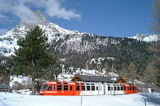
It is the terminus of the Saint-Gervais–Vallorcine railway on the route between St Gervais des Bains in France and Martigny in Switzerland, and is served by a railway station where passengers must change between French and Swiss trains. In the Swiss direction the line continues to Chatelard where it joins the Martigny–Châtelard Railway which is partially rack-operated.
There is a small museum at Barberine next to the Swiss border and there is a tourist information office and a post office near the railway station.
Le Buet
Within the community is the small settlement of Le Buet, which also has its own railway station, and is the location of the spectacular Cascade de Berard, which has a viewing gallery that enters the gorge of the main waterfall. Further up this valley is the Red Needles National Park, and the National Nature Reserve of Berard.
Skiing
The community was transformed in 2004 with the construction of a high-speed gondola lift which allowed access to the established Domaine de Balme and La Tour ski areas. This gave rise to the construction of a selection of restaurants and ski accommodation.[2]
The Émosson Dam
Although the Émosson Dam for hydroelectric power generation.is physically just over the Swiss border, water from the reservoir crosses the border to first power the 189 MW Vallorcine Power Station just over the border in Vallorcine. Water is then sent through a headrace tunnel to the 162 MW La Bâtiaz Power Station, 12 km (7 mi) to the east in Martigny, Switzerland. The drop between the dam and La Bâtiaz Power Station is 1,400 m (4,593 ft).[3]
Demography
| Year | 1962 | 1968 | 1975 | 1982 | 1990 | 1999 | 2006 | 2007 |
|---|---|---|---|---|---|---|---|---|
| Population | 271 | 314 | 283 | 303 | 329 | 390 | 413 | 416 |
| From the year 1962 on: No double counting—residents of multiple communes (e.g. students and military personnel) are counted only once. 1999: Provisional population (annual survey). | ||||||||
See also
- Communes of the Haute-Savoie department
- Barberine Dam
- Le Buet
References
- "Populations légales 2017". INSEE. Retrieved 6 January 2020.
- "Vallorcine Chamonix Mont-Blanc, Haute-Savoie, French Alps". Mountain Passions. Retrieved 30 June 2018.
- "Électricité Émosson SA" (in French). Electricity of Émosson. Retrieved 29 April 2013.
- INSEE
| Wikimedia Commons has media related to Vallorcine. |
| Authority control |
|
|---|