Farallon de Pajaros
Farallón de Pájaros (from Spanish Farallón de los pájaros, meaning "Birds' Rock"), also known as Urracas (from Spanish Urracas, meaning "Magpies"), is a small (2.3 km2) uninhabited volcanic island, the northernmost island in the Northern Mariana Islands chain.
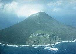 view of Farallón de Pájaros | |
 | |
| Geography | |
|---|---|
| Location | Pacific Ocean |
| Coordinates | 20°32′42″N 144°53′37″E |
| Archipelago | Mariana Islands |
| Area | 2.3 km2 (0.89 sq mi) |
| Length | 1.8 km (1.12 mi) |
| Width | 1.6 km (0.99 mi) |
| Highest elevation | 360 m (1,180 ft) |
| Highest point | Farallon de Pajaros |
| Administration | |
United States | |
| Commonwealth | Northern Mariana Islands |
| Demographics | |
| Population | - uninhabited - (2010) |
Geography
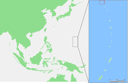
Farallón de Pájaros is the northernmost island of the Marianas chain. It is located 65 kilometers (40 mi) northwest of the Maug Islands and 591 km (367 mi) north of Saipan, the main island of the Northern Mariana Islands. Its northern neighbor is South Iwo Jima of the Ogasawara Islands of Japan, located 541 km (336 mi) away.
Farallón de Pájaros is nearly circular, with a length of 1.8 km (1.1 mi), a width of 1.6 km (0.99 mi) and has an area of 2.3 km2 (0.89 sq mi).[1] Farallón de Pájaros is the top of an active stratovolcano with a height of 360 meters (1,180 ft) above sea level. The base of this stratovolcano is about 2,000 feet (610 m) below sea level, it has a diameter of 15 to 20 kilometers.
Volcanic activity
Between 1864 and 1953, 15 volcanic eruptions of Farallón de Pájaros have been recorded.[2]
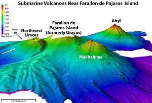
In the area of Farallón de Pájaros are two submarine volcanoes: The Makhahnas Seamount located about 10 km (6.2 mi) southwest, reaching a height of 640 m (2,100 ft) below sea level, and last erupted in 1967. The Ahyi Seamount located about 18 km (11 mi) south-east and reaches a height of 137 m (449 ft) below sea level. It is associated with a possible eruption in 1979, an eruption in 2001, and a series of underwater eruptions from 24 April to 17 May 2014, with hydrothermal activity continuing at least to December 2014.[3]
History
Presumably Farallon de Pajaros was never permanently inhabited.
From 1899 to 1914, Farallón de Pájaros was controlled by the German Empire and was administered as part of the colony of German New Guinea. In 1903 the island was leased to a Japanese company, which hunted birds whose feathers were exported to Japan and then to Paris.[4]
After World War I, the island was awarded to the Empire of Japan, by the League of Nations as part of the South Seas Mandate. After World War II, Farallón de Pájaros was awarded to the United States as part of the UN Trust Territory of the Pacific Islands, and is currently administered as part of the Northern Islands Municipality of the Commonwealth of the Northern Mariana Islands.
In 1985, per the Constitution of the Commonwealth of the Northern Mariana Islands, the island was designated as a wilderness area for the protection and conservation of natural resources. Since 2009, the island has been part of Marianas Trench Marine National Monument of the United States.[5]
References
- Horst Lehne and Christoph Gäbler: Über die Marianen. Lehne-Verlag, Wohldorf in Germany 1972.
- Russell E. Brainard et al.: Coral reef ecosystem monitoring report of the Mariana Archipelago: 2003–2007. (=PIFSC Special Publication, SP-12-01) NOAA Fisheries, Pacific Islands Fisheries Science Center 2012 (Kapitel Farallon de Pajaros (englisch, PDF, 10,4 MB)).
Notes
- Brainard, Coral reef ecosystem monitoring report, S. 1.
- "Farallón de Pájaros". Global Volcanism Program. Smithsonian Institution. Retrieved 2020-01-09.
- "Ahyi". Global Volcanism Program. Smithsonian Institution. April 2017. Retrieved 3 February 2020.
Global Volcanism Program, 2017. Report on Ahyi (United States) (Crafford, A.E., and Venzke, E., eds.). Bulletin of the Global Volcanism Network, 42:4. Smithsonian Institution. https://doi.org/10.5479/si.GVP.BGVN201704-284141.
- Gerd Hardach: König Kopra. Die Marianen unter deutscher Herrschaft 1899–1914. Steiner, Stuttgart 1990, ISBN 3-515-05762-5, S. 133f.
- Brainard, Coral reef ecosystem monitoring report, S. 4.
External links
| Wikimedia Commons has media related to Farallon de Pajaros. |
| Colonies |
| |||||
|---|---|---|---|---|---|---|
| Concessions |
| |||||
| Unrecognised |
| |||||