Umhlanga, KwaZulu-Natal
Umhlanga is an affluent residential, commercial and resort town north of Durban on the coast of KwaZulu-Natal, South Africa. It is part of the eThekwini Metropolitan Municipality, created in 2000, which includes the greater Durban area. The name means "place of reeds" in the Zulu language, and the correct pronunciation of "hl" in Umhlanga is similar to the Welsh "ll". It is bordered by Durban North to the south and Mt Edgecombe to the west.
Umhlanga | |
|---|---|
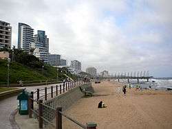 View of the skyline and beach of Umhlanga Rocks in 2011 | |
 Umhlanga  Umhlanga | |
| Coordinates: 29°43′31″S 31°05′09″E | |
| Country | South Africa |
| Province | KwaZulu-Natal |
| Municipality | eThekwini |
| Government | |
| • Councillor | Heinz de Boer (DA) |
| Area | |
| • Total | 16.75 km2 (6.47 sq mi) |
| Population (2011)[1] | |
| • Total | 24,238 |
| • Density | 1,400/km2 (3,700/sq mi) |
| Racial makeup (2011) | |
| • Black African | 17.1% |
| • Coloured | 2.1% |
| • Indian/Asian | 26.2% |
| • White | 53.3% |
| • Other | 1.2% |
| First languages (2011) | |
| • English | 78.9% |
| • Zulu | 9.0% |
| • Afrikaans | 6.1% |
| • Xhosa | 1.1% |
| • Other | 4.9% |
| Time zone | UTC+2 (SAST) |
| Postal code (street) | 4319 |
| PO box | 4320 |
It is well known for the Gateway Theatre of Shopping which is the largest shopping mall in the southern hemisphere.[2] It also has the second tallest skyscraper in South Africa named Pearl Sky which stands 183 meters high. There are two beaches: Bronze Beach and Main Beach, both of which are patrolled by lifeguards throughout the day. Umhlanga is one of the fastest-growing cities in South Africa – the population increased 57.5% from 15,387 in the 2001 census to 24,238 in the 2011 census.
In the same way that Sandton, Gauteng is becoming the financial centre of Johannesburg, Umhlanga is becoming the main economic hub of Durban.[3]
History
Umhlanga derives its name from the Zulu language and means "place of reeds", referring to the beds of reeds growing along the Ohlanga River north of Umhlanga Rocks.[4][5]
The Oyster Box, a luxury hotel since the 1950s, was originally built as a beach cottage in 1869, before the town had even been founded.
In 1895, Sir Marshall Campbell founded Umhlanga. The town's first hotel was established in 1920, followed by a shop, a lighthouse, the Natal Anti Shark Measures Board (today called the KwaZulu-Natal Sharks Board) and further hotel developments.[6][7]
The Borough of Umhlanga was formed on 1 August 1972 through the amalgamation of Umhlanga Rocks, a seaside resort town, and the suburb of La Lucia. Mr Rodney Rindel, former chairman of the La Lucia town board, was elected to mayor of the newly formed Borough of Umhlanga. Mr Rindel said that the people of La Lucia had made no secret that they were opposed to the amalgamation and were not happy with the name, but now that this had come about they would make the best of it.

In the 1980s, development expanded inland growing from a small village east of the M4 highway to a large town occupying most of the area east of N2 highway and south of the Hawaan Forest.[6] The city is seeing expansion into areas near the Hawaan forest to the north which is the natural habitat of many creatures such as the vervet monkey. The monkeys often venture into the city in search of food from residents and unsuspecting tourists.
Current developments
Umhlanga, specifically the former sugarcane fields of Umhlanga Ridge, has become the focus of development in the greater Durban area with many businesses relocating offices from central Durban (similarly to Sandton forming the new centre of Johannesburg), a move that has been criticized for "fragmenting the urban fabric" and furthering "the new apartheid" in Durban.[6] In 2010, Durban International Airport was moved to La Mercy, near Umhlanga, and reopened as King Shaka International Airport.
Due to the economic boom in the Umhlanga area as well as the new airport located nearby, various developments are under way which will substantially increase the population over the next two decades.
About 6 kilometres (3.7 mi) up the coast will be the luxury Aerotropolis known as the Sibaya Coastal Precinct inland to Umdloti[8] It is estimated that it will cost R25-50 billion to develop and will. It will include around 9000 houses as well as numerous social and public facilities.[9]
The new town centre around gateway has seen major expansion with many apartment complexes and businesses being built. The estimated R25 billion Cornubia development is being built across the N2 from the new town centre and will include 24000 low and middle income houses.[10] In late 2017 the R1,8 billion Cornubia Mall opened to the public.[11]
In the Umhlanga village, Pearl Sky was completed in 2017 and includes a shopping mall. There is also the Oceans Umhlanga development which will include 3 large buildings, 2 of which are 28 story apartment complexes and the third a 5 star Radisson Blu hotel. There will be 100 shops on the lower floors and it is expected to be completed in 2018. At a price of R3,1 billion this is the largest private sector investment in South African history narrowly beating the Pearls of Umhlanga at R3,0 billion. It is being built inland and adjacent from the recently constructed Pearls of Umhlanga.[12]
Umhlanga Rocks

Umhlanga Rocks has many luxury hotels and apartments right on the beach, including the Cabana Beach Hotel, the Beverly Hills Hotel, the Oyster Box Hotel, the Umhlanga Sands Hotel and Pearls of Umhlanga apartments. Many of these have views of the landmark lighthouse. It has a large increase in population during the summer months.
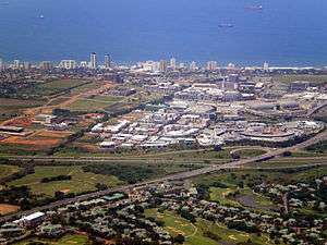
Umhlanga Ridge
Umhlanga Ridge is a new retail, office and residential node situated on a hill overlooking the Indian Ocean. It was largely developed on sugarcane land by property development company, Moreland Estates, owned by the Tongaat Hulett sugar group. Located on the ridge are Gateway Theatre of Shopping and other shopping centres, motor dealerships, a private hospital and many offices.
Umhlanga Ridge Town Centre is connected by a series of pedestrian-friendly roads, parks and public spaces. The Town Centre is easily accessed by a network of major roads, including the N2.
The Umhlanga Ridge New Town Centre has been under construction for almost a decade. Vela VKE consulted on the structural input for the design of the grade separation bridge and two parking court structures. Civil infrastructure costs amount to R200 million to date.
Tourism
Together, Umhlanga and Umdloti form the Sugar Coast of KwaZulu-Natal. Umhlanga is one of the most popular tourist destinations in South Africa. There were 1.2 million visitors in 2015 which generated a GDP of R20-billion. In 2016, the tourism chairman Peter Rose said “I can confidently say that within the next five years you will not recognise uMhlanga,” Residents of Umhlanga have mixed feelings about the changes such as that it is losing its village appeal while they appreciate the new infrastructure and increased property values.[13]
Other places of interest in Umhlanga are the Umhlanga Country Club and The Mount Edgecombe Country Club in nearby Mount Edgecombe.
Crime
Umhlanga is one of the safest areas in the Durban area. The Durban North precinct which includes a small slice along the coast of Durban North, all of Umhlanga and Umdloti maintained a murder rate of around 7 per 100,000 from 2016–2019, about 1/5 of the national average of 35.9 in 2017.[14][15] Between March 2018 – 2019, police recorded 3 murders, 136 robberies and 318 residential burglaries. The number of residential burglaries halved between 2014 and 2019 possibly linked to the proliferation of highly visible private security in the area. Certain areas in Umhlanga are very safe, one being Somerset park, a short distance from the Gateway mall.
Demographics
Umhlanga is very diverse with people from various racial backgrounds and ethnic groups. 78.9% speak English as their first language, 9.0% Zulu and 6.12% Afrikaans. There is also a sizable Portuguese population.
The number of people from each racial group increased between 2001 and 2011. The number of white people increased from 11,523 to 12,925 while the percentage dropped from 74.9% to 53.3%. The number of black people increased from 1,770 to 4,147. The number of 'Indians or Asians' increased from 1,953 to 6,353. The number of coloureds increased from 141 to 297.[1][16]
As of the 2011 census, the most black area is the new town centre area which is 24.1% black.[17] The most white area is the northern coastal area including the Umhlanga village which is 66.9% white.[18] The most Indian area is the woodlands which is 46.0% Indian.[19] The expensive new developments tend to have higher Indian populations than the average for Umhlanga while the lower cost developments tend to have higher Indian and black populations than the average. The older parts of Umhlanga tend to have higher white populations than the average.
See also
References
- "Main Place Umhlanga". Census 2011.
- "Gateway Theatre of Shopping". gatewayworld.co.za. Retrieved Apr 1, 2020.
- "Leading financier opens doors in thriving KZN" (Press release). Business Partners Limited. 29 September 2015. Retrieved 2016-08-15.
- "African languages: Meanings of place names in South Africa". Africanlanguages.com. 2006. Retrieved 5 January 2016.
- "Umhlanga Tourism Information Centre". UmhlangaTourism.co.za. Retrieved 5 January 2016.
- http://eprints.qut.edu.au/2238/1/2238_1.pdf
- "Umhlanga Rocks history | Umhlanga Rocks information | KZN". www.kznnorthhappenings.co.za. Retrieved Apr 1, 2020.
- "Sibaya Coastal Precinct - A Tongaat Hulett Property". Sibaya Coastal Precinct. Retrieved Apr 1, 2020.
- "KZN's R50bn Sibaya Coastal Precinct officially launched – Property Wheel". propertywheel.co.za. Retrieved Apr 1, 2020.
- "R1.8-billion Cornubia Mall opens to the public". Northglen News. 2017-09-28. Retrieved 2019-05-21.
- "Video: R3.1 bn Umhlanga development". www.iol.co.za. Retrieved Apr 1, 2020.
- "Face of uMhlanga set to change". Aug 30, 2016. Retrieved Apr 1, 2020.
- "South Africa Homicide rate, 1990-2019 - knoema.com". Knoema. Retrieved Apr 1, 2020.
- "Census 2001 — Main Place "Umhlanga"". census2001.adrianfrith.com. Retrieved Apr 1, 2020.
- "Census 2011: Sub Place: Umhlanga Ridge". census2011.adrianfrith.com. Retrieved Apr 1, 2020.
- "Census 2011: Sub Place: Umhlanga SP". census2011.adrianfrith.com. Retrieved Apr 1, 2020.
- "Census 2011: Sub Place: Strattton-on-Sea". census2011.adrianfrith.com. Retrieved Apr 1, 2020.
External links
- Official tourism site
- Umhlanga Ridge Town Centre photo gallery
- The Umhlanga Magazine
- Umhlanga's Online Newspaper
- Umhlanga Hotels
| Authority control |
|
|---|