Ubagan
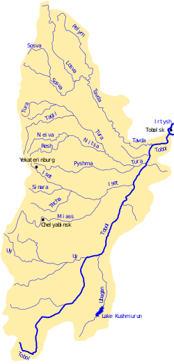
The Ubagan (Kazakh: Обаған Obaǵan; Russian: Убаган) is a river of Kazakhstan and Russia, a right tributary of the Tobol. It has a length of 376 km (234 mi), and a catchment area of 50,700 km2 (19,600 sq mi),[1] with water supplied by melting snow. In the summer the water is brackish.
| Ubagan | |
|---|---|
 Ubagan in the Tobol basin | |
| Location | |
| Country | Kazakhstan, Russia |
| Physical characteristics | |
| Source | |
| • location | Karachinskoe/lake |
| Mouth | Tobol |
• coordinates | 54°24′02″N 64°45′01″E |
| Length | 376 km (234 mi) |
| Basin size | 50,700 km2 (19,600 sq mi) |
| Basin features | |
| Progression | Tobol→ Irtysh→ Ob→ Kara Sea |
Course
It flows from the lake Karachinsky. Flows to the North at Turgay valley, in the upper reaches flows through the lake Kushmurun. The river empties into the Tobol on the right side in 909 km from its mouth.
History
About Abagana present article in ASBE:
Ubagan river Akmola and Turgay regions (Obagi) is a right tributary of the Tobol river; originates in the southern slopes of the mountains Kosharovsky in Akmola region and in the upper reaches bears the title Burduli-Tal. Reaching Turgay area, Ubagan flows directly to the North, serving as a border between the Turgai and Akmolinsk regions about 200 miles, and in this way passes through a large lake Ubagan. Then, a short 60 miles to the Northern edge of the region, the river is deflected to the West and flows into the Tobol already from Orenburg province, 10 versts from the village of Zverinogolovskoe. Abagana width in some places reaches 20 fathoms; convenient fords is not a lot, the best of them Kara-Utkul (black Ford) Baggalini on the caravan route, near the confluence of the brook, Asibus. Tributaries, noteworthy, Ubagan is not. Water all over Abagana salt or bitter-salt.
References
- Река Убаган in the State Water Register of Russia (Russian)