U1 (Nuremberg U-Bahn)
U1 | |||||||||||||||||||||||||||||||||||||||||||||||||||||||||||||||||||||||||||||||||||||||||||||||||||||||||||||||||||||||||||||||||||||||||||||||||||||||||||||||||||||||||||||||||||||||||||||||||||||||||||||||||||||||||||||||||||||||||||||||||||||||||||||||||||||||||||||||||||||||||||||||||||||||||||||||||||||||||||
|---|---|---|---|---|---|---|---|---|---|---|---|---|---|---|---|---|---|---|---|---|---|---|---|---|---|---|---|---|---|---|---|---|---|---|---|---|---|---|---|---|---|---|---|---|---|---|---|---|---|---|---|---|---|---|---|---|---|---|---|---|---|---|---|---|---|---|---|---|---|---|---|---|---|---|---|---|---|---|---|---|---|---|---|---|---|---|---|---|---|---|---|---|---|---|---|---|---|---|---|---|---|---|---|---|---|---|---|---|---|---|---|---|---|---|---|---|---|---|---|---|---|---|---|---|---|---|---|---|---|---|---|---|---|---|---|---|---|---|---|---|---|---|---|---|---|---|---|---|---|---|---|---|---|---|---|---|---|---|---|---|---|---|---|---|---|---|---|---|---|---|---|---|---|---|---|---|---|---|---|---|---|---|---|---|---|---|---|---|---|---|---|---|---|---|---|---|---|---|---|---|---|---|---|---|---|---|---|---|---|---|---|---|---|---|---|---|---|---|---|---|---|---|---|---|---|---|---|---|---|---|---|---|---|---|---|---|---|---|---|---|---|---|---|---|---|---|---|---|---|---|---|---|---|---|---|---|---|---|---|---|---|---|---|---|---|---|---|---|---|---|---|---|---|---|---|---|---|---|---|---|---|---|---|---|---|---|---|---|---|---|---|---|---|---|---|---|---|---|---|---|---|---|---|---|---|---|---|---|---|---|---|---|---|---|---|
| |||||||||||||||||||||||||||||||||||||||||||||||||||||||||||||||||||||||||||||||||||||||||||||||||||||||||||||||||||||||||||||||||||||||||||||||||||||||||||||||||||||||||||||||||||||||||||||||||||||||||||||||||||||||||||||||||||||||||||||||||||||||||||||||||||||||||||||||||||||||||||||||||||||||||||||||||||||||||||
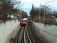
The U1 is an underground line in Nuremberg. The line was opened on 1 March 1972. The stretch is about 18,5 km long. The Number of stations is 27. The start-and endstations are Langwasser Süd and Fürth Hardhöhe. Until 11 December 2016 it shared tracks with the former boot line U11 between Eberhardshof and Messe. Unlike U2 and U3 all trains are operated by a driver and there are no plans to automate U1.
Line Design
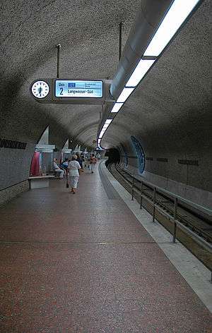
The route begins at the Langwasser Süd station, at the southern end of which a four-track parking and sweeping system is located, and initially runs underground above the community building to Langwasser Mitte station. Thereafter, the route reaches the street level and henceforth runs in the median strip of Otto-Bärnreuther-Straße on the route of a planned in the 1950s tram line. In front of the next station Scharfreiterring the access to the underground depot is undercut. The station itself has four tracks, of which the two outer ones are used for passenger traffic and the two inner ones for entry and exit trips to and from the depot. The route continues past the railway stations Langwasser Nord and Messe until the last station of the first subway construction section, Bauernfeindstraße.
Between fair and Bauernfeindstraße the subway passes through the narrowest in scheduled traffic busy curve in the Nuremberg subway network, which is also due to the former streetcar planning. The maximum speed allowed in this area is 50 km / h. Afterwards, the route dips into a tunnel that was the longest between two underground stations in Nuremberg until the opening of the section Brick - Airport on the U2, and underfires the Südbahnhof area. Shortly after the Brunecker Straße, the track reappears on the surface and runs in the terrain cut to Hasenbuck station.
After the Hasenbuck station, the now underground route leads under the eponymous survey and the Katzwanger road to the station Frankenstraße and then runs under the Pillenreuther road to the station Maffeiplatz. The route continues from the Maffeiplatz under the Pillenreuther Straße to the Kopernikusplatz and reaches the station Aufseßplatz. This was prepared during construction on the underpass by another subway line (then called U3) by the tunnel tubes of the U1 are built so that the construction of the track tunnel is possible without major operational restrictions. The route continues under the tracks of the main station to the main train station under the station square, where the U1 meets the U2 and U3 for the first time.
Then the route leads in an elongated left bend under Königstraße to the Lorenzkirche train station and then under Adlerstraße, Josephs and Ludwigsplatz to the station Weißer Turm. This section of the route was the most technically demanding of the entire Nuremberg subway, as both the central hall of the main station and significant historic buildings of the old town are undercut. Running under the Jakobsplatz and the Ludwigstraße, the line of the U1 reaches the station Plärrer and meets there for the second time on the U2 and U3. The station is designed as a direction station, in the upper station level the trains go in the direction of Fürth (U1), Röthenbach (U2) and Gustav-Adolf-Straße (U3) and in the lower level direction Langwasser (U1), airport (U2) and Northwest Ring (U3). After the Plärrer station the U1 follows the historic Ludwigseisenbahn route (today however below the Fürther road), passes the stations Gostenhof, Bärenschanze and Maximilianstrasse and reaches in the height of the Raabstraße before the station Eberhardshof again the surface.
The station Eberhardshof itself, is located in the middle of the Fürther Straße. It is adjoined by the last parking and sweeping system of the U1 existing in Nuremberg. After crossing the Ringbahn, the route leads up the elevated railway line in a ramp construction to the first Muggenhof station. This spans the intersection Fürther Straße / Adolf-Braun-Straße / Sigmundstraße in full length and, like the station Stadtgrenze, has outer platforms. The route continues in the middle position of the Fürther Straße, before crossing the Frankenschnellweg in an S-Bahn and reaching the station located on a dam city boundary. This is already located on the city of Fürth, but is counted to the Nuremberg subway network, since its construction was completely funded by the city of Nuremberg.
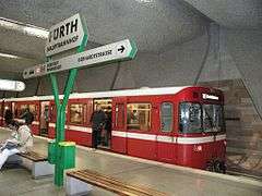
After the railway station Stadtgrenze, the route initially runs parallel to the Hornschuch promenade on a causeway, then dives into the subsoil by means of a ramp construction and reaches the station Jakobinenstraße. Following Gebhardtstraße in the course of the underground station Furth Hauptbahnhof is reached under the station square, which was opened on 7 December 1985 for the 150th anniversary of the railway in Germany. Afterwards, the route swings to the north, runs under the Schwabacher Straße to the coal market and reaches the station Fürth Rathaus. The route then leads under the Gänsbergviertel and the Rednitz through the station Fürth Stadthalle and in the further course under the Scherbsgraben and Kellerberg to the station Fürth Klinikum. Afterwards, the Nuremberg-Bamberg railway line and the Würzburger Straße are underpassed before the line swings to the southwest and runs under the Komotauer Straße and reaches the terminus Fürth Hardhöhe. From the Fürth Rathaus station, digital displays were used for the first time at the platforms instead of the previous case-sheet advertisements.
Stations
| Stations | Transfers |
|---|---|
| U1 | |
| Langwasser Süd ↑ | |
| Gemeinschaftshaus | |
| Langwasser Mitte | |
| Scharfreiterring ↑ | |
| Langwasser Nord | |
| Messe ↑ | |
| Bauernfeindstraße | |
| Technische Universität | planned |
| Hasenbuck ↑ | |
| Frankenstraße | |
| Maffeiplatz | |
| Aufseßplatz ↑ | |
| Hauptbahnhof | |
| Lorenzkirche | |
| Weißer Turm | |
| Plärrer | |
| Gostenhof ↓ | |
| Bärenschanze | |
| Maximilianstraße | |
| Eberhardshof ↓ | |
| Muggenhof | |
| Stadtgrenze | |
| Jakoninenstraße | |
| Fürth Hauptbahnhof | |
| Fürth Rathaus | |
| Fürth Stadthalle | |
| Fürth Klinikum | |
| Fürth Hardhöhe ↓ | |
| Fürth Kieselbühl | originally planned but de facto cancelled |
Destination stations are bold. ↑ Means that this station is a southern destination, ↓ means that it is a western destination.
Opening dates

- 1 March 1972: Langwasser Süd ↔ Bauernfeindstraße
- 18 June 1974: Bauernfeindstraße ↔ Frankenstraße
- 23 September 1975: Frankenstraße ↔ Aufseßplatz
- 28 January 1978: Aufseßplatz ↔ Weißer Turm
- 20 September 1980: Weißer Turm ↔ Bärenschanze
- 20 June 1981: Bärenschanze ↔ Eberhardshof
- 20 March 1982: Eberhardshof ↔ Jakobinenstraße
- 7 December 1985: Fürth Jakobinenstraße ↔ Fürth Hauptbahnhof
- 4 December 1998: Fürth Hauptbahnhof ↔ Fürth Stadthalle
- 5 December 2004: Fürth Stadthalle ↔ Fürth Klinikum
- 9 December 2007: Fürth Klinkum ↔ Fürth Hardhöhe
Planned extensions
There are no detailed plans for any extension of the line. However, there have in the past been plans for an extension towards Fürth Kieselbühl, which are however conditioned on future infill development at that site which has been put off for the time being. On the other end of the line U1 was started at Langwasser and built "inwards" and Langwasser remains the terminus with no planned extensions. Branching extensions have been put forward variously but as of 2018 none are likely to be built for the foreseeable future.
See also
| Wikimedia Commons has media related to U1 (Nürnberg). |
- Nuremberg U-Bahn
- U2 (Nuremberg U-Bahn)
- U3 (Nuremberg U-Bahn)
- Nuremberg S-Bahn
- S1 (Nuremberg)
- S2 (Nuremberg)
- S3 (Nuremberg)
- S4 (Nuremberg)
