U.S. Route 40 in West Virginia
In the U.S. state of West Virginia, U.S. Route 40 (US 40) runs for 16 miles (26 km) through the Northern Panhandle region. The highway enters the state on the Military Order of the Purple Heart bridge concurrent with US 250, crossing Wheeling Island, before joining Interstate 70 (I-70) over the Fort Henry Bridge before leaving the interstate. The highway travels north around Wheeling Hill, before traveling through the northeastern suburbs of Wheeling, Triadelphia and Valley Grove before entering Pennsylvania. A majority of the route still follows the old National Road which predates the U.S. Highway System.
| ||||
|---|---|---|---|---|
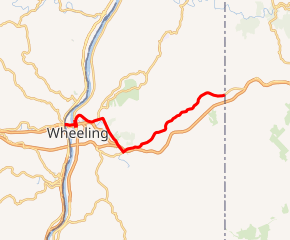
US 40 highlighted in red | ||||
| Route information | ||||
| Maintained by WVDOH | ||||
| Length | 16.0 mi[1] (25.7 km) | |||
| Major junctions | ||||
| West end | ||||
| East end | ||||
| Location | ||||
| Counties | Ohio | |||
| Highway system | ||||
| ||||

Route description
_at_Mount_Wood_Road_in_Wheeling%2C_Ohio_County%2C_West_Virginia.jpg)
History
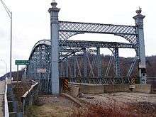
Before the construction of I-70, US 40 continued southeast along Zane Street to Virginia Street, crossing the east channel of the Ohio River on the Wheeling Suspension Bridge.
Major intersections
The entire route is in Ohio County.
| Location | mi[1] | km | Destinations | Notes | |
|---|---|---|---|---|---|
| Wheeling (Wheeling Island) | Ohio state line (Military Order of the Purple Heart Bridge over Ohio River back channel) | ||||
| 0.35 | 0.56 | Western end of I-70 concurrency; westbound exit and eastbound entrance; US 40 west follows exit 0 | |||
| Wheeling | 0.63 | 1.01 | Fort Henry Bridge over Ohio River | ||
| 0.79 | 1.27 | Eastern end of I-70 / US 250 concurrency, western end of WV 2 concurrency; US 40 east follows exit 1A | |||
| Eastern end of WV 2 concurrency | |||||
| I-70 exit 2A | |||||
| Western end of WV 88 concurrency | |||||
| I-70 exit 4 | |||||
| Eastern end of WV 88 concurrency | |||||
| I-70 exit 5 | |||||
| Triadelphia | |||||
| Roneys Point | |||||
| Valley Grove | |||||
| | |||||
| | east end of National Road overlap | ||||
| | Pennsylvania state line | ||||
1.000 mi = 1.609 km; 1.000 km = 0.621 mi
| |||||
References
- Google (February 11, 2011). "US Route 40 in West Virginia" (Map). Google Maps. Google. Retrieved February 11, 2011.
External links
| Wikimedia Commons has media related to U.S. Route 40 in West Virginia. |
| Previous state: Ohio |
West Virginia | Next state: Pennsylvania |