Tweed, Ontario
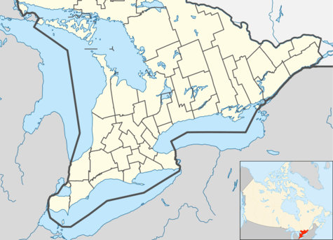
Tweed is a municipality located in central-eastern Ontario, Canada, in Hastings County.
- This page is about the Municipality of Tweed, for the village see Tweed, Ontario (village).
Tweed | |
|---|---|
| Municipality of Tweed | |
 Main street in Tweed | |
 Tweed | |
| Coordinates: 44°36′N 77°20′W | |
| Country | |
| Province | |
| County | Hastings |
| Incorporated | 1998 |
| Government | |
| • Type | Municipality |
| • Mayor | Jo-Anne Albert |
| • Federal riding | Prince Edward—Hastings |
| • Prov. riding | Prince Edward—Hastings |
| Area | |
| • Land | 953.47 km2 (368.14 sq mi) |
| Population (2016)[1] | |
| • Total | 6,044 |
| • Density | 6.3/km2 (16/sq mi) |
| Time zone | UTC-5 (EST) |
| • Summer (DST) | UTC-4 (EDT) |
| Postal Code | K0K |
| Area code(s) | 613 |
| Website | twp.tweed.on.ca |
History
The Municipality of Tweed is an amalgamated municipality comprising the former Village of Tweed and the former Hungerford Township and former Elzevir & Grimsthorpe Townships. The Municipality was incorporated on 1 January 1998 as a lower tier municipality within the County of Hastings two tier governing system.
The post office was established in 1852.[2]
Elzevir Township (formed circa 1869,[3] location of a major gold strike[4]) and Grimsthorpe Township (formed 22 February 1867 during the local gold rush)[5] had been administered as one entity since before 1968[6] until amalgamation into the Municipality of Tweed.
As of 2004, the total land area was approximately 230,000 acres (930 km²), 30% of which was Crown land. Lakes, rivers and streams account for approximately 4,650 acres (18 km²). There are approximately 600 kilometres (370 mi) of roads throughout the Municipality. The total 2004 property assessment for the Municipality of Tweed was $309,000,000. Its composition was 84% residential, 7% farm, 6% commercial and industrial, and 3% other categories.
A primary attraction in the Municipality of Tweed is a vacation destination located at 115 Varty Road, with cottages and campsites along the Skootamatta River, a part of the Moira River system. From 2000, it was managed as Tipper's Family Campground,[7] run by the family of Canadian violist, Jayden Tipper. Purchased by the Haid family in 2018, it is managed as Haid's Hideaway Family Campground.[8]
Immediately east of the Village of Tweed is Stoco Lake, home to a popular and uncommon sport-fish, the muskellunge or Muskie (Esox masquinongy). Stoco Lake is a part of the Moira River system; the Black River joins the Moira River near the Village of Tweed.
The Napanee, Tamworth and Quebec Railway (later the Bay of Quinte Railway) had a spur from Tamworth, Ontario to Tweed; the Tweed-Yarker and Tweed-Bannockburn segments were abandoned by 1941 and the former Napanee-Smiths Falls mainline abandoned in the late 1970s. From the 1880s, the Canadian Pacific Railway's Havelock Subdivision passed through Tweed to Glen Tay and Smith Falls. The line was abandoned from Glen Tay to Tweed in 1973 then Tweed to Havelock in 1987. A more westerly portion of the line still runs through Peterborough.
Communities
Besides the village proper of Tweed, the Municipality of Tweed comprises a number of villages and hamlets, including the following communities such as Actinolite, Bogart, Buller, Chapman, Cosy Cove, Coulters Hill, Duff Corners, East Hungerford (44.502°N 77.151°W), Elzevir, Farrell Corners (44.452°N 77.134°W), Hungerford, Larkins, Lime Lake, Lodgeroom Corners, Lost Channel (44.419°N 77.316°W), Marlbank, Moneymore, Otter Creek, Queensborough, Stoco, Sulphide, and Thomasburg (44.388961°N 77.345896°W [9])
Approximately 30% of the population resides in the Village of Tweed, the only urban center. The remainder of the Municipality of Tweed consists of a large rural area which reaches from Wadsworth Lake in the north to Roslin in the south containing five hamlets: (Actinolite, Marlbank, Queensborough, Stoco, and Thomasburg. The residents of the hamlets and the rural area comprise the other 70% of the population. In 2004, there were approximately 2870 households.
Demographics
| Canada census – Tweed, Ontario community profile | |||
|---|---|---|---|
| 2016 | 2011 | 2006 | |
| Population: | 6044 (-0.2% from 2011) | 6057 (7.9% from 2006) | 5614 (0.0% from 2001) |
| Land area: | 953.47 km2 (368.14 sq mi) | 953.75 km2 (368.24 sq mi) | 896.98 km2 (346.33 sq mi) |
| Population density: | 6.3/km2 (16/sq mi) | 6.4/km2 (17/sq mi) | 6.3/km2 (16/sq mi) |
| Median age: | 51.3 (M: 51.1, F: 51.5) | 48.7 (M: 48.0, F: 49.4) | 44.8 (M: 44.4, F: 45.3) |
| Total private dwellings: | 3023 | 2907 | 2709 |
| Median household income: | $54,549 | $46,519 | |
| References: 2016[1] 2011[10] 2006[11] earlier[12] | |||
| Historical population | ||
|---|---|---|
| Year | Pop. | ±% |
| 1996 | 5,706 | — |
| 2001 | 5,612 | −1.6% |
| 2006 | 5,614 | +0.0% |
| 2011 | 6,057 | +7.9% |
| 2016 | 6,044 | −0.2% |
| [13] | ||
Populations prior to amalgamation (1998):
- Total Population in 1996: 5,706
- Elzevir and Grimsthorpe township: 854
- Hungerford township: 3,280
- Tweed village: 1,572
- Population in 1991:
- Elzevir and Grimsthorpe township: 781
- Hungerford township: 3,085
- Tweed village: 1,626
Mother tongue:[14]
- English as first language: 95.8%
- French as first language: 0.8%
- English and French as first language: 0.4%
- Other as first language: 3.0%
Forest fire protection history
The Tweed Forest Fire District was founded by the former Ontario Department of Lands and Forests (now the MNR) in 1922 as one of 17 districts to help protect Ontario's forests from fire by early detection from fire towers. The headquarters for the district were housed at Hungerford Road in town. It was the central headquarters for 21 fire lookout towers. When a fire was spotted in the forest a towerman would get the degree bearings from his respective tower and radio back the information to headquarters. When one or more towermen from other towers in the area would also call in their bearings, the forest rangers at headquarters could get a 'triangulation' read and plot the exact location of the fire on their map. This way a team of forest firefighters could be dispatched as soon as possible to get the fire under control. In 1958 the 100-foot (30 m)-tall Hungerford firetower was erected beside the station. However, in the 1970s all the towers had been decommissioned as aerial firefighting techniques were employed. The Hungerford tower was disassembled in 1996 and placed behind the Tweed Heritage Centre.
Notable stories
- Tweed made national news in 2010 when Colonel Russell Williams, a resident of Ottawa who had a cottage in Tweed, was arrested and accused of the murders of Jessica Lloyd and Corporal Marie-France Comeau. Williams was convicted in 2010 and received two life sentences for the first-degree murders. Williams is in prison in Kingston, Ontario.
- One of Tweed's former claims to fame was that it had the smallest jailhouse in the province. Although its jail (4.9 meters x 6.1 meters) is indeed one of the smallest, other towns in the province have come forward with similar or smaller dimension jails. These include: Berens River, Providence Bay, Ontario, Port Dalhousie, Ontario, Rodney, Ontario, Coboconk and Creemore, Ontario. Today, the Tweed jail has been converted into a tourist information center.
- In 1996 the town made news when it applied for a CFL team, in an attempt to become the Green Bay of Canada. Had the attempt been successful, the team would have been known as the Tweed Muskies.
- In 1989 the Ottawa branch of the Elvis Sighting Society declared Elvis was alive and well and living in Tweed. For several years after that, an Elvis is Alive festival was held in July. Tweed and Elvis made the headlines when a reporter from the Toronto Sun came to investigate if there was truth to the rumors. The only evidence that remains now that Elvis may have ever been in the community is a very short road now called Elvis Lane. Oddly enough not far from the proposed site of the Tweed Muskies stadium. An Elvis festival still takes place every year near the end of August.
- Tweed is the home of Tweed & Company Theatre, a critically acclaimed producer of original Canadian musical theatre. Founded in 2007, Tweed & Company have produced many successful seasons in Tweed. Tweed & Co. operates in the Marble Arts Centre in Actinolite, a building owned and operated by the Tweed and Area Arts Council, as well as at pop up locations across the region and around the province. They are a professional musical theatre company whose past performers have included Melissa O'Neil (Canadian Idol), and Loretta Bailey (Original Canadian Cast of Les Mis) to name a few. Tweed and Company have been largely recognized for their original work including several BroadwayWorld awards, local commendations, and Artistic Director Tim Porter was nominated for the Premier's award of Ontario.
- In August 2017 a partial solar eclipse was visible from Tweed Ontario. This was the first partial solar eclipse visible in Tweed since 1970.
- On December 14, 2017, a Hydro One helicopter working on a row of transmission towers crashed northeast of Tweed. All 4 people on board, the pilot and three electrical workers, were killed.
See also
References
- "2016 Community Profiles". 2016 Canadian Census. Statistics Canada. February 21, 2017. Retrieved 2017-10-12.
- Hamilton, William (1978). The Macmillan Book of Canadian Place Names. Toronto: Macmillan. p. 176. ISBN 0-7715-9754-1.
- Map of Elzevir Township circa 1869 (Creation). By MacLeod and Carre, P.L.S. (1861-1867). Repository: Community Archives of Belleville and Hastings County. Accessed 31 May 2020.
- Elzevir – gold strike. Hastings County Historical Society (1957-). Repository: Community Archives of Belleville and Hastings County. Accessed 31 May 2020
- Map of Grimsthorpe Township 22 February 1867 (Creation). By William Murdoch, P.L.S. (1836-1918). Repository: Community Archives of Belleville and Hastings County. Accessed 31 May 2020.
- [https://discover.cabhc.ca/elzevir-grimsthorpe-1968 Elzevir & Grimsthorpe 1968 (Creation). Hastings County Historical Society (1957-). Repository: Community Archives of Belleville and Hastings County. Accessed 31 May 2020.
- Dun and Bradstreet: Tipper's Family Campground. Accessed 31 May 2020.
- https://haidshideaway.ca Haid’s Hideaway Family Campground.] Accessed 31 May 2020.
- "Thomasburg, ON, Community Demographics". Archived from the original on June 12, 2008.
- "2011 Community Profiles". 2011 Canadian Census. Statistics Canada. July 5, 2013. Retrieved 2012-03-02.
- "2006 Community Profiles". 2006 Canadian Census. Statistics Canada. March 30, 2011. Retrieved 2012-03-02.
- "2001 Community Profiles". 2001 Canadian Census. Statistics Canada. February 17, 2012.
- Statistics Canada: 1996, 2001, 2006, 2011, 2016census
- "Clearview, Ontario (Code3543005) (table)". 2006 Census data. Statistics Canada. Retrieved 2010-12-15.
External links
| Wikivoyage has a travel guide for Tweed. |
Places adjacent to Tweed, Ontario | |
|---|---|
| Cities | 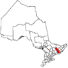 | |
|---|---|---|
| Towns | ||
| Townships | ||
| First Nations | ||
| Indian reserves | ||
| ||