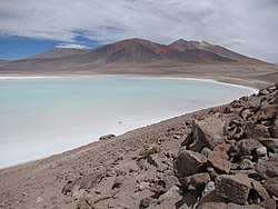
Tuyajto Lake
Tuyajto Lake is a salt lake located in the Antofagasta Region, northern Chile.[3] Located at an elevation of about 4,010 metres (13,160 ft), its surface area presently fluctuates between 1.7–2.7 square kilometres (0.66–1.04 sq mi) but in the past it was considerably larger; this led to humans going to the lake and creating archeological sites there. Presently, the lake is groundwater-fed and has no surface outlet but water might seep out underground.
| Tuyajto Lake | |
|---|---|
| Laguna Tuyajto[1] | |
 | |
| Location | Antofagasta Region |
| Coordinates | 23°56′22″S 67°35′23″W[2] |
| Type | salt lake |
| Basin countries | Chile |
| Surface area | 2.2 square kilometres (0.85 sq mi) |
| Max. depth | 0.6 metres (2.0 ft) |
| Surface elevation | 4,010 m (13,160 ft)[2] |
The lake
The lake lies at an elevation of 4,010 metres (13,160 ft).[2] It has a maximum depth of 0.6 metres (2.0 ft)[4] while its surface area is about 2.2 square kilometres (0.85 sq mi);[1] due to seasonal evaporation and the gentle slopes of the lake floor[5] it varies seasonally from 1.7 square kilometres (0.66 sq mi) in summer to 2.7 square kilometres (1.0 sq mi) in winter[6] when the lake is sometimes partially frozen over.[7] At times Tuyajto Lake is almost empty, and salts such as gypsum and halite can be seen on the edges. Wetlands occur on the eastern shores,[6] and the local flora and fauna depend on the water supply to the lake.[1] The Cordón de Puntas Negras separates Tuyajto Lake from Lejía Lake.[8]
Six[9] former shorelines occur at Tuyajto Lake, like other lakes in the region at about 3–5 metres (9.8–16.4 ft) above the current lake levels; they are considered to be remnants of late glacial shorelines, during the Lake Tauca wet period.[10] At that time between 13,800 – 9,100 calibrated radiocarbon years ago[11] or 12,800 – 10,300 years ago Tuyajto Lake was much larger, having an area of 14.6 square kilometres (5.6 sq mi)[12][13]-18 square kilometres (7 sq mi)[14] and its uppermost shoreline reached 4,080 metres (13,390 ft) elevation.[5] The former lake levels may have reached 20–40 metres (66–131 ft) above the present-day level[15] perhaps to the point of overflowing,[16] and still was about 40 metres (130 ft) deep about 8,000 years ago.[17] During the previous highstand and as lake levels dropped, a minor river delta grew on the eastern side of the lake, with additional deltas forming as lake levels decreased.[18]
Hydrology
The watershed of the lake covers an area of about 245 square kilometres (95 sq mi).[19] Springs, four of which are permanent,[1] are the main source of its water[4] which flows for some distance before reaching the lake surface; diffuse seepage of water within the wetlands and the lake itself makes up the rest of the water supply.[20] Part of the water comes from Tuyajto volcano[1] as well as Pampa Las Tecas and Pampa Colorada east and northeast from Tuyajto Lake and flows underground towards Tuyajto. In general, groundwater in the region is salty to brackish,[21] it originates as rain or snow and probably obtains salts from underground salt bodies.[22] The lake does not overflow at its surface,[4] evaporation and perhaps underground drainage towards Salar Aguas Calientes farther west are mainly responsible for removing water from the lake.[7]
Geology
The regional geology is characterized by a number of stratovolcanoes with ages ranging from Miocene to Holocene and ignimbrites of Miocene to Holocene age that form a thick layer underneath the volcanoes;[23] the Tuyajto Ignimbrite which crops out on the western and northern shores of the lake has been dated to 500,000 ± 500,000 years ago. Alluvial deposits and lake sediments occur in the whole region; the lake sediments in particular can be found south and east of Tuyajto Lake[6] and form alluvial fans on its eastern side.[17]
Tuyajto Lake lies within a 249 square kilometres (96 sq mi) endorheic basin[3] which spreads out east of the lake; west lies the Salar Aguas Calientes basin. Major mountains in the area are the 5,563 metres (18,251 ft) high Tuyajto north of the lake, 5,060 metres (16,600 ft) Incahuasi Sur southeast and 4,644 metres (15,236 ft) high Medano Volcano south-southwest of Tuyajto lake.[4] Of these, the last two are of Miocene age while Tuyajto is of Pliocene to Pleistocene age;[6] the Miocene volcanoes are weathered[17] while Tuyajto features a fumarolic patch.[22]
Climate
The climate is dry, with precipitation averaging 150–200 millimetres per year (5.9–7.9 in/year)[4] and 200–250 millimetres per year (7.9–9.8 in/year) at above 4,000 metres (13,000 ft) elevation.[1] Moisture originates from the Atlantic Ocean, the equatorial Pacific and the Gran Chaco in Argentina;[24] it falls mostly during winter unlike the rest of the Altiplano where summer precipitation dominates.[25]
Precipitation is variable both over annual and millennial timescales, with complex regional variations during El Nino and La Nina years and with past increases during the Central Andean Pluvial Events between 18,000 – 14,100 and 13,600 – 10,600 years ago, during which Lake Tuyajto rose.[17] Conversely, during some future climate change scenarios it might dry up altogether.[26] Evaporation is about 7.5–10 times larger,[4] reaching 1.5 metres per year (4.9 ft/a) at 4,000 metres (13,000 ft) elevation and decreasing with altitude. Temperatures average about 2 °C (36 °F).[17]
Human use
An Early Archaic archeological site consisting of fireplaces has been found at Tuyajto Lake; it was constructed on a former shoreline[27] and appears to relate to this shoreline.[28] Such archeological sites close to then-shorelines are common for the "Tambillo stage" of early human population in the Atacama.[29] Archeological sites at the lake have been attributed to the "Tuina occupation" between 10,820 and 8,500 years before present.[30] Younger archeological artifacts there have been dated at 8,210 – 8,130 years before present.[31]
The Andes of northern Chile have an arid climate in which a number of closed basins at elevations of over 4 kilometres (2.5 mi) contain salt lakes and salt pans. Mining and tourism are increasingly important activities in the region and together with growing agriculture and cities have resulted in increased demand for water, resulting in more research in existing water sources.[3] Reportedly, BHP obtains water from the Tuyajto Lake basin.[32]
References
- Urrutia et al. 2019, p. 2.
- Risacher, François; Alonso, Hugo; Salazar, Carlos (2003). "The origin of brines and salts in Chilean salars: a hydrochemical review". Earth-Science Reviews. 63 (3–4): 253. Bibcode:2003ESRv...63..249R. doi:10.1016/S0012-8252(03)00037-0. ISSN 0012-8252.
- Herrera et al. 2016, p. 304.
- Herrera et al. 2016, p. 305.
- Urrutia et al. 2019, p. 5.
- Herrera et al. 2016, p. 306.
- Herrera et al. 2016, p. 308.
- Convenio IREN – SERPLAC II Región (1976). "Inventario de recursos naturales por método de percepción del satélite Landsat, II Región Antofagasta. V.1 (Informe IREN N°38 V.1)" [Inventory of natural resources by Landsat satellite reconnaissance, II Region Antofagasta. V.1 (Inform IREN N°38 V.1)] (PDF). Biblioteca digital CEDOC-CIREN (in Spanish): 60. Retrieved 14 November 2018.
- Abele, G. (1989). "The influence of age, climate, and relief on the preservation of volcanic landforms in the north Chilean Andes". Bamberger Geographische Schriften. 11: 49.
- Grosjean, M.; Messerli, B.; Screier, H. (1991). "Seehochstände, Bodenbildung und Vergletscherung im Altiplano Nordchiles. Ein interdisziplinärer Beitrag zur Klimageschichte der Atacama. Erste Resultate" [Lake highstands, soil formation and glaciation in the Altiplano of Northern Chile. An interdisciplinary contribution to the climate history of the Atacama. First results.] (PDF). Bamberger Geographische Schriften (in German). 11: 102–103.
- Quade, Jay; Rech, Jason A.; Betancourt, Julio L.; Latorre, Claudio; Quade, Barbra; Rylander, Kate Aasen; Fisher, Timothy (2017). "Paleowetlands and regional climate change in the central Atacama Desert, northern chile". Quaternary Research. 69 (3): 356. doi:10.1016/j.yqres.2008.01.003. ISSN 0033-5894.
- Gayo, Eugenia M.; Latorre, Claudio; Jordan, Teresa E.; Nester, Peter L.; Estay, Sergio A.; Ojeda, Karla F.; Santoro, Calogero M. (2012). "Late Quaternary hydrological and ecological changes in the hyperarid core of the northern Atacama Desert (~21°S)". Earth-Science Reviews. 113 (3–4): 134. Bibcode:2012ESRv..113..120G. doi:10.1016/j.earscirev.2012.04.003. ISSN 0012-8252.
- Núñez & Grosjean 1994, p. 15.
- Stoertz & Ericksen 1974, p. 53.
- Grosjean, Martin; Veit, Heinz (2005). Water Resources in the Arid Mountains of the Atacama Desert (Northern Chile): Past Climate Changes and Modern Conflicts. Advances in Global Change Research. 23. p. 96. doi:10.1007/1-4020-3508-x_10. ISBN 978-1-4020-3507-4.
- Stoertz & Ericksen 1974, p. 55.
- Urrutia et al. 2019, p. 3.
- Stoertz & Ericksen 1974, p. 54.
- Risacher, François; Fritz, Bertrand (2008). "Origin of Salts and Brine Evolution of Bolivian and Chilean Salars". Aquatic Geochemistry. 15 (1–2): 128. doi:10.1007/s10498-008-9056-x. ISSN 1380-6165.
- Herrera et al. 2016, p. 307.
- Herrera et al. 2016, pp. 308–309.
- Herrera et al. 2016, p. 310.
- Herrera et al. 2016, pp. 306–307.
- Urrutia et al. 2019, pp. 2–3.
- Herrera et al. 2016, p. 314.
- Urrutia et al. 2019, p. 16.
- Núñez, Lautaro; Grosjean, Martin; Cartajena, Isabel (2001). Human Dimensions of Late Pleistocene/Holocene Arid Events in Southern South America. Interhemispheric Climate Linkages. pp. 105–117. doi:10.1016/B978-012472670-3/50010-0. ISBN 9780124726703.
- Núñez & Grosjean 1994, p. 20.
- de Souza H, Patricio (2004). "Cazadores recolectores del Arcaico Temprano y Medio en la cuenca superior del río Loa: Sitios, conjuntos líticos y sistemas de asentamientos" [Early and Middle Archaic hunter-gatherers in the upper Loa River basin: Sites, settlement systems and lithic assemblages]. Estudios Atacameños (27): 7–42. doi:10.4067/S0718-10432004002700002. ISSN 0718-1043.
- Núñez, Lautaro; Grosjean, Martin; Cartajena, Isabel (2010). "Sequential analysis of human occupation patterns and resource use in the Atacama Desert". Chungara, Revista de Antropología Chilena. 42 (2). ISSN 0716-1182.
- Hoguin, Rodolphe; Yacobaccio, Hugo D. (2012). "Análisis lítico de ocupaciones del holoceno medio de Hornillos 2 (jujuy, Argentina): discutiendo la tecnología y distribuición de las puntas de proyectil "San Martín "" [Analysis of lithics in the Mid-Holocene site Hornillos 2 (Jujuy, Argentina): Discussing the technology and distribution of the "San Martín" projectile points]. Chungará (Arica). 44 (1): 85–99. doi:10.4067/S0717-73562012000100007. ISSN 0717-7356.
- Fuenzalida, Nancy Yáñez; Otárola, Raúl Molina (2008). La gran minería y los derechos indígenas en el norte de Chile [Big mining and the rights of indigenous people in northern Chile] (in Spanish). Lom Ediciones. p. 88. ISBN 9789560000101.
Sources
- Herrera, Christian; Custodio, Emilio; Chong, Guillermo; Lambán, Luis Javier; Riquelme, Rodrigo; Wilke, Hans; Jódar, Jorge; Urrutia, Javier; Urqueta, Harry; Sarmiento, Alvaro; Gamboa, Carolina; Lictevout, Elisabeth (2016). "Groundwater flow in a closed basin with a saline shallow lake in a volcanic area: Laguna Tuyajto, northern Chilean Altiplano of the Andes". Science of the Total Environment. 541: 303–318. Bibcode:2016ScTEn.541..303H. doi:10.1016/j.scitotenv.2015.09.060. ISSN 0048-9697. PMID 26410705.CS1 maint: ref=harv (link)
- Núñez, Lautaro; Grosjean, Martin (1994). "Cambios ambientales pleistoceno-holocénicos: Ocupación humana y uso de recursos en la Puna de Atacama (Norte de Chile)" [Pleistocene-Holocene environmental changes: Human occupation and resource use in the Puna de Atacama (Northern Chile)]. Estudios Atacameños (11): 11–24. JSTOR 25674629.CS1 maint: ref=harv (link)
- Stoertz, George E.; Ericksen, George Edward (1974). "Geology of salars in Northern Chile". Professional Paper. doi:10.3133/pp811. ISSN 2330-7102.CS1 maint: ref=harv (link)
- Urrutia, Javier; Herrera, Christian; Custodio, Emilio; Jódar, Jorge; Medina, Agustín (2019). "Groundwater recharge and hydrodynamics of complex volcanic aquifers with a shallow saline lake: Laguna Tuyajto, Andean Cordillera of northern Chile". Science of the Total Environment. 697: 134116. Bibcode:2019ScTEn.697m4116U. doi:10.1016/j.scitotenv.2019.134116. ISSN 0048-9697.CS1 maint: ref=harv (link)
| Wikimedia Commons has media related to Laguna Tuyajto. |