Tullparaju
Tullparaju[2][3][1][4] (possibly from Quechua tullpa rustic cooking-fire, stove, rahu snow, ice, mountain with snow)[5][6] is a mountain in the Cordillera Blanca in the Andes of Peru, about 5,787 metres (18,986 ft) high.[2][3][1][4] It is situated in the Ancash Region, Huaraz Province, Independencia District, and in the Huari Province, Huari District.[7] Tullparaju lies southeast of the mountains Pucaranra and Chinchey and northeast of Andavite. It is situated at the end of the Quilcayhuanca valley, northeast of the lake Tullpacocha.
| Tullparaju | |
|---|---|
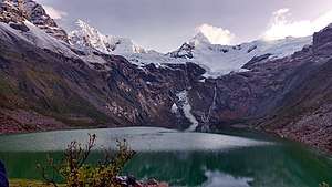 Tullparaju mountain at the center and Tullpacocha lake beneath | |
| Highest point | |
| Elevation | 5,787 m (18,986 ft) [1] |
| Coordinates | 9°24′00″S 77°19′00″W |
| Geography | |
 Tullparaju Location in Peru | |
| Location | Peru, Ancash |
| Parent range | Cordillera Blanca |
| Climbing | |
| First ascent | 1-1962 via W. ridge: E. ridge-1979[1] |
Sources
- Neate, Jill (1994). "Peru". Mountaineering in the Andes (PDF). RGS-IBG Expedition Advisory Centre. p. 12. ISBN 0-907649-64-5.
- Alpenvereinskarte 0/3b. Cordillera Blanca Süd (Peru). 1:100 000. Oesterreichischer Alpenverein. 2005. ISBN 3-937530-05-3.
- "Tullparaju - Peakbagger.com". www.peakbagger.com. Retrieved 2016-06-23.
- Ricker, John (1977). Yuraq Janka: A Guide to the Peruvian Andes. The Mountaineers Books. p. 99.
- Vocabulario comparativo quechua ecuatoriano - quechua ancashino -- castellano - English (pdf)
- babylon.com Archived 2014-12-29 at the Wayback Machine
- escale.minedu.gob.pe - UGEL map of the Huaraz Province (Ancash Region) showing the contours of Tullparaju southeast of Chinchey
This article is issued from Wikipedia. The text is licensed under Creative Commons - Attribution - Sharealike. Additional terms may apply for the media files.